
Pulau Ubin facts for kids
|
Native name:
Pulau Ubin
|
|
|---|---|

Village on the island
|
|
.svg)
Pulau Ubin
乌敏岛 உபின் தீவு Location in Singapore
Location of Pulau Ubin within Singapore
|
|
| Etymology | Granite Island |
| Geography | |
| Location | Southeast Asia |
| Coordinates | 1°24′34″N 103°57′36″E / 1.40944°N 103.96000°E |
| Archipelago | Malay Archipelago |
| Area | 10.19 km2 (3.93 sq mi) |
| Highest point | Bukit Puaka (75m) |
| Administration | |
| Region | North-East Region |
| Planning Area | North-Eastern Islands
|
| CDC |
|
| Town council |
|
| Constituency |
|
| Member of Parliament |
|
| Demographics | |
| Demonym |
|
| Population | 38 (2012) |
| Ethnic groups | Chinese Singaporean Malay Singaporean |
| Additional information | |
| Official website | Official website: http://ubin.mnd.gov.sg/MS/PulauUbin.aspx |
Pulau Ubin, also called Ubin, is a small island in the northeast of Singapore. It is located west of Pulau Tekong. In the 1960s, thousands of people lived on Pulau Ubin, working in the Granite quarry. Today, only about 38 villagers live there.
Pulau Ubin is one of the last places in Singapore that still feels like the old days, with lots of natural plants and animals. It is part of an important area for birds, known as the Ubin–Khatib Important Bird Area. Many different birds, including some rare ones, visit or live here.


Contents
What's in a Name?
The name Pulau Ubin means "Granite Island" in the Malay language. This makes sense because there are many old granite quarries on the island. Pulau means "island". Ubin is thought to be a Javanese word for "squared stone".
Some people also call the island Pulau Batu Ubin, which means "Granite Stone Island". In the past, rocks from the island were used to make floor tiles. These tiles were called Jubin, which was later shortened to Ubin.
In the Hokkien language, the island is known as tsioh sua, meaning "stone hill". The highest point on the island is Bukit Puaka (Puaka Hill), which is 75 meters tall.
The Island's Legend
There's a fun story about how Pulau Ubin was formed. A frog, a pig, and an elephant from Singapore challenged each other to a race. Their goal was to reach the shores of Johor. The rule was that any animal that failed would turn into stone.
All three animals faced many challenges and could not reach Johor. So, the elephant and the pig together turned into Pulau Ubin. The frog became Pulau Sekudu, also known as Frog Island.
Island History
Pulau Ubin first appeared on maps in 1828. It was shown as Pulo Obin on an early sketch of Singapore.
Granite Quarries
Since the British started Singapore, Pulau Ubin has been famous for its granite. Many granite quarries on the island provided stone for building things. The granite rocks look amazing from the sea. They have grooves and ridges that make them look unique.
Granite from Pulau Ubin was used to build the Horsburgh Lighthouse. Large blocks of rock were carried by boats called Tongkangs from the island to the lighthouse site in 1850 and 1851.
Later, this granite also helped build the Johor-Singapore Causeway, which connects Singapore to Johor. Most of the quarries are not used anymore. Plants are growing over them, or they have filled with water. In the past, people on the island also worked in farming and fishing.
In the 1970s, many granite quarries closed. As jobs became harder to find, people started to leave the island.
People of Ubin
In the 1880s, a group of Malays led by Endut Senin moved to the island. They started a lively Malay community there.
Many old villages, called kampongs, on Pulau Ubin were named after the first person who lived there or a special feature of the area. For example, Kampong Leman was named by Leman. Kampong Jelutong was named after jelutong trees.
Between the 1950s and 1970s, about 2,000 people lived on the island. A school called Bin Kiang School was built in 1952 for the growing number of children. Money for the school came from Chinese residents. Before that, lessons were held on the village stage. The school once had 400 students, but as Singapore developed, fewer children lived on the island. The school closed in 1985.
Pulau Ubin was also a good place for building camps. Outward Bound Singapore (OBS) started on Pulau Ubin in 1967. The National Police Cadet Corps (NPCC) also opened a large camp called Camp Resilience in 2004. Students from Secondary 2 and 3 NPCC cadets stay there for training.
In 2005, the Singapore Government asked farmers on the island to move their chickens to special farms on mainland Singapore. The people living on the island were offered new homes, but they could choose to stay on Pulau Ubin.
By 2012, only 38 people lived on the island.
Ubin Today


Pulau Ubin is special because it is one of the last places in Singapore that has not been changed by city development. You won't find many concrete buildings or tarmac roads here.
The island has old wooden houses, wooden jetties, and friendly people. It is full of amazing wildlife, old quarries, and untouched nature. Pulau Ubin is like a window into the old kampong Singapore, before modern cities grew big.
Nature Projects
Helping Hornbills

The National Biodiversity Centre works with other groups to help the Oriental pied hornbill (Anthracoceros albirostris). These birds had disappeared from Singapore but are now coming back to places like Pulau Ubin.
Hornbills need holes in trees to build their nests. But big enough tree holes are not common in Singapore. So, people have put up special nest boxes on Pulau Ubin. These boxes have been successful! Cameras are even placed inside to help scientists learn more about how these birds live and eat.
Watching Seahorses
Since 2009, the National Biodiversity Centre and volunteers have been watching seahorses (Hippocampus kuda) and pipefish (Syngnathoides biaculeatus) in places like Pulau Ubin. This project helps them understand how many of these animals there are and how they move around. This information is important for protecting them.
Visiting Pulau Ubin
Pulau Ubin has been a popular spot for summer camps and outdoor activities for many years.

More and more people are visiting Pulau Ubin to enjoy its nature. The Pulau Ubin Recreation Area, which includes Chek Jawa, was created for visitors. This area covers about 700 hectares of the island.
One of the most popular places to visit is Chek Jawa. It was a coral reef 5000 years ago. Chek Jawa is almost untouched and has many different sea creatures. You can see sea hares, sea squirts, octopuses, starfishes, sand dollars, and many kinds of fish.
There is a boardwalk that goes through the mangrove forest. This allows visitors to see the plants and sea life up close. When the tide is low, a few people can even walk on the muddy flats.
A local temple, Fo Shan Ting Da Bo Gong Temple, is also a popular place to visit.
Getting There

You can get to Pulau Ubin from mainland Singapore by taking a 10-minute boat ride. These boats are called bumboats. They leave from the Changi Point Ferry Terminal. A one-way ticket costs S$3.00.
Each bumboat can carry 12 passengers. The captain usually waits until the boat is full. If you don't want to wait, you can pay S$36.00 for the whole boat and leave right away.

You can also rent bicycles on the island. Prices usually range from S$5.00 to S$20.00 for the whole day, depending on the bike's quality.
Mountain Biking Fun
Pulau Ubin has one of Singapore's best mountain bike trails, called Ketam Mountain Bike Park. It was built in 2007 and is about 8 kilometers long. The trail has many different types of ground, from open fields to thick jungle. There are also short but steep hills to climb and go down. Signs clearly mark how difficult each part of the trail is.
Most mountain bikers bring their own bikes. However, you can also rent bikes on the island. Pulau Ubin is a great place for a fun bike ride away from the busy city. You can ride around the island and stop at beautiful lakes and other natural spots.
Images for kids
-
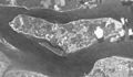
Satellite image of Pulau Ubin from 1965.
-
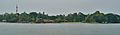
A wide view of Pulau Ubin.
-
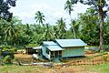
A traditional kampung house on Pulau Ubin.


See also
 In Spanish: Pulau Ubin para niños
