Queen Maud Gulf facts for kids
Quick facts for kids Queen Maud Gulf |
|
|---|---|
| Location | Nunavut, Canada |
| Coordinates | 68°20′N 102°00′W / 68.333°N 102.000°W |
| Type | Gulf |
| Ocean/sea sources | Arctic Ocean |
| Basin countries | Canada |
| Islands | Jenny Lind Island, King William Island, Royal Geographical Society Island |
|
Designations
|
|
| Official name: Queen Maud Gulf | |
| Designated: | 24 May 1982 |
|---|---|
| Reference #: | 246 |
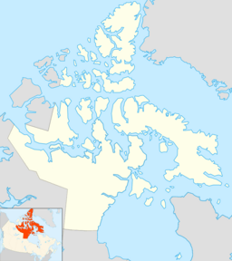
The Queen Maud Gulf is a large body of water in Nunavut, Canada. It is located between the northern mainland of Canada and the southeastern part of Victoria Island.
This gulf connects to other important waterways. To its west, you'll find Cambridge Bay, which leads to Dease Strait. To the east, it connects to Simpson Strait. To the north, it opens up to Victoria Strait. The Queen Maud Gulf is part of the vast Arctic Ocean.
Contents
Exploring the Queen Maud Gulf
The Queen Maud Gulf has a fascinating history of exploration. In 1839, two explorers named Peter Warren Dease and Thomas Simpson were the first to travel across it.
The gulf got its name in 1905 from a famous Norwegian explorer, Roald Amundsen. He named it after the Norwegian queen, Maud of Wales.
The Lost Ship of Franklin's Expedition
In 2014, an exciting discovery was made in the Queen Maud Gulf. The wreck of a ship called HMS Erebus was found at the bottom of the eastern part of the gulf. This ship was part of Franklin's lost expedition.
Sir John Franklin led this expedition in 1845. Their goal was to find the Northwest Passage, a sea route through the Arctic. Sadly, the expedition disappeared, and its fate remained a mystery for many years. The discovery of the Erebus helped solve part of that mystery. The wreck lies west of O'Reilly Island.
Islands in the Gulf
Several islands are located within the Queen Maud Gulf. These islands are important parts of the Arctic landscape.
See also
 In Spanish: Golfo de la Reina Maud para niños
 | Emma Amos |
 | Edward Mitchell Bannister |
 | Larry D. Alexander |
 | Ernie Barnes |


