
Quirindi facts for kids
Quick facts for kids QuirindiNew South Wales |
|||||||||
|---|---|---|---|---|---|---|---|---|---|

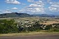
View over Quirindi from a nearby lookout
|
|||||||||

Quirindi
Location in New South Wales
|
|||||||||
| Established | 1856 | ||||||||
| Postcode(s) | 2343 | ||||||||
| Elevation | 390 m (1,280 ft) | ||||||||
| Location |
|
||||||||
| LGA(s) | Liverpool Plains Shire | ||||||||
| County | Buckland | ||||||||
| State electorate(s) | Upper Hunter | ||||||||
| Federal Division(s) | New England | ||||||||
|
|||||||||


Quirindi (say it like "kwa-RIN-dye" or "kuh-RIN-dye") is a small town in the North West Slopes area of New South Wales, Australia. It's part of the Liverpool Plains Shire, which is like a local government area.
In 2021, about 2,602 people lived in Quirindi. The town is a key link to other places like Gunnedah to the northwest and Tamworth to the north. The main way people make a living here is through farming. There's lots of "broadacre" farming, which means growing crops like wheat or cotton on large, flat areas. In the hilly eastern parts, people raise animals like cattle and sheep.
Quirindi is located on the Kamilaroi Highway. It's about 15 kilometers (9 miles) northwest of where the Kamilaroi Highway meets the New England Highway at a place called Willow Tree.
Contents
History of Quirindi
First People and the Town's Name
For thousands of years, the first people of this land, the Gamilaroi (or Gamilaraay) people, lived in the Quirindi area. The name "Quirindi" comes from their language. It can mean a few different things, like "nest in the hills," "place where fish breed," or "dead tree on a mountain top." In the past, people sometimes spelled it "Cuerindi" or "Kuwherindi."
When Quirindi Began
Quirindi got its first Post Office on January 1, 1858. This was an important step for the growing community. The town was officially recognized by the government on February 19, 1884. This meant it was a proper town with set boundaries.
Special Places in Quirindi
Quirindi has some places that are important because of their history. These are called "heritage-listed sites." One of these special places is the Quirindi railway station, which is part of the Main Northern railway line.
Sports and Fun in Quirindi
Quirindi has many places for sports and activities. There are several sports fields for athletics and cricket. The town also has teams for Rugby League (the Quirindi Grasshoppers) and Rugby Union (the Quirindi Lions). There's also a soccer team called Quirindi Football Club (QFC), which started in 2011.
You can also find courts for basketball and netball. Other sports facilities include a racecourse, polo grounds, and places for rodeo and campdrafting (a type of horse riding competition). There's an 18-hole golf course, two tennis clubs, three bowling greens, a gun club, and a swimming complex.
Local Sports Teams
- Quirindi Falcons Cricket Club
- Quirindi Lions Rugby Union Football Club
- Quirindi Lions Football Club (Soccer)
The local rugby league team, the Quirindi Grasshoppers, had some tough times and hasn't played since 2017. This means players often have to travel to nearby towns like Murrurundi or Werris Creek to play their favorite sport.
Horse Racing and Motorbikes
The Quirindi Jockey Club holds seven horse races each year. One of the biggest events is the Boxing Day Races in December, which brings in thousands of people.
If you like motorbikes, there's a motorcycle club about 5 kilometers (3 miles) northeast of Quirindi. It has a 1.2-kilometer (0.75-mile) motocross track called Stu Johnson Park.
Quirindi's Yearly Events
Quirindi hosts several exciting events throughout the year:
- Quirindi Rural Heritage Festival - This happens on the first weekend in May.
- Quirindi Show - You can enjoy this event in September.
- Boxing Day Races - A popular horse racing event in December.
- Prime Stock Show / Hook and Hoof - Held in August, this show highlights farm animals.
- Nick Tooth Memorial Rugby Tens Tournament - A rugby tournament.
- Sunflowers on the Plains - This beautiful event takes place in January.
Towns Near Quirindi
- Werris Creek is about 20 kilometers (12 miles) north of Quirindi. This path was once explored by Thomas Mitchell.
- Wallabadah is located about 15 kilometers (9 miles) east of Quirindi, right on the New England Highway.
- Spring Ridge is about 50 kilometers (31 miles) west of Quirindi.
Getting Around Quirindi
Train Travel
The Quirindi railway station is on the Main North railway line. It's about 392 kilometers (244 miles) from Sydney. The station first opened in 1877. Today, you can still catch a train here every day. The NSW TrainLink Xplorer train connects Quirindi to Sydney and to places like Armidale or Moree.
Air and Bus Travel
Quirindi Airport is the local airfield for smaller planes. However, most bigger commercial flights in the area use the Tamworth Regional Airport.
If you need to travel by bus, Tamworth Buslines offers a bus service between Quirindi and Tamworth.
Famous People from Quirindi
Some notable people have come from Quirindi:
- Ellen Savage - She was a nurse and the only nurse who survived when the AHS Centaur ship sank. She later became a strong supporter for nursing as a career.
- Sir John Oscar Cramer - An Australian politician who helped start the Liberal Party.
- Ben Smith - A former professional rugby league player for the Parramatta Eels.
- Andy Saunders - Another former professional rugby league player who played for the Canterbury Bulldogs.
- Tony Windsor - A well-known politician.
Images for kids
-
View over Quirindi from a nearby lookout
