Raccoon Creek (Tomhicken Creek tributary) facts for kids
Quick facts for kids Raccoon Creek |
|
|---|---|

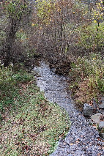
Raccoon Creek looking downstream in Nuremberg, Pennsylvania
|
|
| Physical characteristics | |
| Main source | valley between Little Sugarloaf Mountain and South Buck Mountain in Black Creek Township, Luzerne County, Pennsylvania 1,240 ft (380 m) |
| River mouth | Tomhicken Creek in North Union Township, Schuylkill County, Pennsylvania 902 ft (275 m) |
| Length | 3.3 mi (5.3 km) |
| Basin features | |
| Progression | Tomhicken Creek → Catawissa Creek → Susquehanna River → Chesapeake Bay |
| Basin size | 2.67 sq mi (6.9 km2) |
Raccoon Creek is a small stream in Pennsylvania, USA. It flows through parts of Luzerne County and Schuylkill County. This creek is about 3.3 miles (5.3 kilometers) long. It eventually joins a larger stream called Tomhicken Creek.
The area of land that drains into Raccoon Creek, known as its watershed, covers about 2.67 square miles (6.9 square kilometers). Raccoon Creek is special because it's considered a "High-Quality Coldwater Fishery." This means its water is clean and cold, making it a great home for fish. It's also known as "Class A Wild Trout Waters," which means wild trout live and reproduce here naturally.
Contents
Where Raccoon Creek Flows: Its Journey
Raccoon Creek starts in a valley. This valley is located between two mountains: Little Sugarloaf Mountain and another ridge. It begins in a place called Black Creek Township in Luzerne County.
The creek flows mostly west. After a short distance, it passes through a small community called Weston. It continues flowing west for over a mile. Then, it turns southwest and leaves Luzerne County.
After leaving Luzerne County, Raccoon Creek enters North Union Township in Schuylkill County. It keeps flowing southwest, running along the edge of the town of Nuremberg. As the creek moves through North Union Township, the valley around it becomes narrower. Finally, Raccoon Creek meets and joins Tomhicken Creek.
Raccoon Creek joins Tomhicken Creek about 3.40 miles (5.47 kilometers) before Tomhicken Creek reaches its own end.
Water Quality: What's in the Water?
The water in Raccoon Creek has an alkalinity of 20 milligrams per liter. The pH of the creek's water is 7.0, which is neutral. The water's hardness is 36 milligrams per liter. Human activities in the area can affect the water's chemistry.
On a summer day in 1997, the air temperature near the creek was 28 degrees Celsius (82 degrees Fahrenheit). At the same time, the water temperature of Raccoon Creek was measured at 16.8 degrees Celsius (62.2 degrees Fahrenheit). The specific conductivity of the water, which measures how well it conducts electricity, was 129 umhos.
Land and Rocks Around the Creek
The land near where Raccoon Creek joins Tomhicken Creek is about 902 feet (275 meters) above sea level. Near where the stream begins, the elevation is a bit higher, over 1240 feet (378 meters) above sea level.
The entire area that drains into Raccoon Creek has rocks from the Mauch Chunk Formation. However, the northern edge of this area also has rocks from the Pottsville Formation. The soil along the entire length of the creek is called Leck Kill soil.
The very beginning of Raccoon Creek is found between Little Sugarloaf Mountain and South Buck Mountain. Raccoon Creek is a small stream, only about 2.2 meters (7.2 feet) wide. It flows downhill at a moderate rate of 19.9 meters per kilometer. Sometimes, the creek can overflow its banks and cause flooding in nearby homes.
The Raccoon Creek Watershed: Land Use and Roads
The watershed of Raccoon Creek covers an area of 2.67 square miles (6.9 square kilometers). Most of this watershed is in Black Creek Township, Luzerne County. However, a good part of it is also in North Union Township, Schuylkill County.
Much of the lower part of the stream, in Schuylkill County, flows through farmland. In the upper parts of the watershed, there are two developed areas: the communities of Nuremberg and Weston.
Important roads in the Raccoon Creek watershed include Mahanoy Street, Main Street, and Weston Road. The town of Nuremberg is located in the northeastern part of the watershed. About 43 percent of Raccoon Creek's length is within 100 meters (330 feet) of a road. Almost all of the creek (99 percent) is within 300 meters (980 feet) of a road, and the entire creek is within 500 meters (1,600 feet) of a road.
Raccoon Creek is located in the Nuremberg area on maps from the United States Geological Survey.
History and Fun Activities
In 2011, Black Creek Township in Luzerne County received a grant of $10,000. This money was used to study Raccoon Creek. The goal of the study was to find ways to reduce flooding that affected homes nearby. It also aimed to make the creek's banks more stable.
The North Union Township Park is located close to Raccoon Creek, offering a place for people to enjoy the outdoors.
Wildlife: Fish in Raccoon Creek
The Pennsylvania Department of Environmental Protection considers Raccoon Creek a High-Quality Coldwater Fishery. This means it has very good, cold water that supports fish life. It is also listed by the Pennsylvania Fish and Boat Commission as Class A Wild Trout Waters. This is because brook trout naturally live and reproduce in the stream from its beginning to its end.
Seven different kinds of fish have been found in Raccoon Creek. These include brook trout and largemouth bass. The largemouth bass likely came from nearby farm ponds. Trout naturally reproduce in the stream.
A study in 1997 found many brook trout in the creek. There were 335 brook trout per kilometer that were less than 175 millimeters long. There were also 120 brook trout per kilometer that were more than 175 millimeters long. The study also noted that Raccoon Creek was an excellent place for angling, which means fishing with a rod and line.
 | Misty Copeland |
 | Raven Wilkinson |
 | Debra Austin |
 | Aesha Ash |


