
Ralston Peak facts for kids
Quick facts for kids Ralston Peak |
|
|---|---|
 |
|
| Highest point | |
| Elevation | 9,239 ft (2,816 m) NAVD 88 |
| Prominence | 1,075 ft (328 m) |
| Listing | Tahoe OGUL Peak List |
| Geography | |
| Location | El Dorado County, California, U.S. |
| Parent range | Sierra Nevada |
| Topo map | USGS Echo Lake |
| Climbing | |
| Easiest route | Hike, class 1 |
Ralston Peak is a tall mountain located in the Sierra Nevada mountain range in California. It stands west of Lake Tahoe within the Desolation Wilderness, a special protected area in El Dorado County, California. Many people love to hike to the top of Ralston Peak. They go for the amazing views of the wilderness. The mountain is also easy to reach because it is very close to U.S. Route 50.
Contents
Exploring Ralston Peak
Ralston Peak is a popular spot for hikers. It offers incredible views of the surrounding natural beauty. The mountain is known for being quite accessible. This makes it a favorite for many visitors to the area.
How to Reach the Summit
There are a couple of main ways to hike to the top of Ralston Peak. Each path offers a different experience. You can choose the one that best fits your hiking style.
Starting from Camp Sacramento
The closest place to start your hike is from Camp Sacramento. This trailhead is just a few miles west of Echo Summit. This route is generally shorter and more direct. It is a good choice if you want to reach the summit quickly.
Using the Pacific Crest Trail
Another way to get to Ralston Peak is from the Pacific Crest Trail. This famous long-distance trail passes between Echo Lake and Lake Aloha. If you start from Echo Lake, this path is much longer than the one from Camp Sacramento. However, the climb is less steep. This means you gain altitude more slowly, which can be easier for some hikers.

Images for kids
-
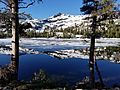
Tamarack Lake with Ralston Peak in background
.jpg)
