Rancheria Creek (Tuolumne County, California) facts for kids
Quick facts for kids Rancheria Creek |
|
|---|---|

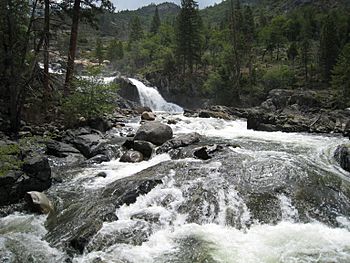
Below Rancheria Falls
|
|
|
Location of Rancheria Creek in California
|
|
| Country | United States |
| State | California |
| Physical characteristics | |
| Main source | Peeler Lake Sierra Nevada 9,494 ft (2,894 m) 38°07′22″N 119°28′14″W / 38.12278°N 119.47056°W |
| River mouth | Tuolumne River Hetch Hetchy Reservoir 3,796 ft (1,157 m) 37°57′12″N 119°43′41″W / 37.95333°N 119.72806°W |
| Length | 22.56 mi (36.31 km) |
Rancheria Creek is a stream in California, United States. It flows for about 22 miles (35 kilometers) through the northern part of Yosemite National Park. Most of the creek is located in Tuolumne County. Rancheria Creek is a major tributary (a smaller stream that flows into a larger one) of the Tuolumne River. It is the biggest tributary of the Tuolumne River found inside Yosemite National Park. On some older maps, this stream was called Kerrick Creek.
Contents
Rancheria Creek's Journey
Rancheria Creek starts high up in the mountains at Peeler Lake. This lake is located near the Sierra Crest, which is the highest part of the Sierra Nevada mountain range. The creek begins in Mono County and quickly flows west into Tuolumne County.
Flowing Through Valleys and Canyons
The creek first flows south through beautiful areas like Kerrick Meadow. It passes through several high mountain valleys. When it reaches Kerrick Canyon, the creek makes a sharp turn and flows west. The famous Pacific Crest Trail, a long hiking path, runs alongside the creek through Kerrick Canyon.
After leaving Kerrick Canyon, Rancheria Creek turns southwest. Along its path, it collects water from other smaller streams. These include a major stream from Stubblefield Canyon and another called Tilden Creek.
The Final Stretch to Hetch Hetchy
As it continues southwest, the creek flows through rocky areas with interesting granite formations. It then receives water from Breeze Creek. For its last few miles, Rancheria Creek turns west again.
Before it reaches its end, the creek drops about 150 feet (46 meters) over Rancheria Falls. Finally, it empties into the Hetch Hetchy Reservoir. This reservoir is a large lake created by a dam. Rancheria Creek joins the reservoir right next to another stream called Tiltill Creek.
Before the Dam
Before the O'Shaughnessy Dam was built in 1923, the Hetch Hetchy Valley was a natural valley, not a reservoir. In those days, Rancheria Creek and Tiltill Creek would join together. Then, their combined waters would flow into the Tuolumne River on the valley floor.
 | Bayard Rustin |
 | Jeannette Carter |
 | Jeremiah A. Brown |


