Ranson, West Virginia facts for kids
Quick facts for kids
Ranson, West Virginia
|
|||
|---|---|---|---|

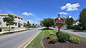
Welcome sign in the median of South Fairfax Blvd
|
|||
|
|||

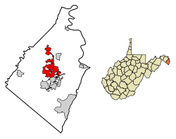
Location of Ranson in Jefferson County, West Virginia.
|
|||
| Country | United States | ||
| State | West Virginia | ||
| County | Jefferson | ||
| Area | |||
| • Total | 8.09 sq mi (20.96 km2) | ||
| • Land | 8.09 sq mi (20.95 km2) | ||
| • Water | 0.00 sq mi (0.00 km2) | ||
| Population
(2020)
|
|||
| • Total | 5,433 | ||
| • Density | 671.6/sq mi (259.21/km2) | ||
| Time zone | UTC-5 (Eastern (EST)) | ||
| • Summer (DST) | UTC-4 (EDT) | ||
| ZIP code |
25438
|
||
| Area code(s) | 304, 681 | ||
| FIPS code | 54-18040 | ||
Ranson is a city located in Jefferson County, West Virginia, USA. In 2020, about 5,433 people lived there. It's also near the edge of the larger Washington metropolitan area.
Contents
History of Ranson
Ranson was created with a lot of help from the Charles Town Mining, Manufacturing, and Improvement Company. In 1890, this company bought 850 acres (about 3.4 square kilometers) of land next to Charles Town, West Virginia. They hired D.G. Howell, an engineer, to design the new town. The biggest piece of land they bought was from the Ranson family.
Ranson officially became a town in 1910. Residents voted 67 to 2 to form their own town. It was named after Dr. James Ranson, who was a dentist and farmer in the area.
Early Growth and Development
Ranson grew quickly in the late 1800s. This was because railroads, mining, and factories were becoming very popular in the Shenandoah Valley. Early photos of Ranson show the company's offices and the Hotel Powhatan. Some of the first businesses in Ranson included the Hotel Powhatan, a saddlery, and metalworking shops.
One very important building was the Hotel Powhatan. This large, four-story hotel opened in October 1891. It later became the Powhatan College for Young Women in 1900. In 1915, it reopened as St. Hilda's Hall for Girls, a Christian school. A new building called Peterkin Hall was added in 1921. This building now holds offices for Amerigas. The original hotel building burned down in 1937.
Ranson's Growth Over Time
In 1936, the town of Ranson bought the old company office building for $3,000. They turned it into their town hall. The city renovated this building in 2003.
Ranson's population has grown a lot over the years:
- By 1941, 1,171 people lived there.
- By 1950, the population was 1,436.
- By 1970, it reached 2,189.
- In 2000, Ranson had 2,951 residents.
- By 2010, the population jumped to 4,440, a big increase!
To help with this growth, the city council added thousands of acres of land to Ranson. This new land now has homes, businesses, and farms.
Ranson Today
Today, Ranson is changing from a small factory town to a mix of big companies and quiet neighborhoods. Many homes are from the early 1900s. Newer homes and apartments have been built, especially on the west and north sides of the city.
Ranson continues to welcome businesses. In 1948, the Charles Town General Hospital opened where the Hotel Powhatan used to be. This helped Ranson become a center for medical care. In 1975, Jefferson Memorial Hospital (now Jefferson Medical Center) opened. It still serves the people of Jefferson County.
The Hollywood Casino at Charles Town Races is just outside Ranson. It's very important for the city's economy. It provides over 1,200 jobs and brings in millions of dollars in taxes. These taxes have helped Ranson buy police cars, improve streets, and fix up City Hall.
In 2004, the Potomac Marketplace shopping area began to be built. It includes popular stores and restaurants like Home Depot, Kohl's, and McDonald's.
How Ranson is Governed
Ranson is run by a mayor, a recorder, and five city council members. They each serve four-year terms. The city also has a city manager who helps run the government every day.
The Ranson Police Department protects the city's citizens 24/7. City Hall has departments for planning, public works, finance, and legal matters. These departments provide services to the people living in Ranson. Two volunteer fire departments, Independent Fire Company and Citizens Fire Company, protect the city from fires. Ranson also has its own court system.
Geography of Ranson
Ranson is located at 39°17′55″N 77°51′40″W / 39.29861°N 77.86111°W.
The United States Census Bureau says Ranson has a total area of about 8.05 square miles (20.85 square kilometers), all of it land. However, since 2004, Ranson has added about 5,000 acres (20 square kilometers) of land. This means the city's total land area is now about 9 square miles (23 square kilometers).
Demographics
Demographics tell us about the people who live in a place. This includes things like how many people there are, their ages, and their backgrounds.
| Historical population | |||
|---|---|---|---|
| Census | Pop. | %± | |
| 1920 | 699 | — | |
| 1930 | 1,002 | 43.3% | |
| 1940 | 1,171 | 16.9% | |
| 1950 | 1,436 | 22.6% | |
| 1960 | 1,974 | 37.5% | |
| 1970 | 2,189 | 10.9% | |
| 1980 | 2,471 | 12.9% | |
| 1990 | 2,890 | 17.0% | |
| 2000 | 2,951 | 2.1% | |
| 2010 | 4,440 | 50.5% | |
| 2020 | 5,433 | 22.4% | |
| U.S. Decennial Census 2020 | |||
2020 Census Information
The table below shows the different groups of people living in Ranson in 2010 and 2020.
| Race / Ethnicity | Pop 2010 | Pop 2020 | % 2010 | % 2020 |
|---|---|---|---|---|
| White alone (NH) | 3,062 | 3,444 | 68.96% | 63.39% |
| Black or African American alone (NH) | 615 | 602 | 13.85% | 11.08% |
| Native American or Alaska Native alone (NH) | 5 | 9 | 0.11% | 0.17% |
| Asian alone (NH) | 55 | 155 | 1.24% | 2.85% |
| Pacific Islander alone (NH) | 3 | 0 | 0.07% | 0.00% |
| Some Other Race alone (NH) | 1 | 37 | 0.02% | 0.68% |
| Mixed Race/Multi-Racial (NH) | 161 | 432 | 3.63% | 7.95% |
| Hispanic or Latino (any race) | 538 | 754 | 12.12% | 13.88% |
| Total | 4,440 | 5,433 | 100.00% | 100.00% |
Note: The US Census counts Hispanic/Latino as a background, separate from race. People who are Hispanic/Latino can be of any race.
2010 Census Details
In 2010, there were 4,440 people living in Ranson. There were 1,699 households (groups of people living together) and 1,150 families. The population density was about 551.6 people per square mile (213.0 per square kilometer).
About 74.3% of the people were White, 14.1% were African American, and 1.4% were Asian. About 12.1% of the population was Hispanic or Latino.
Of the households, 38.6% had children under 18 living with them. About 42.9% were married couples. The average household had 2.61 people.
The average age in Ranson was 33 years old. About 26.6% of residents were under 18. About 9.2% were 65 years or older. There were slightly more females (51.5%) than males (48.5%).
Transportation
The main road in Ranson is West Virginia Route 9. This highway is like an expressway through the city. It connects Ranson and nearby Charles Town to Leesburg and Martinsburg. WV 9 also links to U.S. Route 340 and Interstate 81. Another road serving Ranson is West Virginia Route 115. This road follows the old path of WV 9 before the new expressway was built.
See also
 In Spanish: Ranson (Virginia Occidental) para niños
 | Ernest Everett Just |
 | Mary Jackson |
 | Emmett Chappelle |
 | Marie Maynard Daly |


