Raven Ridge (Washington) facts for kids
Quick facts for kids Raven Ridge |
|
|---|---|

Raven Ridge
|
|
| Highest point | |
| Elevation | 8,572 ft (2,613 m) |
| Prominence | 1,092 ft (333 m) |
| Isolation | 4.53 mi (7.29 km) |
| Geography | |
| Parent range | North Cascades |
| Topo map | USGS Martin Peak |
| Climbing | |
| Easiest route | Scrambling |
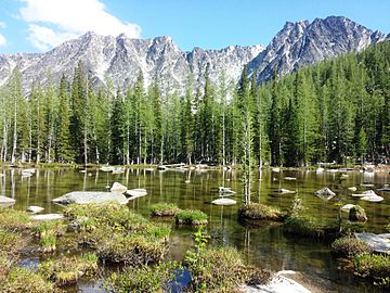
Raven Ridge is a tall mountain ridge in Washington state. It stands about 8,572 feet (2,613 meters) high. This ridge is part of the Methow Mountains, which are a smaller group within the North Cascades.
The land around Raven Ridge is protected. It's located inside the Lake Chelan-Sawtooth Wilderness, which is part of the Okanogan National Forest. The very top of Raven Ridge is called Corax Peak. Another high point on the west side is Libby Peak, which is almost as tall.
Raven Ridge is not the highest peak nearby. Star Peak is taller and sits about 4.5 miles (7.3 km) to the west. Hoodoo Peak is also close, just one mile (1.6 km) north. Water from the mountain flows into streams that join the Methow River. The Methow River then flows into the large Columbia River.
Weather at Raven Ridge
Raven Ridge is located east of the Cascade Range. This means the weather here is a bit drier than areas to the west. In summer, it can get warm, and sometimes there are thunderstorms.
Because the ridge is so high, you might see snow on it in late spring and early fall. Winters can be very cold with lots of snow.
How Raven Ridge Was Formed
The North Cascades area has very rugged land. You can see sharp peaks, long ridges, and deep valleys carved by glaciers. These amazing shapes were created by geological events over millions of years. These events also caused big changes in height, which led to different climates. These different climates then created various types of plants and animals in the area.
The Cascade Mountains started forming millions of years ago. This happened when the North American Plate slowly moved over the Pacific Plate. This movement caused volcanoes to erupt many times. Also, small pieces of land, called terranes, joined together to form the North Cascades about 50 million years ago.
Later, during the Ice Age (the Pleistocene period), glaciers moved across the land many times. They scraped away rock and left behind piles of debris. The "U"-shaped valleys you see were carved out by these glaciers. The combination of land pushing up (uplift) and cracks in the Earth (faulting), along with glaciers, created the tall peaks and deep valleys of the North Cascades.
 | William M. Jackson |
 | Juan E. Gilbert |
 | Neil deGrasse Tyson |


