
Redoubt Peak facts for kids
Quick facts for kids Redoubt Peak |
|
|---|---|

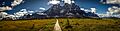
Redoubt Peak seen from Amethyst Lakes at sunrise
|
|
| Highest point | |
| Elevation | 3,109 m (10,200 ft) |
| Prominence | 169 m (554 ft) |
| Geography | |

Redoubt Peak
Location in Alberta

Redoubt Peak
Location in Canada
|
|
| Location | Alberta British Columbia |
| Parent range | Park Ranges Canadian Rockies |
| Topo map | NTS 83D/09 |
| Climbing | |
| First ascent | 1927 F. H. Slark; F. Rutishauser |
| Easiest route | North-West Ridge III 5.6 East Face IV 5.7 |
Redoubt Peak is a tall mountain in Canada. It stands 3,109 meters (about 10,197 feet) high. This peak is special because it sits right on the border. One side is in Jasper National Park in Alberta. The other side is in Mount Robson Provincial Park in British Columbia.
Redoubt Peak is part of a mountain range called The Ramparts. These mountains are found within the larger Canadian Rockies. The mountain got its name in 1920. It looks a bit like a "redoubt," which is a strong fort or castle outpost. Its closest tall neighbor is Dungeon Peak. Dungeon Peak is only about 0.6 kilometers (0.4 miles) away to the southeast.
Mountain History
The first time someone successfully climbed to the very top of Redoubt Peak was in 1927. Two climbers, F. H. Slark and F. Rutishauser, reached the summit. Sadly, they did not survive their trip back down the mountain. The next summer, in 1928, their note from the top was found. This note proved they had made it to the summit.
The mountain's name, Redoubt Peak, became official in 1935. The Geographical Names Board of Canada made this decision.
Mountain Climate
Redoubt Peak is located in a subarctic climate zone. This means it has very cold, snowy winters. The summers are usually mild. Temperatures can drop below -20 °C (-4 °F). With the wind, it can feel even colder, sometimes below -30 °C (-22 °F).
Water from melting snow and rain flows off Redoubt Peak. On the east side, this water drains into the Athabasca River. On the west side, the water flows into the Fraser River.
Images for kids
-
The Ramparts in Tonquin Valley with Redoubt on right
-
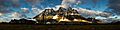
Sunrise and cloud shadows on the Tonquin Valley Ramparts. Oubliette Mountain (left), Dungeon Peak (middle), Redoubt Peak (right)
