
Roatán facts for kids

Roatán, Bay Islands
|
|

Roatán
Location in Honduras

Roatán
Location in Caribbean
|
|
| Geography | |
|---|---|
| Location | Caribbean Sea |
| Coordinates | 16°23′N 86°24′W / 16.383°N 86.400°W |
| Archipelago | Bay Islands |
| Total islands | 7 |
| Major islands | Roatán, Útila and Guanaja |
| Area | 83 km2 (32 sq mi) |
| Length | 59 km (36.7 mi) |
| Width | 8 km (5 mi) |
| Coastline | 154 km (95.7 mi) |
| Highest point | 221 m (725.1 ft) |
| Administration | |
|
Honduras
|
|
| Department | Bay Islands |
| Municipality | Islas de la Bahia |
| Largest settlement | Coxen Hole (pop. 12,500) |
| Mayor | Diego Sosa |
| Demographics | |
| Population | 110,000 (2020) |
| Pop. density | 538 /km2 (1,393 /sq mi) |
| Ethnic groups | Islanders (see Demographics), Kalinago, Taíno, Garifuna, Expatriates |
| Additional information | |
| Time zone |
|
Roatán is a beautiful island in the Caribbean Sea. It's about 65 kilometers (40 miles) off the northern coast of Honduras. Roatán is the biggest of the Bay Islands in Honduras. You can find it between the islands of Utila and Guanaja.
The island stretches about 77 kilometers (48 miles) long. But it's less than 8 kilometers (5 miles) wide at its widest part. Roatán is divided into two main areas called municipalities. These are José Santos Guardiola in the east and Roatán in the west. The western part also includes the Cayos Cochinos islands. Long ago, people sometimes called the island Ruatan or Rattan.
Contents
Exploring Roatán's Geography


Roatán is a special kind of island. It's a coral island, meaning it formed from ancient coral reefs. The island rises about 270 meters (886 feet) above the sea.
The eastern part of the island has a narrow channel. This channel is about 15 meters (50 feet) wide. It cuts through a mangrove forest and leads to a section called Helene, or Santa Elena. Close by, you'll find smaller islands like Morat, Barbareta, and Pigeon Cay.
Most of the buildings and roads are on the western side of Roatán. The largest town on the island is Coxen Hole. This town is the capital of the Roatán municipality. It's located on the southwest coast.
West of Coxen Hole, there are small towns. These include Gravel Bay, Flowers Bay, and Keyhole Bay on the south coast. On the north coast, you'll find Sandy Bay, West End, and West Bay. East of Coxen Hole, there are several small islands called cays. These include Jesse Arch Cay, Sarah Cay, and Second Cay. Further east, you can visit Mount Pleasant, French Harbour, French Cay, First Bight, Parrot Tree, Jonesville, and Oakridge on the south coast. Punta Gorda is on the north coast.
A Look at Roatán's History


The first people on the Bay Islands were likely related to the Paya, Maya, Lenca, or Tolupan tribes. These tribes lived on the mainland of Honduras.
In 1502, Christopher Columbus visited the nearby island of Guanaja. Soon after, Spanish explorers came to the islands. They began trading for people to work as slaves. Even worse, the local people caught diseases like smallpox and measles. They had no protection against these illnesses.
Pirates and European Control
For many years, the Bay of Honduras was a busy place. It attracted settlers, pirates, traders, and soldiers from Europe. Different European countries, mainly Britain and Spain, fought for control. Sea travelers often stopped at Roatán to rest.
Between 1550 and 1700, the English often took control of the Bay Islands. During this time, buccaneers, who were like pirates, found the islands to be a safe place. English, French, and Dutch pirates set up homes there. They often attacked Spanish ships carrying gold and silver.
In 1722, a fisherman named Philip Ashton escaped from a pirate ship on Roatán. He wrote about his year living alone on the island. This gives us a peek into the island's past after the Paya people were gone.
During a war called the War of the Austrian Succession, British soldiers lived on the island. This was from 1742 to 1749.
Garifuna People Arrive
In 1797, the British fought against the Garifuna people. The Garifuna were supported by the French. After the British won, they sent the Garifuna to Roatán. Most Garifuna moved to Trujillo on the mainland. But some stayed and started the community of Punta Gorda on Roatán's north coast.
The Garifuna people have roots from Arawak and Maroon groups. They became the first permanent settlers on the Bay Islands after Columbus. They also spread to other parts of Central America. Today, they form the basis of the modern Garífuna culture in Honduras, Belize, and Guatemala.
Settlers from the Cayman Islands
Most of Roatán's permanent population came from the Cayman Islands. They arrived in the 1830s after slavery was ended. The changes in work systems affected the Cayman Islands' economy. Many of these people were sailors and knew the area well.
Former slave owners from the Cayman Islands were among the first to settle along Roatán's coasts. Later, in the 1830s and 1840s, more former slaves also moved from the Cayman Islands. Together, these people from the Cayman Islands became the largest cultural group on Roatán.
Modern Roatán
In the 1850s, Britain briefly made the Bay Islands a colony. But within ten years, they gave the islands back to Honduras. Later, in the 20th century, more people moved to Roatán. Many Spanish-speaking people from mainland Honduras came. This caused the island's population to triple.
These new residents mostly settled in towns like Coxen Hole and Barrio Los Fuertes. Even more people came when tourism grew in the 21st century. Many people from the United States, Canada, and other countries moved here. They helped grow the fishing and diving industries. These industries then attracted many tourists.
In 1998, Hurricane Mitch caused some damage to Roatán. It stopped most businesses for a while. The storm also broke up two popular dive sites, the Aguila and Odyssey shipwrecks.
Who Lives on Roatán?


In 2013, a census counted 41,831 people living in Roatán.
- About 52% were Mestizo (people of mixed European and Indigenous ancestry).
- About 21% were Black or Afro-Honduran.
- About 12% were White.
- About 11% were Indigenous (including Chʼortiʼ, Lenca, Miskito, and Pech).
- About 3% were from other groups.
Islanders of Roatán
The English-speaking people who have lived in the Bay Islands since the early 1800s are called "Islanders." They are mostly of European and British-Afro-Caribbean background. Sometimes, Spanish-speaking Hondurans call them "caracoles" (snails), but Islanders find this term offensive.
The Bay Islands include Roatán, Útila, Guanaja, and smaller islands. English is the first language for native Islanders, no matter their background. Spanish is spoken second. This is different from mainland Honduras, where Spanish is the main language. This is because the islands were once a British colony.
Over time, the English spoken by Islanders has changed a bit. It's still easy to understand for most English speakers. With more people moving from mainland Honduras, Spanish is heard more often. But because of tourism, English remains the main language.
Protecting Roatán's Environment


Roatán sits on the edge of the Mesoamerican Barrier Reef System. This is the second-largest barrier reef in the world! Reefs are very delicate. Around the world, many reefs have been damaged.
On Roatán, too much tourism and a growing population are putting stress on nature. Cutting down forests, dirty water runoff, poor waste treatment, and pollution are big threats. These harm both the land and the ocean.
Efforts to Protect the Island
Between 2003 and 2005, the town of Coxen Hole was rebuilt. New pipes for water and waste were added. A new water treatment plant and a waste recycling plant were also built. These help manage the island's growing needs.
A similar project was finished in West End Village. This area is popular for tourism and diving. It now has new roads, pumping stations, and drainage systems. These projects help keep the island cleaner. Not long ago, many homes used simple out-houses over the water.
The Roatán Marine Park has done a lot to help. They started recycling on the island. They also organize popular "Coastal clean up" events. Schools, residents, and people from other countries living on the island all join in. The Marine Park has experts like divers and marine biologists.
In 2019, the local government made a rule. It banned plastic bags, bottles, containers, and styrofoam. The island plans to keep making more rules to protect the environment.
Important Bird Area
Roatán is part of an Important Bird Area (IBA). This means it's a special place for birds. It's home to many white-crowned pigeons, chimney swifts, and yellow-naped amazons.
Roatán Marine Park
The Roatán Marine Park (RMP) is a group started by local people. It's a non-profit organization. It began in 2005 when dive operators and businesses wanted to protect Roatán's coral reefs.
At first, the RMP focused on patrolling the Sandy Bay-West End Marine Reserve. They wanted to stop harmful fishing. Over time, they added more programs. These include patrols, education, and public awareness to protect Roatán's natural resources.
In 2017, the East End Chapter of the RMP was created. This helped expand their work across the whole island. Their efforts have led to more fish and a big increase in turtle nesting. They also plan to expand education and help local people find new ways to earn a living.
Roatan Institute of Marine Science
The Roatan Institute for Marine Sciences (RIMS) started in 1989. Its main goal is to protect Roatán's natural resources through learning and research. RIMS is in Sandy Bay, at Anthony's Key Resort. It's surrounded by reefs, seagrass beds, and mangroves.
For over 25 years, RIMS has been a teaching center. Colleges and universities from other countries visit to study the ocean's ecosystems. They also study the bottlenose dolphins that live there.
Working Together for Conservation
All the reef systems around the Bay Islands are protected. This is thanks to the local government, donations, and people working hard. Local donations to the Marine Park and efforts from resorts help. Weekly clean-ups happen to make sure no trash harms the reefs or beaches. Dive shops also clean up during their daily dives. People on the island are working together to protect and educate others about their beautiful home.
Getting Around Roatán
Airport Travel
The Juan Manuel Gálvez International Airport (RTB) on Roatán is one of Honduras's international airports. It receives flights from other countries.
You can fly directly to Roatán from cities like Houston, Atlanta, Dallas/Fort Worth, Miami, Denver, and San Salvador. There are also flights to other cities within Honduras. During winter, airlines like Sunwing Airlines fly from Canada. Sun Country Airlines also flies from Minneapolis. WestJet started flights to the island in 2019.
Ferry Services
The Galaxy Wave ferry offers trips from Roatán to La Ceiba twice a day. The Utila Dream ferry also provides service from Roatán to Utila and then to La Ceiba twice daily.
Special Economic Zone
Roatán has a special area called a "Zona de Empleo y de Desarrollo Económico" (ZEDE). This means "Zone for Economic Development and Employment." It's set up by Honduran laws. The goal is to create stable rules and a good environment. This helps encourage businesses, people to move there, and economic growth. One example is the private city of Próspera.
Images for kids
-
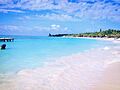
Roatán, Bay Islands
-
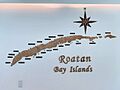
Roatán Bay Islands from hotel lobby display
-
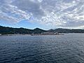
Roatán from cruise ship
-
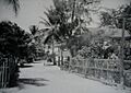
French Harbour in the 1960s
-
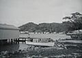
Oak Ridge in the 1960s
-
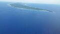
Roatán looking southeast with West Bay on the right and Coxen Hole and Manuel Galvez airport in the upper middle.
-
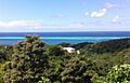
Roatán looking north towards West End
-
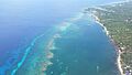
View from Big Bight over the Mesoamerican Barrier Reef System, second-largest barrier reef in the world
-
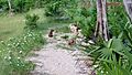
Roatán Island Agouti—Dasyprocta ruatanica
See also
 In Spanish: Roatán para niños
