Rocheport, Missouri facts for kids
Quick facts for kids
Rocheport, Missouri
|
|
|---|---|
| City of Rocheport | |

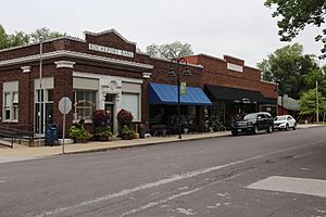
Rocheport, Missouri in 2018
|
|

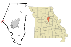
Location of Rocheport, Missouri
|
|
| Country | United States |
| State | Missouri |
| County | Boone |
| Area | |
| • Total | 0.32 sq mi (0.82 km2) |
| • Land | 0.32 sq mi (0.82 km2) |
| • Water | 0.00 sq mi (0.00 km2) |
| Elevation | 594 ft (181 m) |
| Population
(2020)
|
|
| • Total | 201 |
| • Density | 634.07/sq mi (244.93/km2) |
| Time zone | UTC-6 (Central (CST)) |
| • Summer (DST) | UTC-5 (CDT) |
| ZIP code |
65279
|
| Area code(s) | 573 |
| FIPS code | 29-62498 |
| GNIS feature ID | 2396393 |
| Website | https://rocheport.com/ |
Rocheport is a small city in Boone County, Missouri, United States. It is part of the Columbia, Missouri area. In 2020, 201 people lived there. Rocheport is known for its Rocheport Historic District. This area has many old buildings from the 1830s. It is also listed on the National Register of Historic Places.
Contents
History of Rocheport
Rocheport started as a place where settlers and Native Americans traded goods. After the United States bought the Louisiana Territory in 1803, President Thomas Jefferson sent Meriwether Lewis and William Clark to explore the western lands.
Lewis and Clark Expedition
On June 7, 1804, Lewis and Clark reached the spot where the Missouri River meets Moniteau Creek. This was near where Rocheport would later be built. Clark wrote in his journal about the land, plants, animals, and pictures drawn on the cliffs by Native Americans.
Early Settlements
The Sauk leader Quashquame had a village nearby in the early 1800s. People from the Sauk, Meskwaki, and Ioway tribes lived there. This village was along Moniteau Creek. Zebulon Pike noted it in 1806. Rocheport became a permanent town in the early 1800s. Its name is French and means "rocky port."
Historic Homes
The Moses U. Payne House is a historic building. It is located just outside Rocheport.
Geography of Rocheport
Rocheport covers a total area of about 0.27 square miles (0.70 square kilometers). All of this area is land.
Population and People
Rocheport's population has changed over the years. Here is a look at how many people have lived there:
| Historical population | |||
|---|---|---|---|
| Census | Pop. | %± | |
| 1860 | 735 | — | |
| 1870 | 823 | 12.0% | |
| 1880 | 728 | −11.5% | |
| 1890 | 631 | −13.3% | |
| 1900 | 593 | −6.0% | |
| 1910 | 434 | −26.8% | |
| 1920 | 458 | 5.5% | |
| 1930 | 455 | −0.7% | |
| 1940 | 396 | −13.0% | |
| 1950 | 376 | −5.1% | |
| 1960 | 375 | −0.3% | |
| 1970 | 307 | −18.1% | |
| 1980 | 272 | −11.4% | |
| 1990 | 255 | −6.2% | |
| 2000 | 208 | −18.4% | |
| 2010 | 239 | 14.9% | |
| 2020 | 201 | −15.9% | |
| U.S. Decennial Census | |||
Life in Rocheport
In 2010, there were 239 people living in Rocheport. There were 121 households. About 19% of households had children under 18. The average age of people in the city was 49.3 years.
Fun Things to Do in Rocheport
Rocheport has many fun things for visitors and residents. You can find different shops, art galleries, and restaurants. There are also many outdoor activities to enjoy.
Katy Trail State Park
Rocheport is located near the middle of the Katy Trail. This is a very long bike path, stretching 225 miles across Missouri. It was built on an old railroad track. It's a great place for biking, walking, and enjoying nature.
Famous People from Rocheport
- David W. Alexander: He was a politician and sheriff in Los Angeles, California, in the 1800s.
See also
 In Spanish: Rocheport (Misuri) para niños

