Rock Hill, Missouri facts for kids
Quick facts for kids
Rock Hill, Missouri
|
|
---|---|
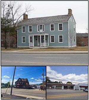
Top: The Fairfax House, Bottom Left: Trainwreck Saloon, Bottom Right: Former Rock Hill City Hall
|
|
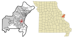
Location of Rock Hill, Missouri
|
|
Country | United States |
State | Missouri |
County | St. Louis |
Incorporated as village | April 1929 |
Incorporated as city | April 1947 |
Founded by | James Collier Marshall |
Area | |
• Total | 1.10 sq mi (2.86 km2) |
• Land | 1.10 sq mi (2.86 km2) |
• Water | 0.00 sq mi (0.00 km2) |
Elevation | 541 ft (165 m) |
Population
(2020)
|
|
• Total | 4,750 |
• Density | 4,306.44/sq mi (1,662.26/km2) |
Time zone | UTC-6 (Central (CST)) |
• Summer (DST) | UTC-5 (CDT) |
ZIP Code |
63119
|
Area code(s) | 314 |
FIPS code | 29-62660 |
GNIS feature ID | 2396399 |
Rock Hill is a suburban town in St. Louis County, Missouri, United States. The population was 4,635 at the 2010 census. It is home to the Fairfax House on the National Register of Historic Places.
Contents
Geography
According to the United States Census Bureau, the city has a total area of 1.09 square miles (2.82 km2), all land.
Rock Hill is bounded by cities Ladue, Brentwood, Webster Groves, Glendale and Warson Woods.
- Streets
Manchester Road is four lanes and runs east–west across Rock Hill. North Rock Hill Road was connected to the South McKnight Road extension in June 1962. Voters passed a $3 million bond issue to repair roads in 2000. By 2005 the fund was nearly depleted with considerable work left to be done. Voters passed a proposition in 2011 to extend the street bond issue, allowing the city to raise an additional $3.5 million.
In October 2019, the board of aldermen voted to lower the speed limit on most streets to 20 miles per hour.
History
James Collier Marshall settled what became Rock Hill around 1832. He and his brother John Marshall purchased 800 acres along Manchester Road where he and his brother built a log building that operated as a home and store.
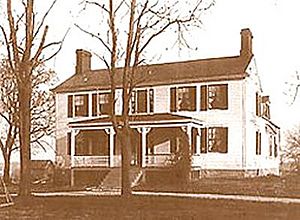
In 1839 James built a two-story weatherboard home, naming it "Fairfax" after a family friend in Maryland, Albert Kirby Fairfax, Lord Fairfax of Cameron. A year later the property was divided between James and John Marshall when James married Elizabeth Kyle McCausland (she is related to The Robert Campbell Family of St Louis thru the Kyle's). Fairfax was completed the following year. James and Elizabeth had five children who lived to maturity. A son, Ernest, the only to marry and have children, raised two sons.
James Marshall sought to build a church and requested the services of the Presbyterian Church of St. Louis, which sent Rev Artemus Bullard to assist Marshall in 1845. A Presbyterian congregation was established in Rock Hill in March 1845, and met in a log house on Marshall's property while the church was built on land contributed by Marshall for a church. Though there is no written proof, it is assumed by many that slaves built the church using stone quarried from the Marshall farm quarry. Rev. Bullard gave the church the name "Rock Hill Presbyterian Church," presumably after two geographic features in the area, which became the namesake of the area. In 1866 fifteen members separated to found the Webster Groves Presbyterian Church
Marshall served as first postmaster at Fairfax House c. 1845. Marshall died in February 1864. The post office was closed in 1863, only to reopen a year later until 1897, whereupon mail service was moved to Webster Groves.
Mail service was re-established in February 1874.
Rock Hill was a stop near present-day Creve Coeur Drive on the Missouri Pacific spur from Creve Coeur, Missouri to downtown St. Louis. Trains ran twice daily. In 1934 Rock Hill Investment Co. purchased 22.93 acres on the railroad from Rock Hill Supply Co. for an industrial subdivision In 1954 Walter F. Hellmich purchased 15 acres to develop an "Industrial Court." In 1969 Rock Hill notified Missouri Pacific it would condemn its station.
Rock Hill remained largely undeveloped until the 1920s when much of the area was parceled for the construction of houses. In 1940 a 27-acre subdivision was created south of Manchester road. In April 1929 Rock Hill was incorporated as a village. The village switched to a mayor–aldermanic form of government in 1941. In April 1947 the Village of Rock Hill voted to incorporate as a fourth class city.
On 10 February 1959 a powerful tornado struck Rock Hill north of Manchester, destroying Mackle Florist (1913–1965) and continued onward into St. Louis.
In April 1962 the city voted to annex the eastern half of Des Peres Avenue.
The city flag was presented by the Citizens of Rock Hill Improvement Association in May 1965.
In 2006 Rock Hill began transitioning from a residential city to a point-of-sale city with a retail development project on Manchester. With city financial reserves at critical levels, city administrator George Liyeos told the Post-Dispatch "our entire future hinges on the success of that project."
The 30th annual Rock Hill Fall Festival was held in 2013.
Demographics
Historical population | |||
---|---|---|---|
Census | Pop. | %± | |
1930 | 1,309 | — | |
1940 | 1,821 | 39.1% | |
1950 | 3,847 | 111.3% | |
1960 | 6,523 | 69.6% | |
1970 | 6,815 | 4.5% | |
1980 | 5,702 | −16.3% | |
1990 | 5,217 | −8.5% | |
2000 | 4,765 | −8.7% | |
2010 | 4,635 | −2.7% | |
2020 | 4,750 | 2.5% | |
U.S. Decennial Census |
2020 census
As of 2020, there were 4,750 people living in the city.
2010 census
As of the census of 2010, there were 4,635 people, 2,064 households, and 1,198 families residing in the city. The population density was 4,252.3 inhabitants per square mile (1,641.8/km2). There were 2,217 housing units at an average density of 2,033.9 per square mile (785.3/km2). The racial makeup of the city was 70.6% White, 23.0% African American, 0.3% Native American, 2.5% Asian, 0.8% from other races, and 2.9% from two or more races. Hispanic or Latino of any race were 2.8% of the population.
There were 2,064 households, of which 26.6% had children under the age of 18 living with them, 42.3% were married couples living together, 11.8% had a female householder with no husband present, 3.9% had a male householder with no wife present, and 42.0% were non-families. 33.8% of all households were made up of individuals, and 9% had someone living alone who was 65 years of age or older. The average household size was 2.25 and the average family size was 2.93.
The median age in the city was 36.9 years. 20.7% of residents were under the age of 18; 7.1% were between the ages of 18 and 24; 32.9% were from 25 to 44; 26.8% were from 45 to 64; and 12.6% were 65 years of age or older. The gender makeup of the city was 49.0% male and 51.0% female.
Business
In business since 1890, Trainwreck Saloon on Manchester is the oldest continually operated bar in St. Louis County.
Business first developed east of Deer Creek. Windom was the Rock Hill area serviced by railroad east of the river bounded by Brentwood Boulevard and Litzinger Road. Windom stop, later "Mentor", had a post office where mail was delivered weekly. West of Deer Creek a number of dairy and produce farms developed.
The Hacienda restaurant building on Manchester Road was the home built by steamboat captain Mils T. Redmon in 1861. In 1951 the house became a restaurant called Chalet De Normandie, owned by the Ledait family, and later Parente's Italian Village. In 1968, it was St. Louis' first full-service Mexican eatery. It was called Oliver's until 1977, when it became Hacienda.
In July 1997 Landside Resources Inc. began constructing McKnight Crossing, a $5.5 million 40,000-square-foot mixed-use space anchored by Hollywood Video. In April Landside had agreed to purchase the Fairfax House from the Rock Hill Improvement Association and pay for its restoration and relocation across the road to Rock Hill Presbyterian Church.
In May 1999 the Board of Alderman selected Sansone Development over Landside Resources for redevelopment of McKnight and Manchester. In October Sansone withdrew from the project. Sansone told Rock Hill later that year it wanted to scale back the development area from 25 acres to 16, just the northwest corner. After the city reopening the bid process Rock Hill agreed in April 2000 to allow Sansone to develop 16 acres, financed by up to $7 million in tax-increment financing. Sansone withdrew its proposal again in September 2000 citing city delays that meant surrounding development projects had progressed so much as to make the 16-acre proposal infeasible. The city re-bid the projects and received 40-acre plans from Regency Realty and THF Realty and an additional 25-acre plan from Regency. In April 2001 both developers retracted their bids amid a firestorm of resident opposition against the proposals.
In 2001 RSI Kitchen & Bath purchased the three-acre former Stivers car dealership property on Manchester for construction of its main showroom. In December 2000 Quebecor World began talks with city officials to acquire the city hall for a potential expansion of the adjacent Sayers Printing Company. In August 2002 Quebecor World Sayers closed its 3.5-acre property.
In January 2004 the Board of Aldermen selected Novus Companies to develop 36.9 acres at the southwest and northwest corners of Manchester and McKnight roads. In March 2005 the Board of Aldermen approved the $95 million mixed-use development, called Market at McKnight. The buy-out area targeted 126 properties on the north corner, and 48 properties, including 15 homes, on the south side. Demolition began in August 2006. In May 2007 Rock Hill sought a second request for proposals when over half of north-side property owners were unsatisfied with Novus' buy-out offers and Novus sought an additional $7 million in tax increment financing (TIF). In December 2007 the Board of Alderman replaced Novus with Miller Weingarten and Hutkin Properties on the northwest redevelopment site and increased the TIF from $18 million to $26.7 million. The south Market at McKnight opened in November 2007. By January 2010 the development area was 60 percent leased. In April 2014 Novus announced its second anchor for the development, 27,000-square-foot Lucky's Market.
In June 2005 the Board of Aldermen approved Mills Properties' request to build an 84-unit apartment complex on 7.7 acres on McKnight Road.
In 2006 Rock Hill joined the Webster Groves/Shrewsberry Area Chamber of Commerce.
In December 2008 Target delayed its plans for a store on the northwest development by nine months, citing the global credit crisis. In March 2009 Target canceled its planned location. Miller Weingarten ended its involvement in May. The 27-acre north development area was reduced to 2.9 acres in October 2010.
In 1986 The Book House was established on Manchester Road. In 2009 the three-story Victorian house received a Historic Buildings designation from the Rock Hill Historic Preservation Commission. In May 2013 Book House owner Michelle Barron received an eviction notice from property owner Rex Stahl who wanted to redevelop the 1.5-acre property, site of two other businesses. In October the Board of Alderman approved EZ Storage's proposal to build a 107,772-square-foot storage facility on the site. The Book House reopened in Maplewood in 2014.
Education
Since 1948 Rock Hill has been part of the Webster Groves School District. Three public schools are within the city's borders:
- Hudson Middle school
- Hudson Elementary School
- Webster Groves givens elementary
Rock Hill School District comprised Rock Hill, parts of Ladue, Warson Woods, Kirkwood, Brentwood and Webster Groves; and was one of the first districts formed in St. Louis County. Rock Hill #I on Manchester and Rock Hill Road was established in 1909. In 1911 enrollment was 270. In 1912 two more elementary schools were built. In 1920 Rock Hill #II passed on to Brentwood when the city split from Rock Hill School District to form its own school district. Rock Hill #I was expanded with a three-story addition in 1930, the same year Rock Hill #III was razed. In 1945 ten acres were purchased for construction of a junior high school, later also a senior high school, which is today Hudson Elementary School. It was designed by Ernest J. Friton. In July 1948, voters opted to merge the district with Webster Groves School District. The Webster Groves School Board accepted the merge in September. Enrollment in Rock Hill School District was 435 at the time. Rock Hill superintendent T. Dean Adams was named as principal of Rock Hill's two schools. Rock Hill #I was renamed after long-time Rock Hill school board president Ed Schall. The NAACP sued and won the right for students on the north side of Lithia Avenue to attend Schall after schools were legally integrated in 1956.
In May 1958, Webster Groves School District voters passed a bond issue for the construction of a $1.6 million junior high school in Rock Hill and a second junior high school abutting Webster Groves Senior High School. Steger Junior High, named after Webster Groves Superintendent Leonard Steger, was built in 1960. Steger was converted to an elementary school amid budget cuts in 1978 as part of a district-wide reorganization plan. In 1983 the school district finalized plans to consolidate sixth grade teaching at Steger.
Schall School was rebuilt in 1965, then transferred to Special School District of St. Louis County in 1975. Enrollment was 172. Hudson was closed in 1978 and reopened in 1984 after remodeling. Schall was made a Department of Motor Vehicles office circa 1982.
- Rock Hill Preschool
From c. 1974 Rock Hill Preschool operated out of the Parks and Recreation building on North Rock Hill Road. In March 2007 the city eliminated the preschool program as a cost-saving measure. Mayor Morgan voted against the preschool the next month when a second aldermanic vote came down to a tie.
Parks, recreation and historical landmarks
The recreation program was set in motion in 1971 by mayor Lincoln Wagner. In June 1972 mayor Jess Stroup created a citizen parks and recreation commission to build a city park. One of the recreation commission's first acts was to create a summer day camp program for children. By October 1974 the city signed a contract to begin construction of a half-acre park. Dedicated in June 1975, the two-acre park had two tennis courts, two handball courts, two shuffleboard courts and horseshoe pits. In 1976 the city hired Genie Zakrzewski to direct the parks and recreation program. By June 1982, the city had added four more parks:
- Oakhaven Park – Three-acre park on Gilbert & Oakhaven completed in 1977. Two lots for the park were purchased in 1974 and 1975. Built with four tennis courts, a picnic shelter, horseshoe pits and a playground.
- Oak Trail Nature Park – Four-acre park at the end of Oakhaven with 2000 feet of trails. Developed in 1979.
- Stroup Field – On Old Warson and McKinley. The land for this two-and-a-half-acre park was purchased around 1978. It initially included two softball fields and a soccer/football field.
- Greenwood Park – Located between Lithia and Eldridge. Sub-acre park that initially included a basketball court and playground.
The five parks cost $325,000 to build, with three quarters of the amount coming from federal and state programs.
After the Rock Hill Parks and Recreation building was demolished, the tennis courts at Rock Hill park remained until the park was closed and dismantled in 2017.
Two additional parks have also been built:
- Hensley Park – Next to Salem Hills
- Whitfield Park – Berry Road & Madison Avenue
Over half of residents had visited a city park in that last year, according to a 2009 survey commissioned by the city. Seventy-six percent of respondents felt the parks needed improvements. Oakhaven Park was the most used, followed by Stroup Field.
The Rock Hill Presbyterian Church was built by slaves in 1847 at what is now Manchester and McKnight roads. It was the oldest operating Presbyterian church west of the Mississippi River until 2010 when its congregation left. The United African Presbyterian Church congregation occupied the building until 2011 when the Giddings-Lovejoy Presbytery sold the property to a gas station. In July 2011 the Board of Aldermen approved construction under the condition that the gas station owners attempt to rehome the church. In April 2012 Cedar Lake Cellars began moving the church at its own expense to its winery in Foristell, Missouri.
Three time capsules were buried on the church property between 1845 and 1958. The later two (from 1935 and 1958) were recovered and opened in May. The third, its location having never been recorded, was never found.
Civics groups
- Rock Hill Improvement Association
The Rock Hill Improvement Association was formed in 1938 to serve the "best interests" of the school district and city. In 1940 the association advocated for the creation of the fire department. In 1943 the association paid for the renovation of the second floor of the Fairfax House to house the library. The association met here weekly. Circa 1944 the Ladies Auxiliary of Rock Hill Improvement Association was established.
- Interested Citizens of Rock Hill Improvement Association
The Interested Citizens association was formed by black Rock Hill residents in October 1963. The group litigated against commercial rezoning of neighborhoods. The association presented the city's flag design in 1965.
See also
In Spanish: Rock Hill (Misuri) para niños