
Rocksprings, Texas facts for kids
Quick facts for kids
Rocksprings, Texas
|
|
|---|---|
|
town
|
|

Historic Rocksprings Hotel
|
|

Location of Rocksprings, Texas
|
|
 |
|
| Country | United States |
| State | Texas |
| County | Edwards |
| Area | |
| • Total | 1.22 sq mi (3.15 km2) |
| • Land | 1.22 sq mi (3.15 km2) |
| • Water | 0.00 sq mi (0.00 km2) |
| Elevation | 2,402 ft (732 m) |
| Population
(2020)
|
|
| • Total | 874 |
| • Density | 716/sq mi (277.5/km2) |
| Time zone | UTC-6 (Central (CST)) |
| • Summer (DST) | UTC-5 (CDT) |
| ZIP code |
78880
|
| Area code(s) | 830 |
| FIPS code | 48-62816 |
| GNIS feature ID | 1345423 |
Rocksprings is a small town in Texas, United States. It is the main town, or county seat, of Edwards County, Texas. In 2020, about 874 people lived there. The town got its name from natural springs that flow from the limestone rocks in the area.
Contents
Discovering Rocksprings' Past
Rocksprings was founded in 1891 by J. R. Sweeten. He chose the spot because of the nearby natural springs. In the same year, the town got its own post office. It also became the county seat, meaning it was the center for local government. The first courthouse building in Rocksprings burned down in 1897. By 1914, the town had grown to about 500 people.
A Difficult Time in History
In the early 1900s, there were often conflicts between different groups of people in the area. One sad event happened in Rocksprings involving a young Mexican man named Antonio Rodriguez. He was accused of a crime and was killed by a group of white people. This event was reported widely and caused protests in Mexico. It was part of a series of violent acts during that time.
The Great Tornado of 1927
On April 12, 1927, a very powerful F5 tornado hit Rocksprings. It was so strong that it destroyed 235 out of 247 buildings in the town. This terrible storm killed 74 people and injured 205 others. This was almost one-third of everyone living in Rocksprings at the time.
Exploring Rocksprings' Location
Rocksprings is located in the northeast part of Edwards County. It sits on top of a large area called the Edwards Plateau. The town covers about 3.1 square kilometers (1.2 square miles) of land.
Main Roads and Travel
U.S. Route 377 goes right through the middle of Rocksprings. This road can take you northeast to Junction (about 46 miles away) or southwest to Del Rio (about 76 miles away). Texas State Highway 55 also passes through Rocksprings. It can lead you northwest to Sonora (about 55 miles away) or south to Uvalde (about 68 miles away).
Rocksprings' Climate
The weather in Rocksprings usually has hot, humid summers. Winters are generally mild to cool. This type of weather is known as a humid subtropical climate.
Rocksprings' Economy and Jobs
The main part of Rocksprings' economy is based on the wool and mohair industry. Mohair comes from Angora goats. Rocksprings is even known as the "Angora goat capital of the world"!
Recently, Tourism has also become important for the town. Many visitors come to see the Devil's Sinkhole State Natural Area. This amazing natural spot is about 8 miles northeast of Rocksprings.
People of Rocksprings
The number of people living in Rocksprings has changed over the years.
- In 1930, there were 998 people.
- By 1950, the population grew to 1,436.
- In 2000, it was 1,285.
- In 2010, the population was 1,182.
- By 2020, it was 874 people.
Learning in Rocksprings
The town of Rocksprings is served by the Rocksprings Independent School District. Students attend Rocksprings High School. The school's sports teams are called the Angoras, and their mascot is Rocko, the fighting Angora billy goat!
Rocksprings in Pop Culture
Rocksprings was featured in two episodes of the TV show Brooklyn Nine-Nine. In the show, it was the fictional location of the Texas State Penitentiary, Spring Valley Unit.
Photo gallery
-
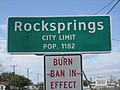
Entrance sign to Rocksprings, burn ban in effect in 2011
-
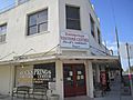
Rocksprings Visitor Center arranges tours of the nearby Devil's Sinkhole State Natural Area.
-
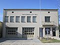
Rocksprings City Hall
-
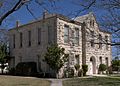
Edwards County Courthouse
-
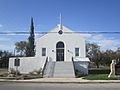
First Methodist Church in Rocksprings


See also
 In Spanish: Rocksprings (Texas) para niños
