Rogersville, Alabama facts for kids
Quick facts for kids
Rogersville, Alabama
|
|
|---|---|

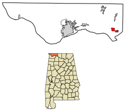
Location of Rogersville in Lauderdale County, Alabama.
|
|
| Country | United States |
| State | Alabama |
| County | Lauderdale |
| Area | |
| • Total | 3.03 sq mi (7.86 km2) |
| • Land | 3.03 sq mi (7.86 km2) |
| • Water | 0.00 sq mi (0.01 km2) |
| Elevation | 646 ft (197 m) |
| Population
(2020)
|
|
| • Total | 1,286 |
| • Density | 424.00/sq mi (163.71/km2) |
| Time zone | UTC-6 (Central (CST)) |
| • Summer (DST) | UTC-5 (CDT) |
| ZIP code |
35652
|
| Area code(s) | 256 |
| FIPS code | 01-66216 |
| GNIS feature ID | 2407235 |
Rogersville is a small town in Lauderdale County, Alabama, United States. In 2020, about 1,286 people lived there.
Contents
Rogersville History and Beginnings
Rogersville became an official town on February 2, 1858. It was first called "Rodgersville." The town got its name from Andrew and Patience Rodgers. They moved to the area from South Carolina. In 1818, they bought land that is now the center of town.
When the Rogersville Post Office opened in 1825, the 'd' was dropped from the name. Since then, it has been known as Rogersville.
How Rogersville Became a Trading Hub
Rogersville became an important place for trading. This was because it was located near three old roads. These roads were U.S. 72, Snake Road, and Lamb's Ferry Road.
- U.S. 72 used to be an old Indian trail. It helped people travel around a difficult part of the Tennessee River. Today, it connects Chattanooga and Memphis.
- Snake Road led to nearby Limestone County. It was a path from Florence to Athens. People used a shallow river crossing over the Elk River.
- Lamb's Ferry Road was named after John Lamb. He started a ferry across the Tennessee River in 1816. This ferry became a busy river port. Boats from places like Knoxville would unload supplies there. These supplies were then taken by land to areas like Pulaski, TN.
Rogersville's Location and Area
Rogersville is located in Alabama. It sits at specific coordinates: 34.823444 degrees North and 87.285693 degrees West. The town covers a total area of about 3.1 square miles (7.86 square kilometers). All of this area is land.
Rogersville's Population Over Time
| Historical population | |||
|---|---|---|---|
| Census | Pop. | %± | |
| 1870 | 435 | — | |
| 1880 | 61 | −86.0% | |
| 1920 | 397 | — | |
| 1930 | 445 | 12.1% | |
| 1940 | 508 | 14.2% | |
| 1950 | 531 | 4.5% | |
| 1960 | 766 | 44.3% | |
| 1970 | 950 | 24.0% | |
| 1980 | 1,224 | 28.8% | |
| 1990 | 1,125 | −8.1% | |
| 2000 | 1,199 | 6.6% | |
| 2010 | 1,257 | 4.8% | |
| 2020 | 1,286 | 2.3% | |
| U.S. Decennial Census 2013 Estimate |
|||
Rogersville's Population in 2010
In 2010, there were 1,257 people living in Rogersville. These people lived in 555 homes. About 24.7% of homes had children under 18. The average age of people in Rogersville was 43 years old.
Rogersville's Population in 2020
| Race | Num. | Perc. |
|---|---|---|
| White (non-Hispanic) | 1,117 | 86.86% |
| Black or African American (non-Hispanic) | 65 | 5.05% |
| Native American | 5 | 0.39% |
| Asian | 10 | 0.78% |
| Pacific Islander | 2 | 0.16% |
| Other/Mixed | 54 | 4.2% |
| Hispanic or Latino | 33 | 2.57% |
By 2020, the population of Rogersville had grown slightly to 1,286 people. There were 603 households in the town.
Education in Rogersville
Students in Rogersville attend schools in the Lauderdale County School District. The main high school for the area is Lauderdale County High School.
Famous People from Rogersville
Some notable people have come from Rogersville:
- Susan Parker – She was the 37th State Auditor for Alabama.
- Larry Woods – He used to play in the NFL.
- Robert Woods – He also played in the NFL as an offensive tackle.
See also
 In Spanish: Rogersville (Alabama) para niños
 | Delilah Pierce |
 | Gordon Parks |
 | Augusta Savage |
 | Charles Ethan Porter |

