Rolling Hills Estates, California facts for kids
Quick facts for kids
Rolling Hills Estates, California
|
||
|---|---|---|

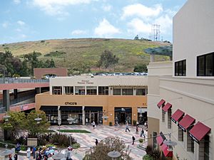
Promenade on the Peninsula mall, Rolling Hills Estates
|
||
|
||

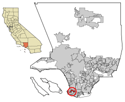
Location of Rolling Hills Estates in Los Angeles County, California
|
||
| Country | ||
| State | ||
| County | Los Angeles | |
| CCD | Palos Verdes | |
| Incorporated | September 18, 1957 | |
| Government | ||
| • Type | Council-Manager | |
| Area | ||
| • Total | 3.63 sq mi (9.41 km2) | |
| • Land | 3.60 sq mi (9.32 km2) | |
| • Water | 0.04 sq mi (0.09 km2) 1.22% | |
| Elevation | 469 ft (143 m) | |
| Population
(2020)
|
||
| • Total | 8,280 | |
| • Density | 2,281/sq mi (879.9/km2) | |
| Time zone | UTC−8 (PST) | |
| • Summer (DST) | UTC−7 (PDT) | |
| ZIP Codes |
90274–90275
|
|
| Area code(s) | 310 | |
| FIPS code | 06-62644 | |
| GNIS feature IDs | 1661326, 2410987 | |
Rolling Hills Estates is a city in Los Angeles County, California, United States. It is located on the northern side of the Palos Verdes Peninsula, facing the city of Torrance. Rolling Hills Estates is mostly a residential area, meaning it has many homes.
The city was officially formed, or incorporated, in 1957. It is known for its many horse paths, which are special trails for horses. In 2020, about 8,280 people lived in Rolling Hills Estates.
Contents
History of Rolling Hills Estates
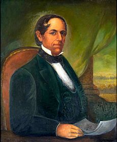
Rolling Hills Estates was once part of a very large piece of land called Rancho San Pedro. This land was owned by Manuel Dominguez, an important person who signed the first Californian Constitution.
Before it became Rolling Hills Estates, the area was sometimes known as Rancho El Elastico. On September 18, 1957, it officially became the 60th city in Los Angeles County.
Geography and Landslides
Rolling Hills Estates is found on the Palos Verdes Peninsula. This area is known for its beautiful views. The city covers about 3.6 square miles (9.3 square kilometers). A very small part of this area is water.
Understanding the Peartree Lane Landslide
The northern side of the Palos Verdes Peninsula, where Rolling Hills Estates is located, has a history of landslides. A landslide happens when a large amount of earth or rock moves down a slope.
On July 8, 2023, a landslide happened on Peartree Lane in Rolling Hills Estates. This event damaged several homes in the city. Experts believe this landslide might have started in 2022.
Population and People
| Historical population | |||
|---|---|---|---|
| Census | Pop. | %± | |
| 1960 | 3,941 | — | |
| 1970 | 6,735 | 70.9% | |
| 1980 | 7,701 | 14.3% | |
| 1990 | 7,789 | 1.1% | |
| 2000 | 7,676 | −1.5% | |
| 2010 | 8,067 | 5.1% | |
| 2020 | 8,280 | 2.6% | |
| 2022 (est.) | 8,018 | −0.6% | |
| U.S. Decennial Census | |||
The number of people living in Rolling Hills Estates has grown over the years. In 1960, there were about 3,941 residents. By 2020, the population had increased to 8,280 people.
Population in 2010
According to the 2010 US Census, Rolling Hills Estates had 8,067 residents. Most people lived in family homes. About 23.4% of the population was under 18 years old. The average age of residents was about 48.5 years.
Population in 2000
In the year 2000, the city had 7,676 people. About 24.3% of the population was under 18. The average age was 45 years.
Different Cultures in the City
Over the years, many different groups of people have moved to Rolling Hills Estates. For example, many Korean Americans moved to the Palos Verdes Peninsula in the 1980s and 1990s. This made the city more diverse.
Education
Rolling Hills Estates is part of the Palos Verdes Peninsula Unified School District. This district manages the public schools in the area.
There are also private schools in the city:
- Rolling Hills Country Day School (for students from kindergarten to 8th grade)
- Chadwick School (for students from kindergarten to 12th grade)
The Palos Verdes Library District has a library in Rolling Hills Estates called the Peninsula Center Library. It's a great place to find books and learn new things.
Economy and Jobs
The economy of Rolling Hills Estates includes various businesses and organizations that provide jobs for its residents.
Main Employers
Here are some of the biggest employers in Rolling Hills Estates, based on a 2009 report:
| # | Employer | # of Employees |
|---|---|---|
| 1 | Palos Verdes Peninsula Unified School District | |
| 2 | Equinox Fitness | 115 |
| 3 | Pavilions | 100 |
| 4 | Rolling Hills Country Club | 100 |
| 5 | Rolling Hills Covenant Church | 95 |
| 6 | Bristol Farms | 85 |
| 7 | Marmalade Café | 69 |
| 8 | CVS/pharmacy | 65 |
| 9 | Red Onion | 60 |
| 10 | Spectrum Athletic Clubs | 60 |
Shopping Areas
The city has two main shopping centers:
- The Promenade on the Peninsula mall: This mall used to be enclosed and had large department stores like May Company California.
- The Peninsula Center: This shopping area also had a department store called Buffums.
City Government and Services
Rolling Hills Estates is part of larger government areas.
- In the California State Legislature, the city is in the 26th Senate District, represented by Democrat Ben Allen for the State Senate and the 66th Assembly District, represented by Democrat Al Muratsuchi for the State Assembly.
- For the United States House of Representatives, Rolling Hills Estates is in California's 36th congressional district, represented by Democrat Raul Ruiz.
The Los Angeles County Sheriff's Department (LASD) helps keep the city safe. They operate the Lomita Station, which serves Rolling Hills Estates. The Los Angeles County Department of Health Services provides health services from the Torrance Health Center, which is also nearby.
See also
 In Spanish: Rolling Hills Estates para niños


