
Ross Island, South Andaman district facts for kids
.jpg) |
|

Ross Island, South Andaman district
Location in Andaman and Nicobar Islands

Ross Island, South Andaman district
Location in Bay of Bengal

Ross Island, South Andaman district
Location in India
Location of Netaji Subhas Chandra Bose Island
|
|
| Geography | |
|---|---|
| Location | Bay of Bengal |
| Coordinates | 11°40′30″N 92°45′47″E / 11.675°N 92.763°E |
| Archipelago | Andaman Islands |
| Adjacent bodies of water | Indian Ocean |
| Area | 0.312 km2 (0.120 sq mi) |
| Length | 1.25 km (0.777 mi) |
| Width | 0.52 km (0.323 mi) |
| Coastline | 3.20 km (1.988 mi) |
| Highest elevation | 45 m (148 ft) |
| Administration | |
| District | South Andaman |
| Island group | Andaman Islands |
| Island sub-group | Port Blair Islands |
| Tehsil | Port Blair |
| Largest settlement | INS Jarawa quarters |
| Demographics | |
| Population | 10 (2011) |
| Pop. density | 32 /km2 (83 /sq mi) |
| Ethnic groups | Indians, Andamanese |
| Additional information | |
| Time zone | |
| PIN | 744101 |
| Telephone code | 031927 |
| ISO code | IN-AN-00 |
| Literacy | 84.4% |
| Avg. summer temperature | 30.2 °C (86.4 °F) |
| Avg. winter temperature | 23.0 °C (73.4 °F) |
| Sex ratio | 1.2♂/♀ |
| Census Code | 35.639.0004 |
| Official Languages | Hindi, English |
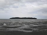
Ross Island, officially known as Netaji Subhash Chandra Bose Island, is a small island in the Andaman Islands. It is part of the South Andaman area in the Andaman and Nicobar Islands. The island is located about 3 kilometers (2 miles) east of central Port Blair. Its old ruins are a popular spot for tourists to visit.
Contents
Island's Name: Netaji Subhas Chandra Bose Island
Ross Island was first named after a marine surveyor, Daniel Ross. In December 2018, the island was renamed Netaji Subhas Chandra Bose Island. This was done to honor Netaji Subhas Chandra Bose, an important leader in India's fight for freedom.
Island's Past: A Look at History
Early Days of the Island
In 1789, Archibald Blair explored the Andaman and Nicobar Islands. After his survey, a settlement was started near what is now Port Blair. This settlement was moved in 1792 but was later abandoned in 1796. This was because many people got sick there. Between 1789 and 1792, Blair built a hospital and a place for sick people on Netaji Subhas Chandra Bose Island.
The Penal Settlement Period
About 60 years later, the British decided to set up a prison colony in the Andaman Islands. In 1858, they moved the prison from Singapore to Port Blair. This happened after the 1857 Revolt. Captain (Dr.) James Pattison Walker arrived in Port Blair on March 6, 1858. He brought 773 prisoners and four officials from Singapore.
Ross Island became the main office for the islands until 1945–1946. It was left empty after the British took it back. Netaji Subhas Chandra Bose visited the island from December 29 to 31, 1943, when the Japanese were in control.
Today, you can still see the ruins of many old British buildings. These include a bakery, stores, a water treatment plant, a church, a tennis court, a printing press, and a hospital. There are also remains of the Chief Commissioner's home, with its large gardens and ballrooms. These ruins remind us of the island's past.
In January 1858, the British took control of three islands around Port Blair. Captain H. Man raised the Union Jack flag. In March, J.P. Walker arrived with officials, doctors, guards, and 773 prisoners. They found that there was not enough water in Port Blair. So, Walker moved the main base to Netaji Subhas Chandra Bose Island.
The island quickly became the center of the prison colony. At first, prisoners lived in simple huts made of bamboo and grass. Later, they built houses, offices, and other buildings for the colony. The main house for the Chief of the Penal Settlement was built on the northern part of the island. It was called Government House.
In 1872, the leader of the settlement became known as the Chief Commissioner. Sir Donald Martin Stewart was the first Chief Commissioner. He was in charge from July 1872 to June 1875. After him, 24 more chief commissioners served on the island.
The island's role as the main center ended during the time of Charles Francis Waterfall. He became Chief Commissioner in 1938. The Japanese captured him in March 1942 when they took over the Andaman and Nicobar Islands during World War II.
The 1941 Earthquake
About nine months before the Japanese took over, Netaji Subhash Chandra Bose Island had an earthquake. The British started leaving the Andaman Islands not because of the earthquake, but because they expected the Japanese to invade during World War II. Ross Island was not left empty right after the earthquake. Netaji Subhas Chandra Bose and other important people stayed on the island until 1947. The island was abandoned after the British took it back, just before India became independent.
Japanese Control of the Island
From 1942 to 1945, the Japanese army controlled the island. The Government House became the home of the Japanese admiral for three years. During this time, Subhas Chandra Bose visited the island for a day in December 1943. He was working with the Japanese to fight against the British. Netaji also raised the Indian national flag on top of the Government House. The Japanese also left their mark on the island. You can still see bunkers they used as watch points to protect the island from attacks.
Recapturing the Island
In 1945, the Allied forces took back the island. After that, they left it empty.
In April 1979, the island was given to the Indian Navy. They set up a small base called INS Jarawa. It was named after one of the native tribes of the Andaman Islands.
Renaming in 2018
On December 30, 2018, Prime Minister Narendra Modi announced a new name for Ross Island. It was officially renamed Netaji Subhas Chandra Bose Island.
Island Location: Geography
Netaji Subhas Chandra Bose Island is part of the Port Blair Islands. It is located at the entrance of Port Blair.
Island Management: Administration
From a political point of view, Netaji Subhas Chandra Bose Island is part of the Port Blair Taluk.
Island Lighthouse
There is a path that leads to the northern end of the island. Here, a new concrete lighthouse tower was built in 1977. It is 10 meters (33 feet) tall and stands on a rock about 50 meters (164 feet) from the shore. You can reach the tower when the tide is low. This lighthouse was the first in India to use solar panels to power its light.
Island Wildlife: Fauna
Netaji Subhas Chandra Bose Island has thick forests. It might look like there are no people living there. However, the island is home to many animals. You can mostly find Spotted Deer and peacocks on the island. The island is also full of palm and coconut trees.
Island Population: Demographics
The Naval authorities do not allow civilians to live on the island.
Image gallery
-
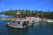
Netaji Subhas Chandra Bose Island (Andaman)
-
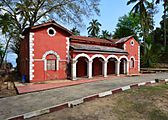
Bakery from the British era
-
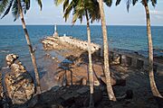
Old harbor and lighthouse
-
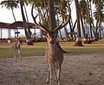
Free-roaming spotted deer
-
View of Netaji Subhas Chandra Bose Island from the Water Sports Complex, Port Blair
-
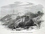
The Ross Island Prison Headquarters, 1872


