Rostrum Peak facts for kids
Quick facts for kids Rostrum Peak |
|
|---|---|

Rostrum Peak
|
|
| Highest point | |
| Elevation | 3,284 m (10,774 ft) |
| Prominence | 704 m (2,310 ft) |
| Parent peak | Christian Peak (3406 m) |
| Geography | |
| Location | British Columbia, Canada |
| Parent range | Canadian Rockies |
| Topo map | NTS 82N14 |
| Geology | |
| Age of rock | Cambrian |
| Type of rock | sedimentary rock |
| Climbing | |
| First ascent | 1936 W.N.M. Hogg, Christian Hasler Jr |
| Easiest route | Mountaineering |
Rostrum Peak is a tall mountain in the Canadian Rockies. It stands 3,284 meters (10,774 feet) high. You can find it in British Columbia, Canada. This peak is the highest point of the Bush Mountain area.
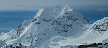
The mountain got its name in 1918. It was named "Rostrum" because it looks like a speaker's platform. A rostrum is a raised stage where someone gives a speech. The name was made official in 1924. The first people to climb Rostrum Peak were W.N.M. Hogg and Christian Hasler Jr. They reached the top in 1936.
Contents
About Rostrum Peak
Rostrum Peak is part of a huge mountain range. Its closest taller neighbor is Christian Peak. That mountain is about 13.5 kilometers (8.4 miles) away. Another peak, Icefall Peak, is about 2 kilometers (1.2 miles) to the northwest.
How Rostrum Peak Formed
Rocks and Layers
Rostrum Peak is made of sedimentary rock. This type of rock forms from layers of sand, mud, and tiny bits of plants and animals. These layers built up over millions of years. They were laid down in shallow seas.
Mountain Building
Long, long ago, these rock layers were pushed up. This happened during an event called the Laramide orogeny. This was a time when huge forces in the Earth's crust caused mountains to rise. The older rock layers were pushed over younger ones. This is how Rostrum Peak got its shape.
Weather and Climate
Cold and Snowy
Rostrum Peak is in a subarctic climate zone. This means it has very cold, snowy winters. Summers are usually mild. Temperatures can drop below −20 °C (−4 °F). With wind, it can feel even colder, sometimes below −30 °C (−22 °F).
Water Flow
The snow and ice that melt from the peak become runoff. This water flows into small streams. These streams then join larger rivers, like the Valenciennes River.


