Rowena, Oregon facts for kids
Quick facts for kids
Rowena, Oregon
|
|
|---|---|
|
Census-designated place (CDP)
|
|

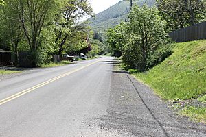
Modern Rowena, Oregon along U.S. Route 30
|
|

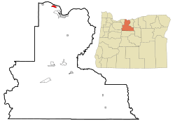
Location of Rowena, Oregon
|
|
| Country | United States |
| State | Oregon |
| County | Wasco |
| Area | |
| • Total | 1.81 sq mi (4.68 km2) |
| • Land | 1.81 sq mi (4.68 km2) |
| • Water | 0.00 sq mi (0.00 km2) |
| Elevation | 801 ft (244 m) |
| Population
(2020)
|
|
| • Total | 192 |
| • Density | 106.25/sq mi (41.02/km2) |
| Time zone | UTC-8 (Pacific (PST)) |
| • Summer (DST) | UTC-7 (PDT) |
| ZIP code |
97058
|
| Area code(s) | 458 and 541 |
| FIPS code | 41-63950 |
| GNIS feature ID | 2409219 |
Rowena is a small place in Wasco County, Oregon, United States. It's called an "unincorporated community" because it doesn't have its own local government like a city. For counting people, the United States Census Bureau calls it a "census-designated place" (CDP). This means it's a specific area they count, even if locals might think of the area a bit differently. In 2020, about 192 people lived there.
Rowena is located in a beautiful spot west of The Dalles. It sits right by the Columbia River, where the river flows through a natural narrow area called Rowena Gap. Two important roads, Interstate 84 and U.S. Route 30, pass through this community. Route 30 is famous for its curvy sections known as the Rowena Loops.
Contents
The Name of Rowena
The exact reason for Rowena's name is a bit of a mystery! Some people say it was named after H.S. Rowe. He was an official for a railroad company in the early 1880s.
Another story suggests it was named for a girl named Rowena. She was living in the area when the community was first started. It's also possible the name came from a character named Rowena. She is a lover in the famous novel Ivanhoe by Sir Walter Scott.
Rowena's History and Nature
Long ago, there was a ferry that carried people and goods across the Columbia River. This ferry connected Rowena with Lyle, Washington, on the other side.
Today, there's a special nature area near Rowena. It's called the Tom McCall Preserve. This preserve is on a flat area (plateau) and is managed by The Nature Conservancy. It's well-known for its amazing spring wildflowers. The preserve works together with Mayer State Park to protect this beautiful natural space.
Rowena's Geography
Rowena is a small area. According to the United States Census Bureau, the entire area of this CDP is about 1.81 square miles (4.68 square kilometers). All of this area is land, with no water within its official boundaries.
People Living in Rowena
| Historical population | |||
|---|---|---|---|
| Census | Pop. | %± | |
| 2020 | 192 | — | |
| U.S. Decennial Census | |||
In 2010, there were 187 people living in Rowena. These people lived in 77 households, and 51 of those were families. The population density was about 98 people for every square mile.
Most of the people living in Rowena were White. A small number of people were of Asian or Pacific Islander descent, or from other racial backgrounds. The average age of people in Rowena was about 41 years old. The number of males and females was almost equal.
See also
 In Spanish: Rowena (Oregón) para niños
 | Jackie Robinson |
 | Jack Johnson |
 | Althea Gibson |
 | Arthur Ashe |
 | Muhammad Ali |

