
Ruckersville, Virginia facts for kids
Quick facts for kids
Ruckersville, Virginia
|
|
|---|---|
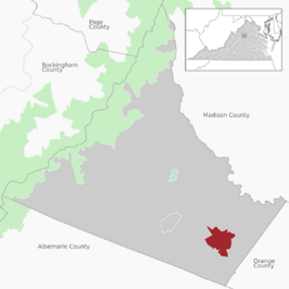 Location of the Ruckersville CDP within Greene County
|
|

Ruckersville, Virginia
Location in Virginia

Ruckersville, Virginia
Location in the United States
|
|
| Country | |
| State | |
| County | Greene |
| Founded | 1732 |
| Area | |
| • Total | 7.19 km2 (2.78 sq mi) |
| • Land | 7.13 km2 (2.75 sq mi) |
| • Water | 0.06 km2 (0.02 sq mi) |
| Elevation | 181 m (594 ft) |
| Population
(2010)
|
|
| • Total | 1,141 |
| • Estimate
(2020)
|
1,321 |
| • Density | 160.1/km2 (415/sq mi) |
| Time zone | UTC-5 (EST) |
| • Summer (DST) | UTC-4 (EDT) |
| ZIP code |
22968
|
| Area code(s) | 434 |
| FIPS code | 51-69360 |
| GNIS feature ID | 1498463 |
Ruckersville is a small community in Greene County, Virginia, United States. It is located in a countryside area just north of Charlottesville.
In 2020, about 1,321 people lived here. This was a good increase from the 1,141 people counted in 2010. Ruckersville is surrounded by hills, mountain views, trees, and farms. It sits where two main roads meet: U.S. Route 29 (running north-south) and U.S. Route 33 (running east-west). The town was started in 1732 by the same family who also founded Ruckersville, Georgia.
Contents
History of Ruckersville
Ruckersville was first settled by John Rucker. He named the village after his uncle, Captain John Rucker. His uncle helped choose the spot for St. Mark’s Parish Church in 1732. At that time, this area was part of Orange County.
Early families moved here, including John White. In 1739, he received land from George II of Great Britain, the king at the time. This land was near a place called Swift Run Gap. Six years later, in 1745, John White bought more land north of Ruckersville. This land was close to the south branch of the Rapidan River.
A creek called White Run starts in Ruckersville. It is named after the White family. This creek joins another one, Rippin's Run, east of Burtonsville. There was also a river crossing, or ford, on the Rapidan River that was likely named after this family. During the American Civil War, soldiers used this ford to cross the river.
Ruckersville became part of Greene County in 1838. This happened when Greene County was created from the western part of Orange County.
Where is Ruckersville?
Ruckersville is located in the southeastern part of Greene County.
According to the U.S. Census Bureau, the total area of Ruckersville is about 7.2 square kilometers (2.8 square miles). A very small part of this area, about 0.06 square kilometers (0.02 square miles), is water.
Getting Around Ruckersville
Ruckersville has two important roads that pass through it: U.S. Route 29 and U.S. Route 33.
- U.S. Route 33 goes about 13 kilometers (8 miles) east to Gordonsville. It also goes about 24 kilometers (15 miles) west to Skyline Drive. Further west, it reaches Harrisonburg, which is about 61 kilometers (38 miles) away.
- U.S. Route 29 goes about 12 kilometers (7.5 miles) north to Madison. It continues about 47 kilometers (29 miles) north to Culpeper. If you head south on U.S. 29, you will reach Charlottesville in about 16 kilometers (10 miles).
People in Ruckersville
In 2010, there were 1,141 people living in Ruckersville. These people lived in 461 households, and 316 of these were families.
- About 30.6% of households had children under 18 living with them.
- Many households (52.5%) were married couples living together.
- About 26.5% of all households were made up of people living alone.
- The average household had about 2.48 people.
- The average family had about 2.93 people.
The median age in Ruckersville was 43.5 years old. This means half the people were younger than 43.5, and half were older.
Ruckersville Parkway Idea
In 2005, some local leaders suggested building a new road. They called it the "Ruckersville Parkway." This road would have connected Ruckersville directly to the southern part of Charlottesville. However, many people who lived in the area and city planners did not agree with the idea. Because of their concerns, the plan for the parkway was not approved.
See also
 In Spanish: Ruckersville (Virginia) para niños
