Ruston, Washington facts for kids
Quick facts for kids
Ruston, Washington
|
|
|---|---|

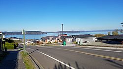
Neighborhoods at Stack Hill
|
|

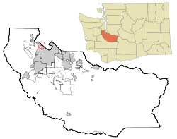
Location of Ruston, Washington
|
|
| Country | United States |
| State | Washington |
| County | Pierce |
| Area | |
| • Total | 0.26 sq mi (0.67 km2) |
| • Land | 0.26 sq mi (0.66 km2) |
| • Water | 0.00 sq mi (0.01 km2) |
| Elevation | 43 ft (13 m) |
| Population
(2020)
|
|
| • Total | 1,055 |
| • Density | 3,300.78/sq mi (1,276.60/km2) |
| Time zone | UTC-8 (Pacific (PST)) |
| • Summer (DST) | UTC-7 (PDT) |
| ZIP code |
98407
|
| Area code | 253 |
| FIPS code | 53-60510 |
| GNIS feature ID | 1512629 |
Ruston is a small city in Pierce County, Washington, United States. In 2020, about 1,055 people lived there.
Even though Ruston is very close to the larger city of Tacoma, it is still its own separate city. It used to be a "company town," meaning a town built and owned by a company for its workers. In 2012, the local government decided to officially call Ruston a city.
Contents
History of Ruston
How Ruston Began
In 1890, a businessman named William R. Rust started the Tacoma Smelting & Refining Company. He also created a town for his workers, which was called the "Smelter District." The company took over an older metal factory that had opened two years before.
By 1905, the company was refining lead and had more than 300 employees. Most of these workers lived in the Smelter District. In 1906, William Rust suggested creating a new city. The people living there decided to name it "Ruston" to honor him. Ruston officially became a city on November 10, 1906. It was surrounded by Commencement Bay on one side and the city of Tacoma on all other sides.
The ASARCO Smelter and Its Impact
In 1905, the American Smelting and Refining Company (ASARCO) bought the Tacoma Smelting & Refining Company. The Ruston factory then started smelting copper. In 1917, a very tall brick smokestack was built. It was originally 571 feet (174 meters) high, making it the tallest in the world at the time. After an earthquake in 1937, it was made a bit shorter, to 562 feet (171 meters).
The factory created waste material called slag, which was dumped into Commencement Bay to create more land. The smokestack also released smoke that polluted parts of Pierce County. The smelter closed in 1985 because copper prices dropped and new rules were made about pollution. About 700 people worked at the factory when it closed. The tall smokestack was taken down on January 17, 1993, as part of a big environmental cleanup effort.
Cleaning Up and Developing Ruston
The environmental cleanup, called a Superfund program, covered most of the town. This meant removing polluted soil from properties in and around Ruston. By 2006, most of the cleanup was finished. After the cleanup, home prices in Ruston doubled in just three years. Ruston became a popular place for people to live and travel to work in other cities.
In late 2012, the Ruston town council voted to change its official status to a "noncharter code city" under Washington state law. However, officials said they would still use the name "Town of Ruston."
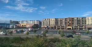
Development of new homes and shops on the 97-acre (39-hectare) former smelter site began in 2013. This area was renamed "Point Ruston." The first part of this new development opened in 2014. Point Ruston is now like a modern village with homes, shops, and a waterfront park. It also has a path that connects to Point Defiance Park. The full plan for Point Ruston includes 1,200 homes, a hotel by the water, and many different shops and businesses.
Geography of Ruston
Ruston is surrounded on three sides by the city of Tacoma. To the north, it borders Puget Sound.
The United States Census Bureau says that Ruston covers a total area of about 0.34 square miles (0.88 square kilometers). Most of this, about 0.26 square miles (0.67 square kilometers), is land. The rest, about 0.08 square miles (0.21 square kilometers), is water.
Population and People
| Historical population | |||
|---|---|---|---|
| Census | Pop. | %± | |
| 1910 | 780 | — | |
| 1920 | 1,128 | 44.6% | |
| 1930 | 818 | −27.5% | |
| 1940 | 739 | −9.7% | |
| 1950 | 838 | 13.4% | |
| 1960 | 694 | −17.2% | |
| 1970 | 668 | −3.7% | |
| 1980 | 612 | −8.4% | |
| 1990 | 693 | 13.2% | |
| 2000 | 738 | 6.5% | |
| 2010 | 749 | 1.5% | |
| 2020 | 1,055 | 40.9% | |
| U.S. Decennial Census 2020 Census |
|||
Ruston's Population in 2010
Based on the 2010 census, there were 749 people living in Ruston. These people lived in 336 households, and 194 of these were families. The population density was about 2,881 people per square mile (1,112 people per square kilometer). There were 430 housing units, with an average of 1,654 units per square mile (639 per square kilometer).
The people in Ruston were mostly White (87.0%). Other groups included African American (2.9%), Native American (1.1%), Asian (2.7%), and Pacific Islander (0.7%). About 0.9% were from other races, and 4.7% were from two or more races. People who identified as Hispanic or Latino made up 6.0% of the population.
About 28.0% of households had children under 18 living with them. About 43.8% were married couples living together. About 30.1% of all households were made up of people living alone. About 6.6% had someone living alone who was 65 years old or older. The average household had 2.23 people, and the average family had 2.78 people.
The average age in Ruston was 39.5 years. About 20.8% of residents were under 18. About 10% were 65 years old or older. The population was 48.7% male and 51.3% female.
Schools in Ruston
Ruston is part of the Tacoma Public Schools district. Most students in Ruston go to Point Defiance Elementary School. Some parts of eastern Ruston go to Sherman Elementary School. All students in Ruston attend Truman Middle School and Silas High School (which used to be called Woodrow Wilson High School).
The magnet school called the Science and Math Institute (SAMi) is next to Ruston, inside Point Defiance Park. This school opened in the park in 2009 and moved to a new campus in 2015.
See also
 In Spanish: Ruston (Washington) para niños
 | Selma Burke |
 | Pauline Powell Burns |
 | Frederick J. Brown |
 | Robert Blackburn |


