Saarpfalz District facts for kids
Quick facts for kids
Saarpfalz
|
||
|---|---|---|
|
||
 |
||
| Country | ||
| State | Saarland | |
| Capital | Homburg (Saar) | |
| Area | ||
| • Total | 418.53 km2 (161.60 sq mi) | |
| Population
(2002)
|
||
| • Total | 156,358 | |
| • Density | 373.589/km2 (967.590/sq mi) | |
| Time zone | UTC+1 (CET) | |
| • Summer (DST) | UTC+2 (CEST) | |
| Vehicle registration | HOM and IGB | |
| Website | saarpfalz-kreis.de | |
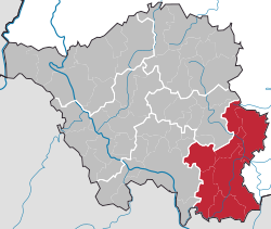
Saarpfalz (Saar-Palatinate) is a Kreis (district) in the south-east of the Saarland, Germany. Neighboring districts are (from west clockwise) Saarbrücken, Neunkirchen, Kusel, Südwestpfalz, district-free Zweibrücken, and the French département Moselle.
History
When after World War I the Saar area went under special government of the League of Nations, the Palatinate area, then part of Bavaria, was split in two parts. The part which went into the Saar became commonly known as Saarpfalz, and was administered by the two Bezirksamt: St. Ingbert and Homburg. The district Saarpfalz was created in 1974 when the two districts of Saint Ingbert and Homburg were joined. Since 1997 the district has a partnership with Henrico County, Virginia.
Coat of arms
 |
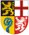
The lion in the top left is the symbol of the Palatinate (Pfalz), the cross in the top right is the symbol of Trier, both owned big part of the district in the past. The crosier is the bottom left represents the clerical possessions of the monasteries, while the silver lion in the bottom right is the symbol of the county of Homburg. |
Towns and municipalities
| Towns | Municipalities |
|---|---|
|
|

All content from Kiddle encyclopedia articles (including the article images and facts) can be freely used under Attribution-ShareAlike license, unless stated otherwise. Cite this article:
Saarpfalz District Facts for Kids. Kiddle Encyclopedia.

