
Sabanetas, Mayagüez, Puerto Rico facts for kids
Quick facts for kids
Sabanetas
|
|
|---|---|
|
Barrio
|
|

El Maní Beach at sunset
|
|

Location of Sabanetas within the municipality of Mayagüez shown in red
|
|

Sabanetas, Mayagüez, Puerto Rico
Location in Caribbean
|
|
| Commonwealth | |
| Municipality | |
| Area | |
| • Total | 8.30 sq mi (21.5 km2) |
| • Land | 6.46 sq mi (16.7 km2) |
| • Water | 1.84 sq mi (4.8 km2) |
| Elevation | 3 ft (0.9 m) |
| Population
(2010)
|
|
| • Total | 4,005 |
| • Density | 620/sq mi (240/km2) |
| Source: 2010 Census | |
| Time zone | UTC−4 (AST) |
Sabanetas is a neighborhood, called a barrio, located in the town of Mayagüez, Puerto Rico. In 2010, about 4,000 people lived there. It's a part of Puerto Rico, which is a commonwealth of the United States.
Contents
A Look Back at Sabanetas
Puerto Rico used to be controlled by Spain. After the Spanish–American War in 1898, Spain gave Puerto Rico to the United States. This was part of an agreement called the Treaty of Paris of 1898.
Because of this, Puerto Rico became an unincorporated territory of the United States. This means it's a part of the U.S. but not a state. In 1899, the U.S. government counted everyone living in Puerto Rico. This count, called a census, showed that 1,401 people lived in Sabanetas barrio.
| Historical population | |||
|---|---|---|---|
| Census | Pop. | %± | |
| 1900 | 1,401 | — | |
| 1980 | 3,418 | — | |
| 1990 | 3,794 | 11.0% | |
| 2000 | 4,161 | 9.7% | |
| 2010 | 4,005 | −3.7% | |
| U.S. Decennial Census 1899 (shown as 1900) 1910-1930 1930-1950 1980-2000 2010 |
|||
The Story Behind the Name
Sabanetas is a coastal area with rivers and open fields. It shares a border with the town of Añasco to the north. The name "Sabanetas" comes from the word "sabana," which means "plain" or "savanna."
These plains are found along the northern beaches of Mayagüez. They are near the Mona Channel and the mouth of the Río Grande de Añasco river. The "eta" part of "Sabanetas" means that these plains are not very big.
Sabanetas is special because it includes the hilly island of Desecheo. Desecheo has a Taíno name that means "hilly land." The area of Sabanetas is surrounded by the Caribbean Sea, the Goaorabo River, a swamp, a creek called La Boquilla, and the hills of Algarrobos and Miradero.
Cool Places to Visit in Sabanetas
Sabanetas is home to the El Maní community. You can find the El Mani Pavilion here. This building was used for handball events during the 2010 Central American and Caribbean Games. These games are a big sports event for countries in Central America and the Caribbean.
The Boquilla Creek Wildlife Reserve (Reserva Natural del Caño de la Boquilla) is also in Sabanetas. This is a protected area for wildlife. Another important natural area is the Desecheo National Wildlife Refuge. This refuge helps protect animals and plants on Desecheo Island.
The Eugenio María de Hostos Airport is a regional airport located within Sabanetas. It helps people travel to and from the area.
Images for kids
-
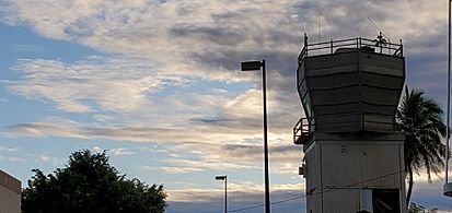
Eugenio Maria de Hostos Airport Tower in Sabanetas
-
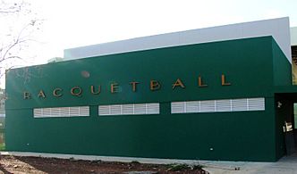
El Maní Pavilion


See also
 In Spanish: Sabanetas (Mayagüez) para niños
- List of communities in Puerto Rico
