Sabula, Iowa facts for kids
Quick facts for kids
Sabula, Iowa
|
|
|---|---|

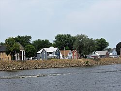
Sabula, Iowa from the Mississippi River
|
|

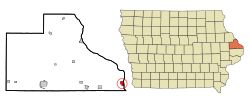
Location of Sabula, Iowa
|
|
| Country | |
| State | |
| County | Jackson |
| Incorporated | September 1864 |
| Area | |
| • Total | 1.46 sq mi (3.77 km2) |
| • Land | 0.49 sq mi (1.28 km2) |
| • Water | 0.96 sq mi (2.49 km2) |
| Elevation | 591 ft (180 m) |
| Population
(2020)
|
|
| • Total | 506 |
| • Density | 1,024.29/sq mi (395.21/km2) |
| Time zone | UTC-6 (Central (CST)) |
| • Summer (DST) | UTC-5 (CDT) |
| ZIP code |
52070
|
| Area code(s) | 563 |
| FIPS code | 19-69510 |
| GNIS feature ID | 0460877 |
Sabula is a small city in Jackson County, Iowa, United States. It's special because it's Iowa's only city located on an island! In 2020, about 506 people lived there. The island has a fun beach and a campground for visitors. There's also a harbor where boats can dock and be stored in winter. Sabula is the start of U.S. Route 67, a long highway that goes all the way to the border of the United States and Mexico.
Contents
A Look Back: Sabula's History
Sabula was first settled in 1835. A story says that a person named Isaac Dorman crossed the river on a log and decided to make Sabula his home. The name "Sabula" comes from a French word meaning "sand." This makes sense because the area has sandy soil.
How Sabula Became an Island City
For a long time, Sabula was not an island. It became an island in the 1930s. This happened when the Army Corps of Engineers built a system of locks and dams on the Mississippi River. When Lock and Dam No. 13 was built in 1939, the land west of Sabula became permanently flooded. This created the "Island City" that we know today.
Where is Sabula? Geography Facts

Sabula is located at 42°4′4″N 90°10′27″W / 42.06778°N 90.17417°W. The city covers about 1.26 square miles (3.26 square kilometers). Most of this area is water, with only about 0.40 square miles (1.04 square kilometers) being land.
Sabula is connected to the rest of Iowa by a road that crosses between two lakes. It's also connected to Savanna, Illinois, by a bridge that goes over the Mississippi River.
Who Lives in Sabula? Population Details
| Historical populations | ||
|---|---|---|
| Year | Pop. | ±% |
| 1850 | 168 | — |
| 1860 | 406 | +141.7% |
| 1870 | 920 | +126.6% |
| 1880 | 1,223 | +32.9% |
| 1890 | 918 | −24.9% |
| 1900 | 1,029 | +12.1% |
| 1910 | 918 | −10.8% |
| 1920 | 865 | −5.8% |
| 1930 | 759 | −12.3% |
| 1940 | 771 | +1.6% |
| 1950 | 888 | +15.2% |
| 1960 | 894 | +0.7% |
| 1970 | 845 | −5.5% |
| 1980 | 824 | −2.5% |
| 1990 | 710 | −13.8% |
| 2000 | 670 | −5.6% |
| 2010 | 576 | −14.0% |
| 2020 | 506 | −12.2% |
| Source: and Iowa Data Center Source: |
||
Sabula's Population in 2020
In 2020, the city of Sabula had 506 people living there. There were 261 households, which are groups of people living together. About 18.4% of these households had children under 18. Most residents were White (97.0%). The average age in Sabula was 54.3 years old. About 17.6% of the people were under 20, and 28.5% were 65 or older.
Sabula's Population in 2010
In 2010, Sabula had 576 people. There were 270 households. The racial makeup was mostly White (99.1%). About 24.8% of households had children under 18. The average age was 45 years. About 22.4% of residents were under 18, and 20.3% were 65 or older.
Learning in Sabula: Education
Sabula is part of the Easton Valley Community School District. This district was created in 2013 when two other school districts joined together. Sabula used to have its own school, which first opened in a settler's home in 1838. New school buildings were built in 1856 and 1883. The old Sabula school building was eventually closed and torn down in 2015.
Places of Worship: Religion in Sabula
Sabula has three churches:
- Sabula United Methodist Church, which started in 1839.
- St. Peter's Catholic Church, which dates back to the 1840s.
- Calvary Lutheran Church, built in 1944.
See also
 In Spanish: Sabula (Iowa) para niños
 | James B. Knighten |
 | Azellia White |
 | Willa Brown |

