St. Clair, Minnesota facts for kids
Quick facts for kids
St. Clair
|
|
|---|---|
| Motto(s):
"Roots rich in history, living for today, branching out for tomorrow"
|
|

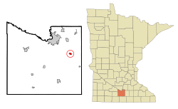
Location of St. Clair, Minnesota
|
|
| Country | United States |
| State | Minnesota |
| County | Blue Earth |
| Government | |
| • Type | Mayor - Council |
| Area | |
| • Total | 0.65 sq mi (1.68 km2) |
| • Land | 0.65 sq mi (1.68 km2) |
| • Water | 0.00 sq mi (0.00 km2) |
| Elevation | 978 ft (298 m) |
| Population
(2020)
|
|
| • Total | 750 |
| • Density | 1,155.62/sq mi (446.43/km2) |
| Time zone | UTC-6 (Central (CST)) |
| • Summer (DST) | UTC-5 (CDT) |
| ZIP code |
56080
|
| Area code(s) | 507/924 |
| FIPS code | 27-56824 |
| GNIS feature ID | 2396480 |
St. Clair is a small city in Blue Earth County, Minnesota, United States. It is located along the Le Sueur River. In 2020, about 750 people lived there. St. Clair is part of the larger Mankato-North Mankato metropolitan area.
Contents
Discovering St. Clair's Past
St. Clair was first known as Hilton. It was officially planned out in 1865. The city was later named St. Clair in honor of General James St. Clair. It became an official city in 1907.
Exploring St. Clair's Location
St. Clair is located in the state of Minnesota. The city covers a total area of about 0.65 square miles (1.68 square kilometers). All of this area is land, with no large bodies of water inside the city limits.
Main Roads in St. Clair
Two important roads help people get around St. Clair. These are Minnesota State Highway 83 and County Highway 15. They connect the city to other places nearby.
Understanding St. Clair's Population
The number of people living in St. Clair has changed over the years. Here is a look at the population from different years:
| Historical population | |||
|---|---|---|---|
| Census | Pop. | %± | |
| 1880 | 133 | — | |
| 1910 | 323 | — | |
| 1920 | 260 | −19.5% | |
| 1930 | 260 | 0.0% | |
| 1940 | 286 | 10.0% | |
| 1950 | 324 | 13.3% | |
| 1960 | 373 | 15.1% | |
| 1970 | 488 | 30.8% | |
| 1980 | 655 | 34.2% | |
| 1990 | 633 | −3.4% | |
| 2000 | 827 | 30.6% | |
| 2010 | 868 | 5.0% | |
| 2020 | 750 | −13.6% | |
| U.S. Decennial Census 2020 Census |
|||
Population Details from 2010
In 2010, there were 868 people living in St. Clair. These people lived in 303 households, and 225 of these were families. The city had about 1058 people per square mile.
Most of the people in St. Clair were White (97.1%). A small number were African American (1.2%), Native American (0.1%), or Pacific Islander (0.1%). About 1.5% of the population identified with two or more races. Around 3.1% of the people were Hispanic or Latino.
Many households (42.9%) had children under 18 living with them. Most households (61.4%) were married couples. About 20.1% of all households were made up of single individuals.
The average age of people in St. Clair was about 33.6 years old. About 31% of residents were under 18. About 8.5% were 65 years old or older. The population was almost evenly split between males (48.2%) and females (51.8%).
Learning in St. Clair
St. Clair has its own public school system. It is called St. Clair Public Schools. There is one main school building for all students. This building includes St. Clair Elementary School for students in kindergarten through 6th grade. It also has St. Clair Secondary School for students in 7th through 12th grade.
See also
 In Spanish: St. Clair (Minnesota) para niños

