
Saint Martin facts for kids
|
Nickname: The Friendly Island
|
|
|---|---|
 |
|
 |
|
| Geography | |
| Location | Caribbean Sea |
| Coordinates | 18°04′N 63°03′W / 18.067°N 63.050°W |
| Archipelago | Leeward Islands, Lesser Antilles, West Indies islands |
| Area | 87 km2 (34 sq mi) |
| Highest elevation | 414 m (1,358 ft) |
| Highest point | Pic Paradis |
| Administration | |
|
French Republic (France)
|
|
| Overseas collectivity | Saint Martin |
| Capital and largest settlement | Marigot (pop. 5,700) |
| Area covered | 53 km2 (20 sq mi; 60.9%) |
| Constituent country | Sint Maarten |
| Capital | Philipsburg |
| Largest settlement | Lower Prince's Quarter (pop. 8,123) |
| Area covered | 34 km2 (13 sq mi; 39.1%) |
| Demographics | |
| Demonym | St. Martinois (French); St. Maartener (Dutch) |
| Population | 77,741 (1 January 2009) |
| Pop. density | 892 /km2 (2,310 /sq mi) |
| Ethnic groups | Afro-Caribbean, European, Chinese, East Indian, and mixed |


Saint Martin is a beautiful tropical island in the northeast Caribbean Sea. It is about 300 kilometers (186 miles) southeast of Puerto Rico. The island is 87 square kilometers (34 square miles) in size.
What makes Saint Martin special is that it is divided between two countries. One part belongs to France and the other to the Netherlands. This makes it the smallest inhabited island in the world that is shared by two different nations.
About 60,000 people live on this unique island. The main towns are Marigot on the French side and Philipsburg on the Dutch side.
Contents
Two Countries, One Island
Saint Martin is split into two parts, each with its own government. This is a very interesting way for an island to be managed!
The Dutch Side: Sint Maarten
The southern part of the island is called Sint Maarten. It used to be part of the Netherlands Antilles. In October 2010, the Netherlands Antilles was dissolved. Sint Maarten then became a "country" within the Kingdom of the Netherlands.
- The government of the Netherlands is in charge of things like defense and foreign affairs for Sint Maarten.
- Even though Sint Maarten is part of the Kingdom of the Netherlands, it is not part of the European Union. However, its citizens are still considered Citizens of the European Union.
The French Side: Collectivity of Saint-Martin
The northern part of the island is called the Collectivité de Saint-Martin. This means it is an overseas territory of France.
- Being an overseas territory means it is governed by France.
- It has its own local government that works with France.
Exploring the Island's Towns
Both sides of Saint Martin have their own main towns. These towns are important centers for living and visiting.
Marigot: The French Capital
Marigot is the main town on the French side of Saint Martin. It is known for its charming French atmosphere.
- You can find lovely markets and shops here.
- The architecture often reminds visitors of France.
Philipsburg: The Dutch Capital
Philipsburg is the capital of the Dutch side, Sint Maarten. It is a busy port city.
- Many cruise ships visit Philipsburg.
- It has a lively boardwalk and duty-free shopping.
Images for kids
-
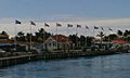
Flags flying in Marigot harbor, Saint-Martin
-
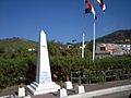
Crossing from St. Martin to Sint Maarten, dedicated in 2008
-
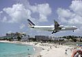
Air France Airbus A340 landing at Princess Juliana International Airport
-
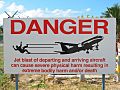
Sign warning people that standing too close to the airport fence on Maho Beach can be dangerous
-
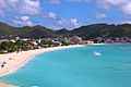
Simpson Bay, Sint Maarten, Dutch side
-
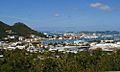
Philipsburg and the Great Bay
-
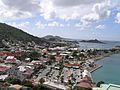
Marigot, Saint Martin, French side


