
Saint Thomas, U.S. Virgin Islands facts for kids

Charlotte Amalie, St. Thomas
|
|

St. Thomas
Location in the U.S. Virgin Islands
|
|
|
St. Thomas
Location in the U.S. Virgin Islands

St. Thomas
Location in Lesser Antilles

St. Thomas
Location in Caribbean
|
|
| Geography | |
|---|---|
| Location | Caribbean Sea |
| Coordinates | 18°20′N 64°55′W / 18.333°N 64.917°W |
| Archipelago | Virgin Islands, Leeward Islands |
| Area | 32 sq mi (83 km2) |
| Highest elevation | 1,555 ft (474 m) |
| Highest point | Crown Mountain |
| Administration | |
| Insular area | Virgin Islands |
| Largest settlement | Charlotte Amalie (pop. 18,481) |
| Demographics | |
| Demonym | Saint Thomian |
| Population | 51,634 (2010) |
| Pop. density | 638.17 /km2 (1,652.85 /sq mi) |

Saint Thomas (called Sankt Thomas in Danish) is a beautiful island in the Caribbean Sea. It's part of the Virgin Islands. Along with Saint John and Saint Croix, it forms a district of the United States Virgin Islands (USVI). The USVI is a territory of the United States.
The main city and capital of the USVI, Charlotte Amalie, is located on Saint Thomas. In 2010, about 51,634 people lived on Saint Thomas. This was almost half of the total population of the US Virgin Islands. The island covers an area of about 32 square miles.
Contents
Island History
Early Island Life
People first lived on Saint Thomas around 1500 BC. These early settlers were the Ciboney people. Later, other groups like the Arawaks and then the Caribs lived there. In 1493, Christopher Columbus saw the island during his second trip to the New World.
Danish Rule and Changes
The Dutch set up a trading post on Saint Thomas in 1657. Later, in 1671, the Danes successfully settled the island. Saint Thomas soon became a major place for trading enslaved people. The first ships carrying enslaved people arrived in 1673.
The island's land was divided into large farms called plantations. These plantations grew sugarcane, which became the main crop. The economy of Saint Thomas and nearby islands depended heavily on the labor of enslaved people. For a while, some of the biggest auctions of enslaved people in the world happened here.
In 1691, the main settlement on the island was named Charlotte Amalie. It was named after the wife of Denmark's King Christian V. The city later became a "free port." This meant ships could trade goods there without paying many taxes.
A small Jewish community grew in Charlotte Amalie starting in 1796. They built a historic synagogue, the St. Thomas Synagogue. It is the oldest synagogue in the United States that has been used continuously.
The British took over the island twice, once in 1801 and again from 1807 to 1815. After these times, the island was returned to Denmark.
Challenges and Changes
By the early 1800s, the sugar trade on Saint Thomas started to decline. Hurricanes, dry weather, and competition from the United States made it harder to grow and sell sugar. In 1848, slavery was ended. This caused labor costs to rise, which further hurt the sugar farms.
Because of its good harbors and defenses, Saint Thomas was still important. In the 1860s, the United States thought about buying the island from Denmark. However, the plan didn't get enough support.
Freedom and New Ownership
David Hamilton Jackson, a local islander, played a big role in the island's history. In 1915, he went to Denmark and convinced the King to allow freedom of the press on the islands. He started the first newspaper there, called The Herald. He also helped organize labor unions to improve working conditions for islanders. Today, there's an annual celebration in November to honor him.

In 1917, the United States bought Saint Thomas, along with Saint John and Saint Croix. The US paid $25 million in gold. This purchase was made to help protect the Panama Canal during World War I. The official transfer happened on March 31, 1917.
The United States gave citizenship to the island residents in 1927. In 1954, the islands officially became a US territory. This allowed them to form their own local government. Full self-governance was achieved in 1970.
After World War II, tourism grew a lot on the island. More people visited Saint Thomas, especially with cheaper air travel. Even after big hurricanes like Hurricane Hugo (1989) and Hurricanes Luis and Marilyn (1995), the island's facilities for visitors keep getting better.
Island Geography
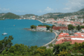
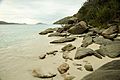
Saint Thomas has many natural bays and harbors. Some of these include Magens Bay, Great Bay, and Long Bay. Large passenger ships often dock in Long Bay, near Charlotte Amalie. Red Hook is a busy area on the east side of the island.
Island Climate
Saint Thomas has a warm, tropical climate all year round.
| Climate data for Saint Thomas, United States Virgin Islands | |||||||||||||
|---|---|---|---|---|---|---|---|---|---|---|---|---|---|
| Month | Jan | Feb | Mar | Apr | May | Jun | Jul | Aug | Sep | Oct | Nov | Dec | Year |
| Record high °F (°C) | 93 (34) |
93 (34) |
94 (34) |
96 (36) |
97 (36) |
99 (37) |
98 (37) |
99 (37) |
98 (37) |
97 (36) |
95 (35) |
92 (33) |
99 (37) |
| Mean daily maximum °F (°C) | 85.1 (29.5) |
85.1 (29.5) |
85.7 (29.8) |
86.7 (30.4) |
87.6 (30.9) |
89.1 (31.7) |
89.9 (32.2) |
90.2 (32.3) |
90.0 (32.2) |
88.7 (31.5) |
87.1 (30.6) |
85.6 (29.8) |
87.6 (30.9) |
| Mean daily minimum °F (°C) | 72.4 (22.4) |
72.3 (22.4) |
72.9 (22.7) |
74.1 (23.4) |
76.2 (24.6) |
77.7 (25.4) |
78.0 (25.6) |
78.1 (25.6) |
78.0 (25.6) |
76.9 (24.9) |
75.2 (24.0) |
73.7 (23.2) |
75.5 (24.2) |
| Record low °F (°C) | 63 (17) |
62 (17) |
56 (13) |
58 (14) |
66 (19) |
67 (19) |
57 (14) |
59 (15) |
64 (18) |
66 (19) |
52 (11) |
62 (17) |
52 (11) |
| Average precipitation inches (mm) | 2.16 (55) |
1.47 (37) |
1.05 (27) |
2.62 (67) |
3.05 (77) |
2.62 (67) |
2.82 (72) |
3.51 (89) |
4.82 (122) |
5.94 (151) |
6.00 (152) |
2.88 (73) |
38.95 (989) |
| Average precipitation days (≥ 0.01 in) | 14.3 | 11.8 | 8.1 | 10.7 | 11.9 | 11.1 | 14.8 | 14.2 | 14.6 | 17.7 | 17.8 | 16.7 | 163.6 |
| Source 1: NOAA (normals 1981−2010) | |||||||||||||
| Source 2: Weather Channel | |||||||||||||
Island Population
Saint Thomas is divided into several areas called subdistricts. Here are the populations for each area from the 2010 US Census:
- Charlotte Amalie (population 18,481)
- East End (population 8,403)
- Northside (population 10,049)
- Southside (population 5,411)
- Tutu (population 6,867)
- Water Island (population 182)
- West End (population 2,241)
Getting Around the Island

The island has its own airport, the Cyril E. King International Airport.
You can also take ferries from Saint Thomas to nearby islands. These include Water Island, Saint John, Saint Croix, and the British Virgin Islands. Ferries leave regularly from Red Hook and Charlotte Amalie.
One interesting fact about the US Virgin Islands is that people drive on the left side of the road. This tradition comes from when the Danes owned the islands. Even though most cars are brought from the United States mainland (where people drive on the right), the rule here is to drive on the left.
You'll find many taxis on the island, from small cars to large vans. There are also open-air trucks called "safaris" with bench seats. These safaris usually travel between popular spots like the cruise ship terminals and downtown Charlotte Amalie.
Images for kids
-
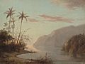
Camille Pissarro, A Creek in St. Thomas (Virgin Islands), 1856, National Gallery of Art. Pissarro was born on St. Thomas.
-
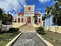
US Virgin Islands, Frederick Evangelical Lutheran Church was founded in 1666. The present structure was completed in 1793.
-
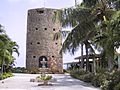
Blackbeard's Castle in Charlotte Amalie
-
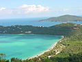
Magens Bay as seen from Drake's Seat, St. Thomas
-
View from Bluebeard's Castle, St. Thomas
-
Magens Bay
,_1856,_NGA_66427.jpg)


See also
 In Spanish: Santo Tomás (Islas Vírgenes) para niños
