
Hurricane Marilyn facts for kids
| Category 3 major hurricane (SSHWS/NWS) | |

Hurricane Marilyn on September 16, 1995
|
|
| Formed | September 12, 1995 |
|---|---|
| Dissipated | October 1, 1995 |
| Highest winds | 1-minute sustained: 115 mph (185 km/h) |
| Lowest pressure | 949 mbar (hPa); 28.02 inHg |
| Fatalities | 13 |
| Damage | $2 billion (1995 USD) |
| Areas affected | Leeward Islands, Barbados, Martinique, Dominica, Guadeloupe, U.S. Virgin Islands, Puerto Rico and Bermuda. |
| Part of the 1995 Atlantic hurricane season | |
Hurricane Marilyn was a very strong storm that hit the U.S. Virgin Islands in 1995. It was the fifteenth tropical depression and thirteenth named storm of the 1995 Atlantic hurricane season. Marilyn was the strongest storm to hit the Virgin Islands since Hurricane Hugo in 1989. It caused 13 deaths and more than $2 billion in damage.
Marilyn started forming on September 13, 1995. It quickly grew into a hurricane. On September 14, Marilyn reached the Lesser Antilles as a Category 1 hurricane. By the time it hit the U.S. Virgin Islands, it was a powerful Category 3 hurricane. After moving north past Bermuda, Marilyn became weaker. It changed into a different type of storm called an extratropical cyclone before it disappeared near Nova Scotia on October 1, 1995.
Contents
How Hurricane Marilyn Formed and Traveled

Hurricane Marilyn began as a tropical wave. This is like a ripple in the air that can grow into a storm. It formed off the coast of Africa in the eastern Atlantic Ocean around September 7-8. At first, it didn't have much convection, which means not many thunderstorms were forming.
The system slowly moved west for a few days. On September 12, it gained more thunderstorms and was named Tropical Depression Fifteen. It quickly got stronger, becoming Tropical Storm Marilyn just six hours later. Only four hours after that, it officially became Hurricane Marilyn.
For the next few days, Marilyn moved towards the northwest. It was a Category 1 hurricane when it passed about 45 nautical miles (83 km) north of Barbados. On September 14, Marilyn moved over Dominica and just southwest of Guadeloupe.
The hurricane kept moving and hit the U.S. Virgin Islands on September 15. Its winds were about 110 miles per hour (177 km/h) at this time. The center of the storm passed right over Saint Thomas. After passing over Puerto Rico, Marilyn was back over the Atlantic Ocean by September 16.

Marilyn then developed an "eye," which is the calm center of a hurricane. It reached its strongest point with winds of 115 miles per hour (185 km/h). This made it a major Category 3 hurricane. Some reports even said its winds might have been as high as 120-125 miles per hour (193-201 km/h).
After its peak, Marilyn started to weaken quickly. Its winds dropped from 141 miles per hour (227 km/h) to 102 miles per hour (164 km/h). This fast weakening happened because the storm's "eyewall" (the ring of strong thunderstorms around the eye) became weaker. Also, the waters it passed over were already disturbed by a previous storm, Hurricane Luis. Marilyn sped up towards Bermuda on September 18, passing about 150 nautical miles (278 km) west of the island on September 19.
By September 20, Marilyn had weakened from a hurricane to a low-pressure system. The remains of the storm continued over the central Atlantic Ocean for another 10 days before finally disappearing. Interestingly, a special "Hurricane Hunter" plane flying into the storm reported hail, which is very unusual for a tropical storm.
Getting Ready for the Storm

Many warnings were given as Marilyn approached. The first warnings were for Barbados, St. Vincent, and other islands on September 12. People were told a tropical storm was coming. Soon after, a tropical storm warning was issued for Trinidad and Tobago.
As Marilyn grew stronger, a Hurricane Warning was issued for islands like Barbados and St. Lucia on September 13. This meant a hurricane was expected to hit soon. On September 14, a hurricane watch was issued for Martinique. This meant a hurricane was possible.
Later, Puerto Rico, the U.S. and British Virgin Islands, and Guadeloupe were put under a hurricane warning. This meant people in these areas needed to prepare for a hurricane.
Over the next few days, some warnings were canceled as Marilyn moved away. But new warnings were issued for other areas. On September 15, the Dominican Republic was put under a hurricane watch. On September 16, the Turks and Caicos Islands and parts of the southeastern Bahamas were also put under a hurricane watch. These warnings were removed within two days.
Finally, on September 18, Bermuda was put under a Tropical Storm Watch, which was upgraded to a warning. This warning was removed the next day. In Barbados, about 250,000 people spent the night of September 13 in shelters to stay safe from the storm.
What Happened During and After the Storm
| Storm deaths by region | |
|---|---|
| Region | Direct deaths |
| St. Thomas | 5 |
| St. Croix | 1 |
| St. John | 1 |
| Puerto Rico | 1 |
| Unknown | 5 |
| Total | 13 (8) |
Hurricane Marilyn caused a lot of damage and 13 deaths in the United States Virgin Islands and Puerto Rico. Many areas received 4 to 7 inches (10 to 18 cm) of rain.
Impact in Guadeloupe
In Guadeloupe, some places received a huge amount of rain, over 20 inches (50 cm) in 12 hours! The strongest wind gust reported was 84 miles per hour (135 km/h) in Marie-Galante. Marilyn was one of three cyclones that affected this region in 1995.
Impact in the U.S. Virgin Islands

On St. Croix, the highest wind speed was 100 miles per hour (161 km/h). Some areas received over 11 inches (28 cm) of rain. The storm surge, which is when the ocean water rises above its normal level due to the storm, reached 6 to 7 feet (1.8 to 2.1 meters) in St. Thomas and St. Croix. One spot on St. Croix even saw a storm tide of 11.7 feet (3.6 meters).
Marilyn caused seven deaths in the U.S. Virgin Islands, mostly from people drowning on boats. About ten thousand people on St. Thomas lost their homes. Most buildings on the island were damaged in some way.
St. Thomas was hit the hardest. About 80% of homes and businesses were destroyed, including a hospital and the water plant. Five people died there. There was also serious damage on St. Croix and St. John.
Because of the severe damage, President Bill Clinton declared the U.S. Virgin Islands a federal disaster area. This made it possible for the government to send help and money for recovery.
Impact in Puerto Rico
In Puerto Rico, the highest rainfall from Marilyn was 5.60 inches (14.2 cm). The strongest wind gusts were 125 miles per hour (201 km/h) in Culebra. Marilyn passed over the islands of Vieques and Culebra, causing a lot of damage.
There were many reports of sudden floods across northern and eastern Puerto Rico. One person died in Culebra. President Bill Clinton also declared Puerto Rico a federal disaster area, so it could get federal aid. On Culebra Island, 100 homes were destroyed, and another 200 homes were damaged.
Impact in Other Areas
In Antigua, the highest wind gust was 50 miles per hour (80 km/h). The island had widespread flooding and damage to banana trees. Bermuda reported winds of 45 miles per hour (72 km/h) and gusts up to 60 miles per hour (97 km/h). In St. Maarten, winds were 42.5 miles per hour (68 km/h) with gusts up to 61 miles per hour (98 km/h). The British Virgin Islands had very little damage from Marilyn.
Helping After the Storm
Aid to Puerto Rico
After Hurricane Marilyn, relief supplies were sent to Puerto Rico and the U.S. Virgin Islands. Officials from FEMA (Federal Emergency Management Agency) set up camps on the islands. They gave out food, water, and supplies for shelter.
Aid to the U.S. Virgin Islands

On St. Thomas, 80% of homes were destroyed or damaged. Also, 20 to 30% of businesses were ruined. More than 2,100 government workers were sent to help clean up after Hurricane Marilyn.
Workers quickly started repairing buildings. Special Diving teams checked for damage in the harbors. The United States Navy Seabees, who are military construction workers, began fixing public buildings. The airport in St. Thomas was able to open for flights using a temporary control tower. The St. Thomas hospital was open, but it had to run on generators for power.
FEMA Disaster Recovery Centers opened on September 23 on St. Thomas. These centers helped people apply for aid. By October 11, about 1,500 loans were given for home repairs, mostly for small amounts of money. Many people applied for housing help, and thousands were approved.
Overall, Hurricane Marilyn caused about $1.5 billion (in 1995 money) in damage. It led to 13 deaths in its path.
Related pages
- List of Atlantic hurricanes
- Timeline of the 1995 Atlantic hurricane season
|
Tropical cyclones of the 1995 Atlantic hurricane season |
|||||||||||||||||||||||||||||||||||||
|
|
||||||||||||||||||||||||||||||||||||
|
|
|||||||||||||||||||||||||||||||||||||
Images for kids
-
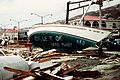
Beached sailboat on St. Thomas used as a billboard
-
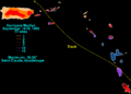
Marilyn Rainfall


