
Tobago facts for kids
Quick facts for kids
Tobago
Alloüebéra • Aloubaéra (Island Carib)
Urupina (Galibi Carib) |
|
|---|---|
|
Ward
|
|
| Ward of Tobago | |
| Etymology: Tabaco (transl. Tobacco) | |
 |
|
| Country | |
| Capital
and largest city
|
Scarborough 11°11′0″N 60°44′15″W / 11.18333°N 60.73750°W |
| Official languages | English |
| Vernacular language | Tobagonian English Creole |
| Ethnic groups
(2011)
|
|
| Religion
(2011)
|
|
| Demonym(s) | Tobagonian |
| Government | Autonomous administrative division |
|
• Chief Secretary
|
Farley Chavez Augustine |
|
• House Presiding Officer
|
Abby Taylor |
| Legislature | Tobago House of Assembly |
| National representation | |
|
• House of Representatives
|
2 MPs |
| Area | |
|
• Total
|
300 km2 (120 sq mi) |
| Population | |
|
• 2011 census
|
60,735 |
|
• Density
|
203/km2 (525.8/sq mi) |
| Currency | Trinidad and Tobago dollar (TTD) |
| Time zone | UTC-4 (AST) |
| Driving side | left |
| Calling code | +1 (868) |
Tobago is an island and a special region within the country of Trinidad and Tobago. It is located about 35 kilometers (22 miles) northeast of the larger island of Trinidad. Tobago is also about 160 kilometers (99 miles) off the northeastern coast of Venezuela. It lies to the southeast of the island of Grenada.
Contents
What Does the Name Tobago Mean?
When Christopher Columbus saw Tobago in 1498, he called it Belaforme. This name meant "beautiful" because it looked lovely from a distance.
The Kalina people, who lived on the mainland, called the island Urupina. They thought it looked like a big snail. The Island Caribs, also known as Kalinago, called it Aloubaéra. This name came from a giant snake they believed lived in a cave on the island of Dominica.
The name Tabaco was first used in 1511 by the Spanish. This name was inspired by the island's shape. It looked like the thick cigars smoked by the Taíno people of the Caribbean islands.
A Brief History of Tobago
Who Lived in Tobago First?
The first people to live in Tobago were the Ortoiroid people. They settled there between 3500 and 1000 BCE. Later, around the first century CE, the Saladoid people arrived. They brought new skills like making pottery and farming. They introduced crops such as cassava, sweet potatoes, and corn.
Later, the Barrancoid people also influenced Tobago's culture. After 650 CE, the Troumassoid culture became common. Tobago was an important meeting point for the Kalinago people from the Lesser Antilles and their Kalina friends in Guianas and Venezuela. In the 1630s, the Kalina people lived in Tobago.
Columbus saw Tobago in 1498 but did not land. Spanish settlers later raided the island to capture people. These raids continued until the 1620s and greatly reduced the island's population.
European Attempts to Settle Tobago

In 1628, Dutch settlers created the first European colony in Tobago. They called it Nieuw Walcheren. They also built a fort named Nieuw Vlissingen near today's Plymouth. The settlement was left empty in 1630 after attacks from local people. It was re-established in 1633.
However, the Spanish from Trinidad destroyed this new colony. This happened after the Dutch supported a local revolt in Trinidad. English attempts to settle Tobago in the 1630s and 1640s also failed because of resistance from the indigenous people.

The local population also stopped European settlement in the 1650s. Over the years, many European powers tried to control Tobago. These included the Curonians, Dutch, English, French, Spanish, and Swedish. Tobago changed hands 33 times, which is the most in Caribbean history. Finally, in 1814, the Treaty of Paris gave Tobago to the British.
In 1662, the Dutch brothers Adrian and Cornelius Lampsins became "Barons of Tobago." They ruled until the English took the island in 1666. Adrian briefly got Tobago back in 1673 but was killed in battle. The English, led by Sir Tobias Bridge, took control again.

From 1672 to 1674, during a time of British rule, Tobago became more stable. This is when large farms called plantations began. Factories for sugar, cotton, and indigo were built. Africans were brought by the British to work as slaves. The economy grew. France gave the island to Britain in 1763. By 1777, Tobago was exporting a lot of cotton, indigo, rum, and sugar.
In 1781, the French took the island back during the Invasion of Tobago.
British Rule and Independence
In 1814, Tobago became British again. Another period of successful sugar production began. But a strong hurricane in 1847, along with problems in the sugar industry, ended the sugar trade. Slavery had also ended in 1834, which changed the economy.
In 1889, Tobago became a part of Trinidad. Without sugar, islanders started growing other crops. They planted limes, coconuts, and cocoa, and sold them to Trinidad. In 1963, Hurricane Flora hit Tobago hard. It destroyed villages and crops. After this, a rebuilding plan started. Efforts were made to grow the economy in new ways. This is when the tourism industry began to develop.
Trinidad and Tobago gained independence from the British Empire in August 1962. It became a republic on August 31, 1976.
Geography of Tobago
.jpg)
Tobago is about 300 square kilometers (116 square miles) in size. It is about 40 kilometers (25 miles) long and 10 kilometers (6 miles) wide. It is located at 11° 15' North latitude and 60° 40' West longitude, just north of Trinidad.
Tobago is mostly hilly and mountainous. These mountains were formed by volcanoes. The southwest part of the island is flat and made of coral limestone. The main mountain range is called the Main Ridge. The highest point in Tobago is Pigeon Peak, which is 550 meters (1,804 feet) tall.
What is Tobago's Climate Like?
Tobago has a tropical climate. It is located just south of the Atlantic hurricane belt. This means it can sometimes be hit by tropical storms. The average rainfall changes across the island. It can be 3,800 millimeters (150 inches) on the Main Ridge. In the southwest, it is less than 1,250 millimeters (49 inches).
There are two main seasons:
- A wet season from June to December.
- A dry season from January to May.
| Climate data for Tobago (A.N.R. Robinson International Airport) (1973-2004) | |||||||||||||
|---|---|---|---|---|---|---|---|---|---|---|---|---|---|
| Month | Jan | Feb | Mar | Apr | May | Jun | Jul | Aug | Sep | Oct | Nov | Dec | Year |
| Record high °C (°F) | 32.4 (90.3) |
33.1 (91.6) |
33.2 (91.8) |
35.0 (95.0) |
34.0 (93.2) |
33.4 (92.1) |
33.0 (91.4) |
35.0 (95.0) |
33.8 (92.8) |
33.7 (92.7) |
32.8 (91.0) |
36.1 (97.0) |
36.1 (97.0) |
| Mean daily maximum °C (°F) | 30.2 (86.4) |
30.5 (86.9) |
30.9 (87.6) |
31.4 (88.5) |
31.7 (89.1) |
31.1 (88.0) |
30.7 (87.3) |
31.2 (88.2) |
31.5 (88.7) |
31.4 (88.5) |
30.9 (87.6) |
30.3 (86.5) |
31.0 (87.8) |
| Daily mean °C (°F) | 26.3 (79.3) |
26.5 (79.7) |
26.8 (80.2) |
27.6 (81.7) |
28.1 (82.6) |
27.6 (81.7) |
27.4 (81.3) |
27.6 (81.7) |
27.8 (82.0) |
27.6 (81.7) |
27.3 (81.1) |
26.7 (80.1) |
27.3 (81.1) |
| Mean daily minimum °C (°F) | 22.5 (72.5) |
22.5 (72.5) |
22.8 (73.0) |
23.9 (75.0) |
24.6 (76.3) |
24.2 (75.6) |
24.0 (75.2) |
24.0 (75.2) |
24.1 (75.4) |
23.9 (75.0) |
23.6 (74.5) |
23.0 (73.4) |
23.6 (74.5) |
| Record low °C (°F) | 19.0 (66.2) |
19.0 (66.2) |
19.2 (66.6) |
18.7 (65.7) |
21.0 (69.8) |
20.1 (68.2) |
21.0 (69.8) |
20.3 (68.5) |
20.0 (68.0) |
19.1 (66.4) |
19.2 (66.6) |
19.6 (67.3) |
18.7 (65.7) |
| Average precipitation mm (inches) | 65.9 (2.59) |
52.8 (2.08) |
21.4 (0.84) |
52.9 (2.08) |
105.8 (4.17) |
172.5 (6.79) |
266.9 (10.51) |
244.6 (9.63) |
182.6 (7.19) |
240.2 (9.46) |
207.5 (8.17) |
161.0 (6.34) |
1,774.2 (69.85) |
| Average precipitation days (≥ 1 mm) | 9.8 | 7.0 | 5.2 | 5.2 | 8.9 | 15.6 | 17.1 | 15.4 | 13.7 | 14.8 | 16.2 | 13.0 | 142.0 |
| Source: NOAA | |||||||||||||
How Hurricanes Affect Tobago
Because Tobago is near the hurricane belt, it has been hit by strong storms. Hurricane Flora in 1963 was very severe. It changed Tobago's economy a lot. The hurricane destroyed banana, coconut, and cacao farms. These farms were a big part of the economy. It also damaged the beautiful rainforest in the island's northern half.
Many farms were left empty after Flora. The economy then shifted from farming to tourism. Hurricane Ivan in 2004 also caused significant damage, though it was not as strong as Flora.
Government in Tobago

The Tobago House of Assembly (THA) manages both central and local government tasks in Tobago. The current leader is the Chief Secretary of Tobago, Farley Chavez Augustine. His party, the Progressive Democratic Patriots, holds 14 out of 15 seats in the Assembly. The Tobago Council of the People's National Movement, led by Ancil Dennis, holds one seat. This was decided in the December 2021 Tobago House of Assembly election.
Tobago has two representatives in the Parliament of Trinidad and Tobago. These are for the areas of Tobago East and Tobago West. The Tobago Council of the People's National Movement controls both seats. They won them in the 2015 and 2020 Trinidad and Tobago general election.
What are Tobago's Districts?
Historically, Tobago was divided into seven parishes. These were Saint Andrew, Saint David, Saint George, Saint John, Saint Mary, Saint Patrick, and Saint Paul. In 1768, each parish chose people to represent them in the Tobago House of Assembly.
In 1889, the British government made Tobago a "ward" of Trinidad. This meant that Tobago's local government ended. It became part of a single colony government with Trinidad. In 1945, Tobago was managed as one county of Trinidad.
In 1980, the Tobago House of Assembly was brought back. It now handles local government in Tobago. Under this system, Tobago has 15 local electoral districts. Each district elects one Assemblyman to the THA.
| No. | Electoral districts |
|---|---|
| 1 | Bagotelle / Bacolet |
| 2 | Belle Garden / Glamorgan |
| 3 | Bethel / New Grange |
| 4 | Bethesda / Les Coteaux |
| 5 | Bon Accord / Crown Point |
| 6 | Buccoo / Mt. Pleasant |
| 7 | Darryl Spring / Whim |
| 8 | Lambeau / Lowlands |
| 9 | Mason Hall / Moriah |
| 10 | Mt. St. George / Goodwood |
| 11 | Parlatuvier/L’Anse Fourmi/Speyside |
| 12 | Plymouth/Black Rock |
| 13 | Roxborough/Argyle |
| 14 | Scarborough/Mt. Grace |
| 15 | Signal Hill/Patience Hill |
People and Culture of Tobago
In 2011, Tobago's population was 60,874 people. The capital city, Scarborough, has a population of 17,537. While Trinidad has many different ethnic groups, most people in Tobago are of African descent. There is also a growing number of Trinidadians of East Indian descent and Europeans. Between 2000 and 2011, Tobago's population grew by 12.55 percent. This makes it one of the fastest-growing areas in Trinidad and Tobago.
What is the Ethnic Makeup of Tobago?
| Racial composition | 2011 |
|---|---|
| Afro-Trinidadians and Tobagonians | 85.2% |
| Dougla (Indian and Black) | 4.2% |
| Multiracial | 4.2% |
| Indo-Trinidadian and Tobagonian | 2.5% |
| White Trinidadian/Tobagonian | 0.7% |
| Native American (Amerindian) | 0.1% |
| Chinese | 0.08% |
| Arab (Syrian/Lebanese) | 0.02% |
| Other | 0.1% |
| Not stated | 2.6% |
What Religions are Practiced in Tobago?
| Religious composition | 2011 |
|---|---|
| Seventh-day Adventism | 16.26% |
| Pentecostalism/Evangelicalism/Full Gospel | 14.69% |
| Anglicanism | 12.80% |
| Spiritual Baptist | 10.56% |
| Roman Catholicism | 6.64% |
| Methodism | 4.93% |
| Moravian | 4.56% |
| Jehovah's Witnesses | 1.62% |
| Orisha-Shango | 1.52% |
| Hinduism | 0.67% |
| Baptists | 0.63% |
| Islam | 0.57% |
| Rastafari | 0.39% |
| Presbyterianism/Congregationalism | 0.18% |
| Other | 10.38% |
| Not Stated | 9.83% |
| None | 5.39% |
Economy and Tourism in Tobago
Tobago's economy mainly relies on tourism, fishing, and government spending. The government is the largest employer. The Tobago House of Assembly (THA) employs 62% of the people who work there.
Tourism is still growing. Beach and water-sports tourism is popular in the southwest, near the airport. Ecotourism is also becoming more important. This type of tourism focuses on the large protected forest in the center and north of the island. It also includes Little Tobago, a small island known for its nature.
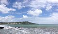
The tourist area in the southwest includes Crown Point, Store Bay, Buccoo Reef, and Pigeon Point. This area has wide sandy beaches and many resorts. Tobago has many beautiful beaches along its coast. Some popular ones are at Castara, Bloody Bay, and Englishman's Bay.
Tobago is connected to the world through the Arthur Napoleon Raymond Robinson International Airport. It also has the Scarborough harbor. Flights connect Tobago with Trinidad. International flights go to other Caribbean islands and Europe. There is also a daily fast ferry service between Port of Spain (in Trinidad) and Scarborough.
Tobago's economy is closely linked to Trinidad's. Trinidad's economy is based on natural gas, chemicals, and steel.
Diving in Tobago
Tobago is a popular place for diving. It is the southernmost Caribbean island with coral communities. Trinidad, which is further south, does not have much coral. This is because of low salt levels and a lot of silt from the Orinoco River in Venezuela.
Scuba diving in Tobago is often done around Speyside. This area is almost directly across the island from the airport. Tobago has some of the best diving spots in the Caribbean. There are three shipwrecks around its shores. The best one is usually considered to be the Maverick Ferry. This ferry used to travel between Trinidad and Tobago. It is 350 feet (107 meters) long and was sunk on purpose for divers. It lies 30 meters (98 feet) deep near Rocky Point, Mt. Irvine. The top of the wreck is 15 meters (49 feet) deep. The wreck is full of marine life, including a 4-foot (1.2-meter) jewfish. The waters around Tobago are home to many kinds of tropical fish, rays, sharks, and turtles.
Golf in Tobago
Tobago has two golf courses that visitors can use. The older one is the Mount Irvine Hotel Golf Course, built in 1968. It became famous after hosting the TV show "Shell's Wonderful World of Golf." The course is built among coconut trees. You can see the Caribbean Sea from almost every hole.
The other course is the Magdalena Grand Hotel & Golf Club. It was opened in 2001 and has hosted the European Seniors Tour three times.
Tobago in Art and Stories
Robinson Crusoe and Tobago
Tobago's size and location are similar to the island in the book Robinson Crusoe. In the story, the island is near Trinidad and the mouth of the Orinoco River. However, the book is usually thought to be based on the real experiences of Alexander Selkirk. He was stranded on an island in the Pacific Ocean, which was later named Robinson Crusoe Island. On Tobago, there is a place called Crusoe Cave.
Swiss Family Robinson Film
In 1958, the Walt Disney Company chose Tobago as the place to film Swiss Family Robinson. This movie was based on the book by Johann Wyss. When the filmmakers first saw the island, they "fell instantly in love." The movie needed many animals. They brought eight dogs, two giant tortoises, forty monkeys, two elephants, six ostriches, four zebras, one hundred flamingos, six hyenas, two anacondas, and one tiger from all over the world.
Filming locations included Richmond Bay (the Robinsons' beach), Mount Irvine Bay (the Pirates' beach), and the Craig Hall Waterfalls. The famous treehouse was built in a 200-foot tall saman tree in the Goldsborough Bay area. After filming, local people convinced Disney to leave the treehouse. It became a popular attraction. However, Hurricane Flora destroyed the structure in 1963. The tree is still there today. It is on the property of Roberts Auto Service and Tyre Shop in Goldsborough. Many people today do not know about the film or that it was made in Tobago.
Nature and Environment in Tobago

The Tobago Forest Reserve (Main Ridge Reserve) is the oldest protected rainforest in the Western Hemisphere. It has a lot of different plants and animals. It was made a protected area on April 17, 1776. This happened after Soame Jenyns, a Member of Parliament in Britain, suggested it. It has been protected ever since.
This forest has great biodiversity. This means it has many different kinds of living things. These include many species of birds (like the dancing blue-backed manakin), mammals, frogs, non-venomous snakes, butterflies, and other insects. Tobago also has beaches where leatherback turtles lay their eggs. They come ashore between April and July.
Tobago has several coral reef ecosystems. The Buccoo Reef, Culloden Reef, and Speyside Reef are the three largest coral reef systems. These reefs protect Tobago's shores from being washed away.
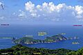
Little Tobago, a small island nearby, has some of the best dry forests left in Tobago. Little Tobago and St Giles Island are important places where seabirds nest. Birds like red-billed tropicbirds, magnificent frigatebirds, and Audubon's shearwaters live there.
Environmental Challenges
Recently, coral reefs have been damaged. This happened because of dirt and mud washing into the sea during road construction along the northeast coast. There has also been damage to the reef in Charlotteville village. This was caused by sealing a road at Flagstaff Hill. This sent more silty water down the stream to Charlotteville.
Famous People from Tobago
- The Mighty Shadow (Winston McGarland Bailey), a singer
- Kelly-Ann Baptiste, an Olympic sprinter
- Edwin Carrington, a politician
- Tracy Davidson-Celestine, a politician
- Winston Duke, an actor
- Lalonde Gordon, an Olympic sprinter
- Dominique Jackson, a model and actress
- A. P. T. James, a politician
- Buzz Johnson, a publisher
- Renny Quow, an Olympic sprinter
- Keith Rowley, a politician
- A. N. R. Robinson, a politician
- Calypso Rose (Linda Sandy-Lewis), a singer
- Faith B. Yisrael, a politician
- Dwight Yorke, a footballer
Images for kids
-
St Giles Island, northernmost part of Trinidad and Tobago, a bird sanctuary
-
Tobago - August 2013 (1530)
-
Tobago Cuisine - Crab and Dumplings
-
Panoramic shot of Downtown Scarborough, Tobago
-

Tobago Cuisine - Pacro Water and Sea Moss drinks
-
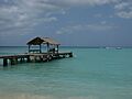
Pigeon Point, Tobago.
-
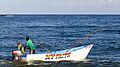
Fishing - Tobago, West Indies
-
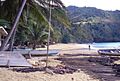
Castara village beach
.JPG)
.JPG)
.JPG)

.JPG)


See Also
 In Spanish: Tobago para niños
