Sakhalin facts for kids
 |
|
| Geography | |
|---|---|
| Location | Russian Far East, Pacific Ocean |
| Coordinates | 45°50' 54°24' N |
| Area rank | 23rd |
| Administration | |
|
Russia
|
|
| Demographics | |
| Population | 673,100 |
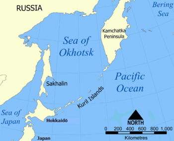
Sakhalin (Russian: Сахали́н Japanese: Karafuto (樺太) or Saharin (サハリン); Chinese: 庫頁/库页 Kùyè or 薩哈林/萨哈林 Sàhālín), also known as Saghalien, is a very large island in the North Pacific Ocean. It is part of Russia and is Russia's biggest island. Sakhalin is located between 45°50' and 54°24' North. It is managed as part of Sakhalin Oblast, which is like a state or province in Russia.
The original people who lived on Sakhalin Island are the Sakhalin Ainu, Oroks, and Nivkhs. Many Ainu people moved to Hokkaidō in Japan after 1949, when the Japanese left the island.
Sakhalin Island is famous because a well-known Russian writer, Anton Chekhov, wrote a whole book about it in 1895. This book has been printed many times in Russia and translated into English. Another interesting old book about the island is "To the Uttermost East" by Charles H. Hawes, published in 1904. Today, Sakhalin is experiencing a big boom in its oil industry.
Contents
Exploring Sakhalin Island
Sakhalin is a long island with a varied landscape. It has mountains, forests, and coasts. The island is known for its natural beauty and unique wildlife.
What is the Climate Like on Sakhalin?
The climate on Sakhalin Island is generally cold and snowy in winter, and mild in summer. It is influenced by the surrounding Sea of Okhotsk and the Pacific Ocean. This means the weather can change quickly.
Who Lives on Sakhalin Island?
The main group of people living on Sakhalin today are Russians. However, there are also many Koreans and the original groups like the Nivkhs, Oroks, Evenks, and Yakuts. These different groups have their own cultures and traditions, making the island a diverse place.
The Indigenous People of Sakhalin
The Ainu, Oroks, and Nivkhs are the native people of Sakhalin. They have lived on the island for a very long time. They have unique languages, customs, and ways of life that are connected to the island's environment.
What is the Economy of Sakhalin?
The economy of Sakhalin Island is mostly based on its natural resources. The biggest industry right now is oil and gas. There are large projects, like Sakhalin-2, that produce liquefied natural gas (LNG) and oil. Fishing and forestry are also important parts of the island's economy.
Oil and Gas Industry
The discovery of large oil and gas reserves around Sakhalin has brought a lot of development to the island. These projects create jobs and bring money to the region. They also involve building big facilities, like the LNG production plant.
History of Sakhalin Island
Sakhalin has a long and interesting history, with different countries claiming control over it at various times.
Early Maps and Explorers
For a long time, people weren't sure if Sakhalin was an island or connected to the mainland.
- In 1643, a Dutch explorer named De Vries explored parts of Sakhalin's eastern coast. He didn't realize it was an island.
- Later, in 1709, Jesuit missionaries gathered information that suggested Sakhalin existed, but they only mapped the northern half.
- In 1787, the French explorer La Perouse mapped most of the southwestern coast of Sakhalin. He heard the local people call it "Tchoka."
- It wasn't until 1810 that a Japanese explorer, Mamiya Rinzō, clearly described Sakhalin as an island on his map.
Who Controlled Sakhalin?
Over the centuries, both Russia and Japan had claims over Sakhalin.
- In the 19th century, both countries started to settle on the island.
- After the Russo-Japanese War in 1905, Sakhalin was divided. The southern part became Japanese territory, known as Karafuto Prefecture. The northern part remained Russian.
- After World War II in 1945, the entire island came under Russian control.
Wildlife and Nature of Sakhalin
Sakhalin Island is home to many different animals and plants. Its diverse landscapes, from mountains to coastlines, provide habitats for various species.
Animals of Sakhalin
The island's waters are home to marine animals like the Western Gray whale. On land, you can find various mammals and birds.
- Marine Life: The seas around Sakhalin are important feeding grounds for whales and other sea creatures.
- Insects: You can also find beautiful insects like the peacock butterfly on the island.
Plants of Sakhalin
Sakhalin has rich plant life, including forests and unique flowers.
- Wildflowers: Plants like Anaphalis margaritacea (also known as pearly everlasting) grow on the island.
Cities and Towns on Sakhalin
The largest city on Sakhalin Island is Yuzhno-Sakhalinsk. It was once called Toyohara when the Japanese controlled the southern part of the island.
Yuzhno-Sakhalinsk
Yuzhno-Sakhalinsk is the capital of Sakhalin Oblast. It is a modern city with a population of over 174,000 people. It has museums, like the Anton Chekhov museum, and is a center for business and culture on the island.
Images for kids
-
Historical extent of the Ainu people
-
De Vries (1643) mapped Sakhalin's eastern promontories without realising that he had visited an island (map from 1682).
See also
 In Spanish: Isla de Sajalín para niños
 | Madam C. J. Walker |
 | Janet Emerson Bashen |
 | Annie Turnbo Malone |
 | Maggie L. Walker |


