Salla facts for kids
Quick facts for kids
Salla
Kyelijävri
|
||
|---|---|---|
|
Municipality
|
||
| Sallan kunta Salla kommun |
||
 |
||
|
||

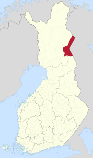
Location of Salla in Finland
|
||
| Country | ||
| Region | Lapland | |
| Sub-region | Eastern Lapland | |
| Charter | 1857 | |
| Area
(2018-01-01)
|
||
| • Total | 5,873.08 km2 (2,267.61 sq mi) | |
| • Land | 5,729.81 km2 (2,212.29 sq mi) | |
| • Water | 142.73 km2 (55.11 sq mi) | |
| Area rank | 7th largest in Finland | |
| Population
(2023-12-31)
|
||
| • Total | 3,344 | |
| • Rank | 207th largest in Finland | |
| • Density | 0.58/km2 (1.5/sq mi) | |
| Population by native language | ||
| • Finnish | 96% (official) | |
| • Swedish | 0.3% | |
| • Sami | 0.1% | |
| • Others | 3.6% | |
| Population by age | ||
| • 0 to 14 | 8.7% | |
| • 15 to 64 | 52% | |
| • 65 or older | 39.3% | |
| Time zone | UTC+02:00 (EET) | |
| • Summer (DST) | UTC+03:00 (EEST) | |
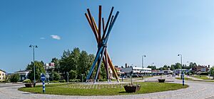
Salla is a town and municipality in Lapland, Finland. Until 1936, it was called Kuolajärvi. The local language of the Sami people calls it Kyelijävri.
Salla is home to about 3,344 people. It covers a large area of 5,873.08 square kilometres (2,267.61 sq mi). A small part of this area, 142.73 km2 (55.11 sq mi), is water. The town is not very crowded, with only about 0.58 inhabitants per square kilometre (1.5/sq mi) people per square kilometer.
Near Salla, you'll find Sallatunturi, which is famous for the Salla Ski Resort. It's a great place for winter sports!
Contents
History of Salla: A Border Town
Salla is located in Eastern Lapland, very close to the border. Because of its location, it was greatly affected by the Second World War.
Salla During the Winter War
During the Winter War in 1939, soldiers from the Red Army (Soviet Union) tried to enter Finland through Salla. However, the Finnish Army stopped them in a battle known as the Battle of Salla.
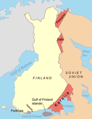
After the war, some parts of Salla were given to the Soviet Union. This area is sometimes called "Old Salla" or Vanha Salla.
Salla During the Continuation War
Later, during the Continuation War, the old town of Salla was on the Soviet side of the border. German soldiers, working with the Finnish 6th Division, attacked the Soviet positions. They managed to take back all the areas that Finland had lost.
At the end of the war, Finnish troops pushed the German soldiers out of Lapland in what was called the Lapland War.
Villages Given Away
The following villages from Salla were given to the Soviet Union:
- Alakurtti
- Korja (Korya)
- Kuolajärvi (Kuoloyarvi)
- Lampela
- Sallansuu
- Yläkurtti (Yulyakurtti)
- Sovajärvi (Sovayarvi)
- Tuutijärvi (Tuutiyarvi)
- Vuorijärvi (Vuoriyarvi)
Salla's Olympic Bid for Climate Change
In 2021, the mayor of Salla, Erkki Parkkinen, made a surprising announcement. He suggested that Salla should try to host the 2032 Summer Olympic Games. This was not a serious bid to host the games. Instead, it was a way to bring attention to climate change.
The mayor wanted to show how much the climate crisis threatens Salla. The town's nature and way of life depend on very cold temperatures for most of the year. By talking about the Olympics, Salla hoped to make more people aware of this important issue.
Transportation in Salla
Salla has a railway line that connects it to Kemijärvi. This line is currently only used for carrying goods. In 2006, there were talks about closing this railway line.
The railway used to go beyond Salla into Russia. However, it has never been used for travel between the two countries.
Geography of Salla
Salla is surrounded by several other towns. Its neighboring municipalities are Kemijärvi, Kuusamo, Pelkosenniemi, Posio, and Savukoski.
Climate in Salla
Salla has a subarctic climate. This means it has very long, cold winters and mild summers.
- Summers: Summer days are mild. It rains about one-third of the time, and nights are usually cool.
- Winters: Winters are very long and cold. They last from early October through April. There is a lot of snow, and the sky is often cloudy. It's rare for the weather to get warmer in the middle of winter. Very cold periods are common.
- Spring and Autumn: These seasons are short, lasting only a few weeks. They are usually cool and don't change much.
The coldest temperature ever recorded in Salla was -50 °C (-58 °F). This happened in Naruska in 1985. It was the coldest temperature ever recorded in Finland until 1999. On January 28, 1999, an even colder temperature of -54.3 °C (-65.7 °F) was unofficially recorded in Naruska.
| Climate data for Salla (1991–2020 normals, records 1961–present) | |||||||||||||
|---|---|---|---|---|---|---|---|---|---|---|---|---|---|
| Month | Jan | Feb | Mar | Apr | May | Jun | Jul | Aug | Sep | Oct | Nov | Dec | Year |
| Record high °C (°F) | 6.3 (43.3) |
6.2 (43.2) |
9.7 (49.5) |
17.5 (63.5) |
28.0 (82.4) |
30.3 (86.5) |
31.5 (88.7) |
31.0 (87.8) |
22.9 (73.2) |
14.5 (58.1) |
8.4 (47.1) |
4.9 (40.8) |
31.5 (88.7) |
| Mean maximum °C (°F) | 1.0 (33.8) |
1.3 (34.3) |
4.8 (40.6) |
11.5 (52.7) |
20.6 (69.1) |
24.9 (76.8) |
26.3 (79.3) |
24.2 (75.6) |
18.0 (64.4) |
9.5 (49.1) |
4.0 (39.2) |
2.0 (35.6) |
27.3 (81.1) |
| Mean daily maximum °C (°F) | −8.0 (17.6) |
−7.5 (18.5) |
−2.1 (28.2) |
3.8 (38.8) |
10.4 (50.7) |
16.6 (61.9) |
19.7 (67.5) |
16.8 (62.2) |
10.8 (51.4) |
2.8 (37.0) |
−2.5 (27.5) |
−5.6 (21.9) |
4.6 (40.3) |
| Daily mean °C (°F) | −12.0 (10.4) |
−11.6 (11.1) |
−6.9 (19.6) |
−0.7 (30.7) |
5.7 (42.3) |
11.7 (53.1) |
14.8 (58.6) |
12.1 (53.8) |
6.9 (44.4) |
0.3 (32.5) |
−5.3 (22.5) |
−9.1 (15.6) |
0.5 (32.9) |
| Mean daily minimum °C (°F) | −16.7 (1.9) |
−16.5 (2.3) |
−12.6 (9.3) |
−5.8 (21.6) |
0.7 (33.3) |
6.3 (43.3) |
9.5 (49.1) |
7.2 (45.0) |
2.9 (37.2) |
−2.6 (27.3) |
−8.5 (16.7) |
−13.1 (8.4) |
−4.1 (24.6) |
| Mean minimum °C (°F) | −32.9 (−27.2) |
−32.4 (−26.3) |
−28.4 (−19.1) |
−19.8 (−3.6) |
−7.1 (19.2) |
−0.9 (30.4) |
1.8 (35.2) |
−1.3 (29.7) |
−5.5 (22.1) |
−15.7 (3.7) |
−23.0 (−9.4) |
−28.9 (−20.0) |
−35.6 (−32.1) |
| Record low °C (°F) | −45.3 (−49.5) |
−46.3 (−51.3) |
−38.2 (−36.8) |
−30.8 (−23.4) |
−19.2 (−2.6) |
−6.7 (19.9) |
−1.5 (29.3) |
−6.5 (20.3) |
−15.2 (4.6) |
−29.7 (−21.5) |
−36.6 (−33.9) |
−40.2 (−40.4) |
−46.3 (−51.3) |
| Average precipitation mm (inches) | 37 (1.5) |
31 (1.2) |
31 (1.2) |
30 (1.2) |
41 (1.6) |
61 (2.4) |
77 (3.0) |
59 (2.3) |
54 (2.1) |
50 (2.0) |
40 (1.6) |
39 (1.5) |
550 (21.6) |
| Average precipitation days (≥ 0.1 mm) | 20 | 17 | 16 | 14 | 15 | 16 | 17 | 16 | 16 | 18 | 21 | 20 | 206 |
| Average relative humidity (%) | 87 | 86 | 80 | 73 | 68 | 68 | 74 | 80 | 85 | 90 | 92 | 89 | 81 |
| Source 1: FMI climatological normals for Finland 1991–2020 | |||||||||||||
| Source 2: record highs and lows | |||||||||||||
| Climate data for Salla Naruska (1991-2020 normals, extremes 1991–present) | |||||||||||||
|---|---|---|---|---|---|---|---|---|---|---|---|---|---|
| Month | Jan | Feb | Mar | Apr | May | Jun | Jul | Aug | Sep | Oct | Nov | Dec | Year |
| Record high °C (°F) | 6.2 (43.2) |
5.5 (41.9) |
9.0 (48.2) |
16.8 (62.2) |
28.2 (82.8) |
31.3 (88.3) |
30.5 (86.9) |
30.4 (86.7) |
23.0 (73.4) |
14.3 (57.7) |
7.9 (46.2) |
6.2 (43.2) |
31.3 (88.3) |
| Mean daily maximum °C (°F) | −8.4 (16.9) |
−7.8 (18.0) |
−2.2 (28.0) |
3.5 (38.3) |
10.1 (50.2) |
16.5 (61.7) |
19.5 (67.1) |
16.9 (62.4) |
10.8 (51.4) |
2.5 (36.5) |
−2.7 (27.1) |
−5.9 (21.4) |
4.4 (39.9) |
| Daily mean °C (°F) | −13.1 (8.4) |
−12.9 (8.8) |
−8.2 (17.2) |
−1.7 (28.9) |
4.8 (40.6) |
11.0 (51.8) |
13.9 (57.0) |
11.1 (52.0) |
6.2 (43.2) |
−0.3 (31.5) |
−5.9 (21.4) |
−9.9 (14.2) |
−0.4 (31.3) |
| Mean daily minimum °C (°F) | −18.5 (−1.3) |
−18.3 (−0.9) |
−14.8 (5.4) |
−7.5 (18.5) |
−0.4 (31.3) |
4.9 (40.8) |
7.9 (46.2) |
5.7 (42.3) |
1.4 (34.5) |
−3.4 (25.9) |
−9.3 (15.3) |
−14.4 (6.1) |
−5.6 (21.9) |
| Record low °C (°F) | −41.4 (−42.5) |
−41.8 (−43.2) |
−37.2 (−35.0) |
−31.8 (−25.2) |
−14.1 (6.6) |
−4.7 (23.5) |
−2.1 (28.2) |
−5.4 (22.3) |
−10.1 (13.8) |
−27.6 (−17.7) |
−35.1 (−31.2) |
−38.8 (−37.8) |
−41.8 (−43.2) |
| Source 1: https://www.ilmatieteenlaitos.fi/1991-2020-lampotilatilastot | |||||||||||||
| Source 2: https://kilotavu.com/fmi-tilastot.php?taulukkomoodi=true | |||||||||||||
| Climate data for Salla Värriötunturi (elevation 360m (1181 ft), 1991-2020 normals, extremes 1974–present) | |||||||||||||
|---|---|---|---|---|---|---|---|---|---|---|---|---|---|
| Month | Jan | Feb | Mar | Apr | May | Jun | Jul | Aug | Sep | Oct | Nov | Dec | Year |
| Record high °C (°F) | 4.0 (39.2) |
4.2 (39.6) |
7.4 (45.3) |
15.5 (59.9) |
25.8 (78.4) |
28.8 (83.8) |
30.0 (86.0) |
30.3 (86.5) |
21.7 (71.1) |
12.5 (54.5) |
6.7 (44.1) |
4.5 (40.1) |
30.3 (86.5) |
| Mean daily maximum °C (°F) | −8.2 (17.2) |
−8.1 (17.4) |
−3.7 (25.3) |
1.9 (35.4) |
7.9 (46.2) |
14.6 (58.3) |
18.0 (64.4) |
15.1 (59.2) |
9.1 (48.4) |
1.3 (34.3) |
−3.5 (25.7) |
−5.9 (21.4) |
3.2 (37.8) |
| Daily mean °C (°F) | −10.8 (12.6) |
−10.7 (12.7) |
−6.7 (19.9) |
−1.5 (29.3) |
4.0 (39.2) |
10.1 (50.2) |
13.6 (56.5) |
11.2 (52.2) |
6.1 (43.0) |
−0.7 (30.7) |
−5.6 (21.9) |
−8.3 (17.1) |
0.1 (32.2) |
| Mean daily minimum °C (°F) | −13.7 (7.3) |
−13.5 (7.7) |
−9.8 (14.4) |
−4.9 (23.2) |
0.5 (32.9) |
6.0 (42.8) |
9.7 (49.5) |
7.9 (46.2) |
3.5 (38.3) |
−2.6 (27.3) |
−7.9 (17.8) |
−10.9 (12.4) |
−3.0 (26.6) |
| Record low °C (°F) | −38.3 (−36.9) |
−31.1 (−24.0) |
−26.5 (−15.7) |
−19.0 (−2.2) |
−13.4 (7.9) |
−3.9 (25.0) |
−0.1 (31.8) |
−2.9 (26.8) |
−7.3 (18.9) |
−18.5 (−1.3) |
−27.6 (−17.7) |
−31.1 (−24.0) |
−38.3 (−36.9) |
| Average precipitation mm (inches) | 37 (1.5) |
32 (1.3) |
34 (1.3) |
38 (1.5) |
52 (2.0) |
72 (2.8) |
78 (3.1) |
67 (2.6) |
58 (2.3) |
59 (2.3) |
40 (1.6) |
40 (1.6) |
607 (23.9) |
| Average precipitation days (≥ 0.1 mm) | 22 | 19 | 18 | 16 | 16 | 15 | 18 | 16 | 16 | 20 | 22 | 22 | 220 |
| Source 1: https://www.ilmatieteenlaitos.fi/1991-2020-lampotilatilastot | |||||||||||||
| Source 2: https://kilotavu.com/asema-taulukko.php?asema=102012 | |||||||||||||
Historical Places to Visit
Salla has some important historical sites that tell stories of its past.
| Name | Place | What it is | Location |
|---|---|---|---|
| Evangelic-Lutheran church of Salla | The main church in Salla. | ||
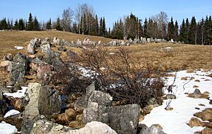
| Paikanselkä memorial area | Paikanselkä | This place marks where the front line was on March 13, 1940, when the Winter War ended. It's also where a Swedish volunteer leader, Magnus Dyrssen, was killed in 1940. | |
| Salpa Line | A defense line built along Finland's eastern border to protect the country. |
See also
 In Spanish: Salla (Finlandia) para niños
 | Isaac Myers |
 | D. Hamilton Jackson |
 | A. Philip Randolph |


