
San Andrés (island) facts for kids
|
Native name:
Islander Creole English: San Andrés
|
|
|---|---|

Top to bottom, left to right: A typical San Andrés house, San Andrés Skyline, Johnny Cay, Spratt Bight Beach, First Baptist Church and the Sunrise Hotel
|
|
 |
|

San Andrés
Location in Isla de San Andrés (Colombia)

San Andrés
Location in Colombia

San Andrés
Location in Caribbean
|
|
| Geography | |
| Coordinates | 12°35′N 81°42′W / 12.583°N 81.700°W |
| Major islands | San Andrés, Providence and Saint Catherine |
| Area | 26 km2 (10 sq mi) |
| Highest elevation | 84 m (276 ft) |
| Administration | |
|
|
|
| Department | San Andrés, Providencia and Santa Catalina |
| Demographics | |
| Population | 67,912 (2007 estimate) |
| Languages | San Andrés Creole, English, Spanish, |
| Ethnic groups | Raizal |

San Andrés (Islander Creole English: San Andrés) is a beautiful coral island in the Caribbean Sea. It is part of Colombia, but it has historical ties to the United Kingdom. San Andrés, along with the nearby islands of Providencia and Santa Catalina, forms a special department of Colombia. San Andrés is the biggest island in this group. The main languages spoken here are Spanish, English, and San Andrés–Providencia Creole.
San Andrés is about 50 kilometers (31 miles) south of Providencia. The whole group of islands is about 750 kilometers (466 miles) north of mainland Colombia. The total area of the islands, including small cays and reefs, is about 57 square kilometers (22 square miles). The islands themselves cover about 45 square kilometers (17 square miles). In 2000, the area was named a UNESCO Biosphere Reserve. It is called the "Seaflower Biosphere Reserve." This reserve includes the islands and a huge part of the Caribbean Sea, about 300,000 square kilometers (115,831 square miles). This special status helps protect the amazing plants and animals found here.
The main town and capital of the department is on the northern tip of the island. It is also called San Andrés, but people often call it El Centro. A 30-kilometer (19-mile) road goes around the island. Along this road, you can find lovely beaches, coral reefs, small islands (cays), and even blowholes. Other interesting places include La Loma, the Baptist Church, and a large pond called La Laguna. The island has many coconut palm trees and lush green areas. All these features make San Andrés a popular holiday spot.
Contents
Island History
Early Explorers and Settlers
The history of San Andrés and Providencia includes many stories about pirates. The island first appeared on Spanish maps in 1527. It is believed that Christopher Columbus might have seen these islands during his fourth trip. The Dutch arrived in the late 1500s, and English settlers came in 1628.
English Control and Pirates

English Puritans were among the first to settle here. They came from Barbados and England between 1627 and 1629. They liked the good climate and fertile land. In 1631, the Puritans made the Dutch settlers leave. Some settlers also came from Wales. Many colonists first came to San Andrés. Later, some moved to Providencia Island. This island had fresh water and was safer from invaders.
From 1633, enslaved people were brought from Jamaica. They worked in logging and grew crops like cotton and tobacco. In 1635, the Spanish tried to take over the islands. They saw how important the islands were for trade. However, the Spanish were soon forced to leave. Famous privateers, like Welsh privateer Sir Henry Morgan, also used the island. In 1670, Morgan used San Andrés as a base. He attacked Spanish ships carrying gold in the Caribbean. He also attacked Panama and Santa Maria. People still believe that Morgan's hidden treasure is in an underwater cave nearby.

Changes in Control
After the Spanish invasion failed, England controlled the islands until 1787. Then, England agreed to give control back to Spain. In 1792, Spain officially recognized the islands as theirs. The Catholic religion became common, and a church was built. San Andrés also became a place where people did not have to pay import or export taxes.
Becoming Part of Colombia
In 1802, the people of the islands asked to be part of the Viceroyalty of New Granada. This was a Spanish colony that included much of modern-day Colombia. They did not want to be part of Guatemala. In 1803, San Andrés officially became part of New Granada for political and economic reasons.
In 1810, parts of New Granada declared independence from Spain. Local councils were set up in San Andrés and Providencia. The government gave land titles to families on the islands. This made sure people owned their land. In 1818, independent forces led by Simón Bolívar took over the islands. San Andrés became part of Gran Colombia in 1822.

In 1821, the Constitution of Cúcuta was created. It stated that every child born in Colombia was born free. This meant that slavery would eventually end in San Andrés. In 1848, San Andrés was declared a free port. This meant goods could be traded without many taxes. In 1851, slavery was officially ended in Colombia. This led to more people learning to read and write.
20th Century Events
In 1900, France decided that all the islands belonged to Colombia. In 1902, two people sent by U.S. President Theodore Roosevelt visited San Andrés. They asked the islands to join Panama. But the islanders said no. They wanted to stay with Colombia. In 1903, Panama became an independent country. The islanders again refused to join the United States or Panama.
In 1912, the Municipality of San Andres and Providencia was created. This gave the islands more control over their own government. In 1928, a treaty was signed with Nicaragua. In this treaty, Nicaragua recognized that the islands belonged to Colombia. In 1943, Colombia joined World War II. This happened after a German submarine sank one of their boats near San Andrés. In 1953, San Andrés was again made a free port. In 1991, the islands became a department of Colombia. In 2000, the islands became a UNESCO World Biosphere Reserve.
Modern Times
In 2001, Nicaragua said the 1928 treaty was not valid. They claimed it was signed under pressure. Nicaragua then took its claim to the International Court of Justice (ICJ). They wanted control over the waters east of the islands. In 2007, the ICJ said that Colombia fully owned the islands of San Andrés, Providencia, and Saint Catherine. However, they left open the question of the exact sea border with Nicaragua.
Island Geography

San Andrés is the largest island in its department. It is located in the Caribbean Sea. The island is about 13 kilometers (8 miles) long and 3 kilometers (2 miles) wide. It covers about 26 square kilometers (10 square miles). Providencia, the next largest island, is about 80 kilometers (50 miles) to the northeast. San Andrés is mostly flat. Its highest point is about 55 meters (180 feet) above sea level.
A small mountain range runs from south to north across San Andrés. Its highest point is called Cerro La Loma. The island's soil suggests it was formed by a volcano. This volcano brought older rocks to the surface. The soil is mostly red clay and is quite fertile. You can find small quartz deposits, especially near La Loma Cove. Most of the island is covered in grass, trees, and other plants. The coastline has sand instead of rocks. The middle of the island has a chain of hills. The island has only small, temporary streams. There are no major rivers.
On the southwest coast, you can find features like Bobby Rock and Fisher Rock. Rock Point is on the southeastern coast. Suky Bay is in the central western part of the island. The northern part of the island has a beach. However, the western part of the island does not have beaches.

A small coral reef surrounds the northwest side of the island. There are also several small islands (keys) nearby. These keys are home to many different animals and plants. Tourists love to visit them. Johnny Cay is a small coral island about 1.5 kilometers (0.9 miles) north of San Andrés Town. It has beautiful white-sand beaches and coconut trees. Swimming here can be risky due to strong currents. A natural park was created here in 2001. Haynes Cay is where cruise ships dock. It has large coral farms with many types of coral. It is also a great place for snorkeling and diving. You can see colorful fish here. El Acuario (The Aquarium) Cay is next to Haynes Cay. It is popular for snorkeling because the water is shallow and calm.
Island Climate
San Andrés has a tropical climate. This means it is warm all year round. Average temperatures are between 24°C (75°F) and 30°C (86°F). The island has two main seasons: a dry season and a rainy season. The rainy season lasts from May to January. During this time, the humidity is high. Trade winds blow from the north starting in late October. From November to mid-January, the wind usually comes from the east. Sometimes there are storms in the northeastern Caribbean.
People of San Andrés
The island's population is about 75,000 people. In 2007, it was 72,912. In 1973, it was only 20,000. Many people have moved to the island from mainland Colombia. They now make up about two-thirds of the population. The original islanders are descendants of African and European settlers. They were the first to live on the islands.
Island Economy
The island's economy used to rely on fishing and small farms. But things changed when air travel from Colombia started. In 1954, the island was declared a duty-free zone. This meant people did not have to pay taxes on many goods. This brought many tourists and new residents from the mainland. Many people from Lebanon also moved to the island. They still play a big role in the local economy today. In the 1990s, the local government set rules to control how many people could move to the island. This was to help protect the local culture. There are no large factories or industries on the island.
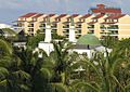
Tourism on San Andrés
Tourism has grown a lot on San Andrés. From 2003 to 2006, the number of tourists increased by more than 10 percent. In 2006, over 377,000 tourists visited the island. Most of them were from other countries. In July 2011, the island welcomed 23,000 more tourists than the year before. The island has also invested a lot of money in new hotels.
Popular Tourist Spots
Here are some of the popular places to visit on the island:

- North End: This area is also called El Centro. It is the main hub for hotels, shops, banks, and government offices.
- Islander House Museum: This museum was created by local people. It helps visitors learn about the island's culture and traditions.
- La Loma: This town is mostly home to native islanders. It is a great place to see traditional island houses.
- Cayo Santander (or Coton Cay): This small island is across from the main pier. English settlers used to grow cotton and coconuts here.
- The Cliff or Peñon: This is a rocky cliff about 30 meters (98 feet) high. It is near the airport.
- Cocoplumbay: This beautiful beach is in the town of Saint Louis. It has white sand and clear blue-green water. It is a favorite spot for tourists.
- La Piscinita: This is a natural pool formed by the sea in the coral rock.
- Rocky Cay Beach: Located on the north side of the island, it is a popular beach.
Plants and Animals

The island has many different plants. It has large mangrove swamps. The biggest one is the Old Mangrove Point Regional Park. There are 12 mangrove forests with red, black, and white mangroves. These areas are full of many plant and animal species. They help keep the ecosystem healthy. You can also find coconut palm trees, breadfruit trees, and tall native trees. The island also has green pastures and farmlands.
.jpg)
One special bird found here is the San Andres vireo (Vireo caribaeus). It is also found on Providencia and St. Catherine Islands. This small, green bird lives in mangrove and scrub areas. It is about 5 inches (13 cm) long and weighs about 16–20 grams (0.56–0.71 oz). It eats insects and fruits. Sadly, this bird is critically endangered. Its home has been shrinking because the capital city has grown a lot. Its habitat is now only about 18 square kilometers (7 square miles) in the southern part of the island. To protect this bird, people have suggested making the mangrove swamps a protected area. Another common bird on the island is the white-winged dove (Zenaida asiatica).
Several unique bird types live only on this island. These include:
- Green-breasted mango Anthracothorax prevostii hendersoni
- Black-whiskered vireo Vireo altiloquus canescens
- Tropical mockingbird Mimus gilvus magnirostris
- Yellow warbler (Golden) Setophaga petechia flavida
- Bananaquit Coereba flaveola oblita
- Black-faced grassquit Tiaris bicolor grandior
In the water, you can find oysters and crabs. The coral reefs around the island have many types of coral. These include staghorn coral, Elkhorn coral, pillar coral, brain coral, and finger coral.
The only wild mammal found on San Andrés is the Jamaican fruit bat (Artibeus jamaicensis).
Island Settlements

The people on the island live in a few main areas. San Andrés, also called El Centro, is the biggest town. It is the main center for business and tourism. It is located at the northern end of the island and is the capital. The government offices, shops, banks, hotels, and the airport are all in this area.

La Loma is a smaller village in the center of the island. It is mostly home to the native islanders. It is famous for its Baptist Church, built in 1847. This church was rebuilt using pine wood from Alabama. The church is on a central road and used to be a guide for ships. From the top of the hill in La Loma, you can see beautiful views of the "seven coloured sea" (the Caribbean Sea).
On the eastern coast is Saint Louis. This is a small tourist town. It has a beautiful stretch of white-sand beach. Traditional wooden houses are also found along the beach. The sea here is usually calm, making it great for snorkeling. This area used to be a port for exporting coconuts.
Island Culture
Spanish is the main language spoken today. However, until the 1970s, English, traditional architecture, and religion were a big part of the island's culture. The local people spoke Creole. This was called the Raizal culture of the Afro-Caribbean group. Now, the island's culture is a mix of Latin American and English-Caribbean styles. Other groups, like Chinese and Middle Eastern people, also live on the island.

San Andrés is also known for its local music. This includes calypso, soca, reggae, and church music. Concerts are held every May at the Old Coliseum during the "Green Festival." Other events include independence day celebrations on July 20. The "Coconut Reign" (Reinado del Coco) festival is held in November.
Religion on the Island
Most islanders are Protestant, with Baptists being the largest group. Other religious groups are also present. These include Seventh-day Adventists, Roman Catholics, Muslims, and Jews.
Things to Do and See
San Andrés Island attracts many visitors. There are many interesting places to see. Some important ones are: La Loma with its Baptist Church, a small blowhole at Hoyo Soplador, and the snorkeling spot at La Piscinita. You can also visit the white beaches of Saint Louis and the coral island of Johnny Cay. Other spots include the Pond, Haynes Cay, Morgan's Cave, and West View. The small cay in San Andrés Bay is the most visited place. El Cove ("the cove") has the deepest place for boats to anchor.

Diving is a very popular water sport here. The water depth ranges from 3 to 30 meters (10 to 98 feet). The water is very clear, with visibility from 10 to 30 meters (33 to 98 feet). These are great conditions for diving. You can see three types of underwater formations: walls of seaweed and small coral reefs, large groups of different corals, and underwater flat areas with lots of marine life. Many places offer diving lessons.
La Piscinita, on the western side of the island, has calm waters. This makes it perfect for snorkeling. You can see many fish here. Hoyo Soplador is at the southern end of the island. It is a blowhole where water shoots up to 20 meters (66 feet) high. This happens when the tide and wind are just right. It is also where an International Surf Competition is held once a year.
The Pond, also called La Laguna ("Big Pond"), is on top of a hill. It is 400 meters (1,312 feet) long and 250 meters (820 feet) wide. It gets its fresh water from rainfall and is 30 meters (98 feet) deep. It has many different plants and animals, like white herons, pigeons, palm trees, and fruit trees. A small alligator species can also be seen here.
Morgan's Cave is named after the privateer Henry Morgan. People say he hid his treasures here. You can reach the cave through an underwater passage. There is also a museum here. A seawater aquarium shows Caribbean marine life. West View is a great place for snorkeling, swimming, and diving. The water here is 3 to 10 meters (10 to 33 feet) deep.
Sports on the Island
Horse racing is a weekly event on Saturdays, even if only two horses race. Cockfighting is also very popular on the island. It is seen as a traditional sport.
There are three small stadiums in the town center. Each one is for a different sport: softball, football (soccer), and baseball. Islanders play these sports widely, especially in the southern part of the island. Football teams also play in the Copa Claro competition.
Getting Around San Andrés
The airport in the northern part of the island has helped the island's economy grow. Especially in San Andrés town. Gustavo Rojas Pinilla International Airport has flights from airlines like American Airlines and Avianca. You can fly to cities like Barranquilla, Bogotá, and Miami. There are also charter flights from Montréal during winter.
You can also visit the island by cruise ship. This journey usually takes 3–4 days. There are no regular passenger ships to the island. However, some cargo ships might carry a few passengers. The island has a good network of paved roads. These connect to the main circular road, which is 30 kilometers (19 miles) long. A tourist train also operates on the island. Boat services are available to visit different towns and tourist spots along the coast.
See also
 In Spanish: Isla de San Andrés (Colombia) para niños
Images for kids
-
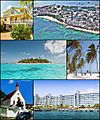
Top to bottom, left to right: A typical San Andrés house, San Andrés Skyline, Johnny Cay, Spratt Bight Beach, First Baptist Church and the Sunrise Hotel
-
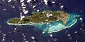
Satellite image of San Andrés Island
-
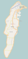
Map of the island
-

Pirate Henry Morgan
-
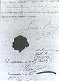
The Constitution of Cúcuta was an important document.
-
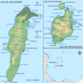
Map of San Andrés and Providencia
-
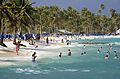
Beach in San Andrés
-
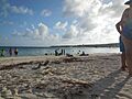
Rocky Cay Beach
-
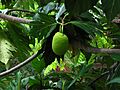
Breadfruit tree
-
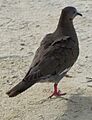
White-winged dove (Zenaida asiatica) on San Andrés.
-

Typical house in San Andrés Island.
-

Iglesia Bautista Emmanuel, built in La Loma in 1847.
-
Mosque.
-
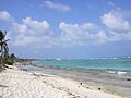
San Andrés beach.
