
San Lorenzo, Morovis, Puerto Rico facts for kids
Quick facts for kids
San Lorenzo
|
|
|---|---|
|
Barrio
|
|

Puente La Esperanza (The Hope Bridge) over Morovis River in San Lorenzo
|
|

Location of San Lorenzo within the municipality of Morovis shown in red
|
|

San Lorenzo, Morovis, Puerto Rico
Location in Caribbean
|
|
| Commonwealth | |
| Municipality | |
| Area | |
| • Total | 3.14 sq mi (8.1 km2) |
| • Land | 3.09 sq mi (8.0 km2) |
| • Water | 0.05 sq mi (0.1 km2) |
| Elevation | 239 ft (73 m) |
| Population
(2010)
|
|
| • Total | 1,209 |
| • Density | 391.3/sq mi (151.1/km2) |
| Source: 2010 Census | |
| Time zone | UTC−4 (AST) |
| Zip code |
00687
|
San Lorenzo is a special area called a barrio in the town of Morovis, Puerto Rico. A barrio is like a neighborhood or a district. San Lorenzo has six smaller parts called sectors. In 2010, about 1,209 people lived there.
Contents
History of San Lorenzo
Early Days and Population
Puerto Rico became a territory of the United States after the Spanish–American War. This happened because of a peace agreement called the Treaty of Paris of 1898. In 1899, the U.S. government counted everyone living in Puerto Rico. They found that 884 people lived in San Lorenzo barrio back then. By 2010, the population had grown to 1,209 people.
Car Races and Safety
For many years, secret car races happened in San Lorenzo. These races were very popular. Thousands of people, sometimes up to 6,000, would come to watch. But on July 18, 1998, there was a serious accident. After this, the races were stopped to keep everyone safe.
Hurricane Maria's Impact
On September 20, 2017, Hurricane Maria hit Puerto Rico very hard. San Lorenzo was one of the areas that suffered a lot. The hurricane washed away bridges and caused power outages that lasted for many months.
The main bridge connecting San Lorenzo to the PR-567 highway was destroyed. This left the community cut off. There was an old road that went right through the river, but it was often too dangerous to use. Sometimes, it was passable, and people, including school buses, had to use it.
It could take an hour to drive around to find another way out of San Lorenzo. People really needed a new bridge.
The Hope Bridge
A new temporary bridge for the community was finished in April 2018. In 2019, this important bridge was officially named La Esperanza. This means "The Hope" in English. It was a symbol of new beginnings for the people of San Lorenzo.
Geography of San Lorenzo
San Lorenzo barrio is located in a central part of Morovis. It is south of Torrecillas. To its west are Morovis Sur and Río Grande. To the north, you will find Pasto and Vaga barrios. The western edge of San Lorenzo touches the town of Ciales.
Sectors of San Lorenzo
Barrios like San Lorenzo are divided into smaller areas. These smaller areas are called sectores (sectors). There are different types of sectors. Some are just called "sector," while others might be called "urbanización" or "reparto."
Here are the sectors you can find in San Lorenzo barrio:
- Parcelas San Lorenzo
- Sector Berio
- Sector El Rayo
- Sector El Salto
- Sector La Prá
- Sector Marrero
Images for kids
-
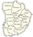
This map shows all the barrios in Morovis.
-
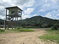
This is the racetrack in San Lorenzo where the car races used to happen.
-
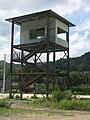
An old tower at the racetrack in San Lorenzo.
-
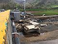
This shows a bridge that was damaged by Hurricane Maria in 2017.


See also
 In Spanish: San Lorenzo (Morovis) para niños
- List of communities in Puerto Rico
