
San Luis Pass (Galveston Island) facts for kids
Quick facts for kids San Luis Pass |
|
|---|---|

San Luis Pass Coast Chart, ca. 1853
|
|

San Luis Pass
Location in Texas

San Luis Pass
Location in the United States
|
|
| Location | |
| Coordinates | 29°04′57″N 95°07′18″W / 29.0824652°N 95.1215959°W |
| Part of | West Bay |
| Offshore water bodies | Gulf of Mexico |
| Length | 2.25 mi (3.62 km) |
| Width | .75 mi (1.21 km) |
| Depth | 10 ft (3.0 m) ~ 40 ft (12 m) |
| Drop | 40 ft (12 m) |
| Geology | Inlet |
| Topo map | AOL. San Luis Pass, TX [map]. |
| GNIS feature ID |
|
| Road Navigation | Farm to Market Road 3005 |
San Luis Pass is a narrow channel of water located at the southwest end of Galveston Island in Texas. It connects the calm waters of West Bay to the wide-open Gulf of Mexico. This pass is known for its strong water currents and changing tides. Because of these powerful currents, swimming in the pass can be very dangerous. A bridge called the San Luis Pass-Vacek Toll Bridge crosses the pass, connecting Galveston County to Brazoria County.
Contents
About San Luis Pass
The water levels in San Luis Pass can change by almost 2 feet. The currents here are very strong, even up to a mile away from the pass along the nearby islands. The depth of the pass also varies, reaching up to 40 feet deep in some places.
The shape of the pass changes often. Daily tides cause small changes, but big storms like hurricanes can drastically reshape the land and water around the pass.
Fun Activities at San Luis Pass
San Luis Pass is a popular spot for fishing. Many people enjoy fishing from the banks, especially for redfish, which are common from June to October.
While swimming is not allowed at San Luis Beach due to safety concerns, there are still ways to enjoy the area. Overnight camping is not permitted on the Galveston side of the pass. However, the San Luis Pass Camp Ground and county park on the Brazoria County side offers a place for camping.
The Galveston side of San Luis Pass is also a great place for bird watching. You might see many different kinds of birds that live near the coast.
Hurricane Ike in 2008 greatly changed the area. What used to be a public beach and driveway is now covered by the Gulf of Mexico. The land where a fishing pier's bait house once stood is now permanently underwater.
San Luis Pass-Vacek Toll Bridge
The San Luis Pass-Vacek Toll Bridge, often called the San Luis Pass Bridge, was built just before 1970. It is managed by Galveston County. This bridge has two lanes and is about 1.3 miles long. There is a small fee to cross it. The closest town on the other side of Galveston, in Brazoria County, is Surfside Beach. As of 2018, this bridge only accepts cash payments for the toll.

History of San Luis Pass
In 1878, a special station was built near San Luis Pass to help save lives at sea. This was part of the United States Life Saving Service. Station San Luis helped people along the coast of Galveston Island for 70 years.
However, a powerful hurricane in 1949 severely damaged the station. Because of this damage, the U.S. Life-Saving Service stopped its water rescue operations there by 1950.
The Island of San Luis
Across the pass from Galveston, there was once an island named San Luis. This island became connected to Follet's Island in 1885 when a smaller channel, Little Pass, closed up. Follet's Island was once known as the Velasco Peninsula.
The area of San Luis, Texas, used to be a busy settlement with about 2,000 people after 1836. By 1989, only about 20 people lived there. Today, the San Luis Pass County Park is located in this historic area.
Images for kids
-
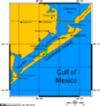
San Luis Pass connects the Gulf of Mexico and West Bay.
-
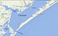
A map showing Galveston Island and San Luis Pass.


See also
 In Spanish: Paso de San Luis para niños
