
Saugeen and Cape Croker Fishing Islands 1 facts for kids
Quick facts for kids
Saugeen and Cape Croker Fishing Islands 1
|
|
|---|---|
| Saugeen & Cape Croker Fishing Isl. Indian Reserve No. 1 | |

Saugeen and Cape Croker Fishing Islands 1
Location in Southern Ontario
|
|
| Country | |
| Province | |
| County | Bruce |
| First Nations | Chippewas of Nawash and Saugeen |
| Area | |
| • Land | 10.1 ha (25.0 acre) |
The Saugeen and Cape Croker Fishing Islands 1 are a group of 89 islands in Lake Huron. These islands are part of a First Nations reserve. They are located off the western coast of the Bruce Peninsula in Ontario, Canada.
The islands stretch about 11 miles (18 km) north from Chief's Point 28 to Pike Bay. They are shared by two important First Nations groups: the Chippewas of Nawash Unceded First Nation and the Saugeen First Nation.
Contents
History of the Fishing Islands
The islands have a long and important history for fishing. People have been fishing on the Bruce Peninsula for a very long time, even as far back as 1000 BC. This was during a period called the Archaic period.
Early Fishing Practices
Later, during the Late Woodland period, both Algonquian and Iroquoian groups fished in this area. When Europeans first arrived, the Petun and Ottawa peoples were known to be fishing here.
These groups were later moved out by the Iroquois during wars in the late 1600s. However, after 1701, Algonquian peoples, especially the Chippewa, returned and reclaimed the area.
European Contact and Trade
Written records of Native fishing activities in the area began in 1788. The Hudson's Bay Company also kept records of fishing and started trading in 1818 near the Saugeen River.
When the Chippewas signed the Saugeen Surrenders in 1854, they gave up land on the Bruce Peninsula. However, they made sure to keep ownership of the islands around it. This was important so they could continue their fishing traditions.
Fish were plentiful in channels like Smokehouse Channel, Indian Channel, and the Gut. The fish were often smoked on Smokehouse Island to preserve them.
European Fishing Methods
European settlers also began to fish in the area. Alexander Macgregor was one of the first, starting in 1831. He set up his main base on Main Station Island.
He mostly used a fishing method called Seine fishing. Later, other methods like gillnet and pound net fishing were also used.
In 1834, a company called the Niagara Fishing Company took over the fishing rights. They later sold their rights to local fishermen in Southampton in 1848.
Returning the Islands
In October 1885, these islands were given up under Treaties 222 and 223. The treaties described all the islands owned by the Band in Lake Huron and Georgian Bay. This included the Saugeen Fishing Islands and Cape Hurd Islands.
Some larger islands like Barrier, Griffith, and Hay Islands were not part of this agreement.
The islands were described as having a shallow bank that stretched out up to 1.5 miles (2.4 km) from shore. Beyond this bank, the water became much deeper.
In 1968, 89 of the smaller islands were returned to Chippewa control. These islands cover an area of 10.1 hectares (25 acres).
Images for kids
-
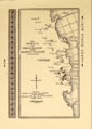
Saugeen Fishing Islands, as shown on a map from 1900

