Schofield, Wisconsin facts for kids
Quick facts for kids
Schofield, Wisconsin
|
|
|---|---|

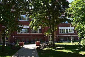
Former Schofield School in Schofield
|
|

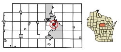
Location of Schofield in Marathon County, Wisconsin.
|
|
| Country | |
| State | |
| County | Marathon |
| Area | |
| • Total | 2.99 sq mi (7.74 km2) |
| • Land | 2.12 sq mi (5.48 km2) |
| • Water | 0.87 sq mi (2.26 km2) |
| Elevation | 1,201 ft (366 m) |
| Population
(2020)
|
|
| • Total | 2,157 |
| • Density | 1,024.11/sq mi (395.35/km2) |
| Time zone | UTC-6 (Central (CST)) |
| • Summer (DST) | UTC-5 (CDT) |
| Area code(s) | 715 & 534 |
| FIPS code | 55-72150 |
| GNIS feature ID | 1573796 |
Schofield is a city located in Marathon County, Wisconsin, in the United States. It is part of the larger Wausau, Wisconsin area. In 2020, about 2,157 people lived there.
The city got its name from William Scholfield. He arrived in the area in 1851 to open a sawmill. Over time, the city's name changed slightly, dropping the "L" from "Scholfield."
Contents
Geography of Schofield
Schofield is located right next to Lake Wausau. This lake is a part of the Wisconsin River. The city also includes the Eau Claire Flowage and the Eau Claire River. This river flows into Lake Wausau.
Schofield is south of the city of Wausau. The Wausau Downtown Airport generally separates the two cities. Schofield is a close neighbor to Wausau. It shares borders with Rothschild, Weston, and the Town of Weston. Lake Wausau and Wausau form its western and northern edges.
The United States Census Bureau says that Schofield covers about 2.83 square miles (7.33 square kilometers). Of this area, 1.76 square miles (4.56 square kilometers) is land. The remaining 1.07 square miles (2.77 square kilometers) is water.
Population and People
| Historical population | |||
|---|---|---|---|
| Census | Pop. | %± | |
| 1910 | 889 | — | |
| 1920 | 1,049 | 18.0% | |
| 1930 | 1,287 | 22.7% | |
| 1940 | 1,536 | 19.3% | |
| 1950 | 1,948 | 26.8% | |
| 1960 | 3,038 | 56.0% | |
| 1970 | 2,577 | −15.2% | |
| 1980 | 2,226 | −13.6% | |
| 1990 | 2,415 | 8.5% | |
| 2000 | 2,117 | −12.3% | |
| 2010 | 2,169 | 2.5% | |
| 2020 | 2,157 | −0.6% | |
| U.S. Decennial Census | |||
How Many People Live Here?
In 2010, a census counted 2,169 people living in Schofield. There were 994 households and 549 families. The city had about 1,232 people per square mile (475 per square kilometer). There were 1,099 homes, with about 624 homes per square mile (241 per square kilometer).
Most residents, 90.1%, were White. Other groups included 1.2% African American, 0.8% Native American, and 5.5% Asian. About 1.8% of the population was Hispanic or Latino.
Households and Families
About 25.3% of households had children under 18 living with them. Around 38.3% were married couples. Some households, 10.8%, had a female head without a husband. About 6.1% had a male head without a wife. Nearly 44.8% of households were not families.
Many households, 36.6%, were made up of single individuals. About 12.5% had someone aged 65 or older living alone. The average household had 2.18 people. The average family had 2.84 people.
The average age in the city was 39.1 years. About 21.8% of residents were under 18. People aged 18 to 24 made up 8.8%. Those 25 to 44 were 28%. Residents 45 to 64 were 26.5%. Finally, 14.8% were 65 years or older. The population was 51.7% male and 48.3% female.
Getting Around: Transportation
Airport Services
The Central Wisconsin Airport (KCWA) serves Schofield and nearby communities. This airport offers both regular commercial flights and services for smaller private planes.
See also
 In Spanish: Schofield (Wisconsin) para niños
 | Leon Lynch |
 | Milton P. Webster |
 | Ferdinand Smith |

