
Schofield Barracks facts for kids
Quick facts for kids Schofield Barracks |
|
|---|---|
| eponyms: LTG John Schofield | |
| Oahu, Hawaii, USA | |

A U.S. soldier fires an M16A2 rifle at Schofield Barracks in December 2003
|
|

Schofield Barracks

Schofield Barracks
|
|
| Coordinates | 21°29′52″N 158°3′48″W / 21.49778°N 158.06333°W |
| Type | Army post |
| Site information | |
| Controlled by | |
| Site history | |
| Built | 1908 |
| In use | 1908–Present |
| Garrison information | |
| Garrison | 25th Infantry Division |
Schofield Barracks is a large United States Army base located on the island of Oʻahu in Hawaiʻi. It's also a "census-designated place" (CDP), which means it's an area the government counts as a town for statistics. The base is next to the town of Wahiawā, separated by Lake Wilson.
The base is named after Lieutenant General John McAllister Schofield. He was a top general for the U.S. Army from 1888 to 1895. General Schofield visited Hawaiʻi in 1872. He suggested building a naval base at Pearl Harbor, which is now very famous.
Schofield Barracks covers a huge area of about 17,725 acres (71.73 km2) in the middle of Oʻahu. It was built in 1908 to help protect Pearl Harbor and the whole island. Since 1941, it has been the home of the 25th Infantry Division. This division is known as "Tropic Lightning." It also serves as the main office for the United States Army Hawaii (USARHAW).
The base is also home to the Pacific office of the Army CID, which is the Army's criminal investigation department. In 2020, about 14,904 people lived at Schofield Barracks.
Contents
Where is Schofield Barracks?
Schofield Barracks is located at 21°29′52″N 158°3′48″W. The main entrances, called Foote and Lyman gates, are on Kunia Road. If you go north from the base on Wilikina Road, you can reach Waialua and Haleʻiwa. Going east on Wilikina leads to Interstate H-2 and the towns of Wahiawā and Mililani Town. South on Kunia Road takes you past Wheeler and towards Waipahu.
The base covers about 2.8 square miles (7.18 km2) of land.
What's Inside Schofield Barracks?

Main Post Area
The Main Post is the central part of the base. It has many barracks buildings arranged around courtyards. These buildings are often called "quads" (like B Quad or C Quad). The oldest ones were built in the 1910s.
Here you'll find the main store (PX), the grocery store (Commissary), the library, and a bowling alley. There are also newer apartment-style barracks built since 1998. Important buildings like the Nehelani Club and Conroy Bowl are also in this area.
Housing for Families
Many homes on the base have been updated or rebuilt. A company called Island Palms, part of Lend Lease, manages the housing. The homes for enlisted soldiers are west of the Main Post. Homes for officers are to the north along Wilikina Drive. It usually takes a few months to get a home on base.
Training Areas
Schofield Barracks has large areas for military training.
Area X Training Ground
Area X is a big training space. Soldiers can practice air assault operations here, where helicopters land and take off. There are also covered concrete pads for shelter during training. This area includes the office that controls the firing ranges. Many different types of firing ranges are located here.
East Range Training Area
This area is east of the Main Post. It includes the Air Assault School and a course for land navigation. Soldiers often train here for the Expert Infantryman Badge (EIB). This badge shows that a soldier has special skills.
Kolekole Pass
Kolekole Road goes through the housing and training areas. It leads up to a mountain pass called Kolekole Pass. This pass connects Schofield Barracks to the Lualualei Naval Magazine. Soldiers also use this road for physical training runs.
A large steel cross was once at Kolekole Pass. It was built in 1962 but was removed in 1997. This happened after a lawsuit said it went against the idea of separating government and religion.
Schools at Schofield Barracks
The Hawaii Department of Education runs two schools on the base. These are Samuel K. Solomon Elementary School and Daniel K. Inouye Elementary School. Solomon Elementary is named after a member of the Wolfhounds, a famous military unit. Its current building opened in 2019. Daniel K. Inouye Elementary opened in 1959 as Hale Kula Elementary.
Some students living on base also go to Wheeler Elementary School. For middle and high school, students usually attend Wheeler Middle School and Leilehua High School.
The Sergeant Rodney J. T. Yano Library is also on the base. It is run by the United States Army's Family and MWR Programs. There are also public libraries nearby for everyone in the community.
25th Infantry Division Memorial
![]() The 25th Infantry Division Memorial honors the soldiers of this division. It has four statues. Each statue represents soldiers who served in different wars. These include World War II, the Korean War, the Vietnam War, and the War on Terrorism (Afghanistan and Iraq). The first statue was revealed in June 2005.
The 25th Infantry Division Memorial honors the soldiers of this division. It has four statues. Each statue represents soldiers who served in different wars. These include World War II, the Korean War, the Vietnam War, and the War on Terrorism (Afghanistan and Iraq). The first statue was revealed in June 2005.
Climate
Schofield Barracks has a tropical savanna climate. This means it's warm all year round. Because it's at a higher elevation, it's a little cooler than Honolulu. The weather is still very tropical. It gets more rain in the winter months, similar to some places in California.
| Climate data for Schofield Barracks | |||||||||||||
|---|---|---|---|---|---|---|---|---|---|---|---|---|---|
| Month | Jan | Feb | Mar | Apr | May | Jun | Jul | Aug | Sep | Oct | Nov | Dec | Year |
| Mean daily maximum °F (°C) | 78.2 (25.7) |
78.1 (25.6) |
79.1 (26.2) |
79.5 (26.4) |
82.4 (28.0) |
85.3 (29.6) |
86.6 (30.3) |
87.1 (30.6) |
87.0 (30.6) |
84.7 (29.3) |
81.5 (27.5) |
78.5 (25.8) |
82.4 (28.0) |
| Daily mean °F (°C) | 70.6 (21.4) |
69.9 (21.1) |
71.5 (21.9) |
72.0 (22.2) |
74.2 (23.4) |
76.5 (24.7) |
77.8 (25.4) |
78.2 (25.7) |
78.1 (25.6) |
76.7 (24.8) |
74.3 (23.5) |
71.3 (21.8) |
74.3 (23.5) |
| Mean daily minimum °F (°C) | 62.9 (17.2) |
61.7 (16.5) |
63.8 (17.7) |
64.4 (18.0) |
66.0 (18.9) |
67.7 (19.8) |
69.0 (20.6) |
69.3 (20.7) |
69.2 (20.7) |
68.7 (20.4) |
67.0 (19.4) |
64.1 (17.8) |
66.2 (19.0) |
| Average precipitation inches (mm) | 7.1 (180) |
5 (130) |
5 (130) |
3.5 (89) |
1.9 (48) |
1 (25) |
1.3 (33) |
1.4 (36) |
1.6 (41) |
3 (76) |
4.5 (110) |
5.4 (140) |
40.7 (1,030) |
Who Lives at Schofield Barracks?
|
Schofield Barracks CDP
|
|
|---|---|

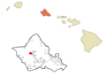
Location in Honolulu County and the state of Hawaii
|
|
|
Schofield Barracks
Location in Hawaii
|
|
| Country | |
| State | |
| Area | |
| • Total | 2.77 sq mi (7.18 km2) |
| • Land | 2.77 sq mi (7.18 km2) |
| • Water | 0.00 sq mi (0.00 km2) |
| Elevation | 900 ft (300 m) |
| Population
(2020)
|
|
| • Total | 14,904 |
| • Density | 5,378.56/sq mi (2,076.46/km2) |
| Time zone | UTC-10 (Hawaii-Aleutian) |
| ZIP code |
96857
|
| Area code(s) | 808 |
| FIPS code | 15-69050 |
| Historical population | |||
|---|---|---|---|
| Census | Pop. | %± | |
| 2020 | 14,904 | — | |
| U.S. Decennial Census | |||
In 2000, about 14,428 people lived in this area. Most households were families, with many having children under 18. The average household had about 3.55 people.
The population was quite young. About 32.1% were under 18 years old. The average age was 22 years. For every 100 females, there were about 152 males.
The median income for a family was around $32,970. A small number of families and people lived below the poverty line.
Army Units at Schofield Barracks
Several important U.S. Army units are based at Schofield Barracks:
 25th Infantry Division
 8th Military Police Brigade (Military Police help keep order)
 Army CID, Pacific field office (Army's criminal investigators)
 130th Engineer Brigade (Engineers build and maintain things)
 500th Military Intelligence Brigade (Intelligence units gather information)
 516th Signal Brigade (Signal units handle communications)
 45th Sustainment Brigade (Sustainment units provide supplies and support)
 US Army Health Clinic-Schofield Barracks (Provides medical care)
 U.S. Army Installation Management Command-Schofield Barracks (Manages the base itself)
Images for kids
-
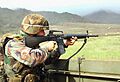
A U.S. soldier fires an M16A2 rifle at Schofield Barracks in December 2003
-
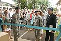
Major General Charles A. Flynn cuts the ceremonial ribbon during the opening of the SHARP Resource Center on Schofield Barracks, October 17, 2014.
-
Location in Honolulu County and the state of Hawaii
See also
 In Spanish: Schofield Barracks para niños
