Schroeppel, New York facts for kids
Quick facts for kids
Schroeppel, New York
|
|
|---|---|

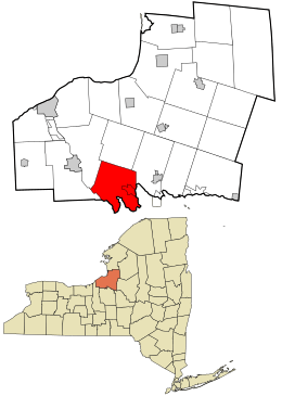
Location in Oswego County and the state of New York.
|
|
| Country | United States |
| State | New York |
| County | Oswego |
| Area | |
| • Total | 43.20 sq mi (111.88 km2) |
| • Land | 42.20 sq mi (109.30 km2) |
| • Water | 1.00 sq mi (2.58 km2) |
| Elevation | 394 ft (120 m) |
| Population
(2010)
|
|
| • Total | 8,501 |
| • Estimate
(2016)
|
8,208 |
| • Density | 194.50/sq mi (75.10/km2) |
| Time zone | UTC-5 (Eastern (EST)) |
| • Summer (DST) | UTC-4 (EDT) |
| ZIP code |
13135
|
| Area code(s) | 315 |
| FIPS code | 36-65618 |
| GNIS feature ID | 0979471 |
| Website | Town Website |
Schroeppel is a town in Oswego County, New York, United States. In 2010, about 8,501 people lived here. The town got its name from the Schroeppel family, who were among the first landowners. You can find Schroeppel in the southeastern part of Oswego County.
Contents
A Look at Schroeppel's History
Schroeppel became its own town in 1832. Before that, it was part of a town called Volney. A special building, the Schroeppel House, was added to the National Register of Historic Places in 1982. This means it's an important historical site.
Exploring Schroeppel's Geography
Schroeppel is located near some important waterways. The Oneida River forms the border on the southwest side. This river separates Schroeppel from Onondaga County. The Oswego River also helps form part of the town's southwestern edge. The famous Erie Canal runs along the southern border of Schroeppel.
The town covers a total area of about 43.2 square miles (111.88 square kilometers). Most of this area, about 42.3 square miles (109.30 square kilometers), is land. The rest, about 0.9 square miles (2.58 square kilometers), is water.
Who Lives in Schroeppel?
| Historical population | |||
|---|---|---|---|
| Census | Pop. | %± | |
| 1840 | 2,098 | — | |
| 1850 | 3,258 | 55.3% | |
| 1860 | 4,011 | 23.1% | |
| 1870 | 3,987 | −0.6% | |
| 1880 | 3,381 | −15.2% | |
| 1890 | 3,026 | −10.5% | |
| 1900 | 3,012 | −0.5% | |
| 1910 | 2,707 | −10.1% | |
| 1920 | 2,617 | −3.3% | |
| 1930 | 3,010 | 15.0% | |
| 1940 | 3,219 | 6.9% | |
| 1950 | 4,037 | 25.4% | |
| 1960 | 5,554 | 37.6% | |
| 1970 | 7,153 | 28.8% | |
| 1980 | 8,016 | 12.1% | |
| 1990 | 8,931 | 11.4% | |
| 2000 | 8,566 | −4.1% | |
| 2010 | 8,501 | −0.8% | |
| 2016 (est.) | 8,208 | −3.4% | |
| U.S. Decennial Census | |||
In 2000, about 8,566 people lived in Schroeppel. There were 3,251 households, which are groups of people living together. About 2,347 of these were families. The population density was about 202 people per square mile.
Most people in Schroeppel, about 97.79%, were White. Other groups included African American, Native American, and Asian residents. About 0.84% of the population identified as Hispanic or Latino.
Many households, 36.9%, had children under 18 living with them. More than half, 55.6%, were married couples. About 22.6% of all households were people living alone.
The average age of people in Schroeppel was 36 years old. About 28.1% of the population was under 18. About 10.1% were 65 years old or older.
The average income for a household in the town was $39,662. For families, the average income was $45,766. About 9.7% of the total population lived below the poverty line. This included 12.4% of those under 18 and 12.4% of those 65 or older.
Communities and Places in Schroeppel
Schroeppel has several smaller communities and interesting spots:
- Bowen Corners – A small community near the northern border of the town.
- Caughdenoy – A community located on the eastern edge of the town.
- Gilbert Mills – Found in the northwestern part of town. It was named after the Gilbert brothers, who built a mill here.
- Great Bear Siding – A specific location in the southwestern area of the town.
- McMahon Corners – Another community located near the northern town line.
- Peacock Corners – A community just north of Sand Ridge.
- Pennellville – A community in the center of Schroeppel. It was named after Dr. Richard Pennell.
- Peter Scott Swamp – A swampy area located in the southern part of the town.
- Phoenix – This is the Village of Phoenix, a larger community within Schroeppel.
- Roosevelt Corners – A community near the northern border of the town.
- Sand Ridge – A community located in the southern part of the town.
- Shephard Corners – Another community found near the northern town line.
- Stewart Corners – A community located north of Peter Scott Swamp.
See also
 In Spanish: Schroeppel para niños
 | Kyle Baker |
 | Joseph Yoakum |
 | Laura Wheeler Waring |
 | Henry Ossawa Tanner |

