Seaborough Hill facts for kids
Quick facts for kids Seaborough Hill |
|
|---|---|

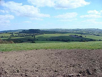
View from Seaborough Hill of farmland around the Axe river valley.
|
|
| Highest point | |
| Elevation | 204 m (669 ft) |
| Prominence | 80 m (260 ft) |
| Parent peak | Lewesdon Hill |
| Listing | Tump |
| Geography | |
| Location | Dorset and Somerset, England |
| Parent range | Yeovil Scarplands |
| OS grid | ST429071 |
| Topo map | OS Landranger 193 |
Seaborough Hill is a cool place where the counties of Dorset and Somerset meet in southwestern England. It's a tall ridge, standing at 204 meters (about 670 feet) high. This hill is part of the Yeovil Scarplands, a range of hills in the area. It's also known as a "Tump," which means it stands out quite a bit from the land around it.
Contents
Seaborough Hill: A Dorset-Somerset Landmark
Where is Seaborough Hill?
Seaborough Hill is located just north of a small village called Seaborough. It's also about 3 kilometers (less than 2 miles) southwest of the town of Crewkerne. A small road goes right over the top of the hill, running from north to south.
What Can You See on the Hill?
Near the northern end of the hill's top, close to Honeydown Farm, you'll find a trig point. This is a special marker that surveyors use to measure the land. It sits at 201 meters high. There are also some scattered woods on the sides of the hill, both to the west and east.
Rivers and Trails Nearby
The River Axe flows past the hill to the south. This river eventually reaches the sea at Lyme Bay. Two famous walking paths also go around Seaborough Hill. The Liberty Trail passes by to the north, and the Monarch's Way goes to the south. These trails are great for exploring the beautiful countryside.
County Borders
The border between Dorset and Somerset counties runs right along the top of Seaborough Hill. It then curves around the northern part of the hill before heading off to the southeast. This means you can stand on the hill and be in two different counties at once!

