Sgùrr Ghiubhsachain facts for kids
Quick facts for kids Sgùrr Ghiubhsachain |
|
|---|---|

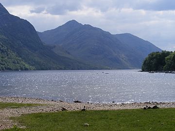
Sgùrr Ghiubhsachain and Loch Shiel from Glenfinnan
|
|
| Highest point | |
| Elevation | 849 m (2,785 ft) |
| Prominence | 614 m (2,014 ft) Ranked 106th in British Isles |
| Parent peak | Sgùrr Dhòmhnuill |
| Listing | Corbett, Marilyn |
| Naming | |
| English translation | Peak of the fir-wood |
| Language of name | Scottish Gaelic |
| Geography | |
| Location | West Lochaber, Highland, Scotland |
| Parent range | Northwest Highlands |
| OS grid | NM875752 |
| Topo map | OS Landranger 40 |
Sgùrr Ghiubhsachain is a mountain located in the Lochaber area, in the west of Scotland. Its name means "Peak of the fir-wood" in Scottish Gaelic. This mountain stands south of Glenfinnan and southeast of Loch Shiel. It might not be as tall as the famous Nevis range, but it's still a big challenge!
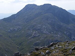
Sgùrr Ghiubhsachain is quite far from any main roads. Its sides are very steep and rocky, and there are no clear paths. Even though it's fairly easy to reach the starting point from the road between Fort William and Mallaig, you might find yourself completely alone on this mountain, even on a sunny summer day. It's a true wilderness experience!
Contents
Climbing Sgùrr Ghiubhsachain
If you want to climb Sgùrr Ghiubhsachain, the best place to start is a car park at Callop. This spot is close to the A830 road, which connects Fort William and Mallaig. From Callop, there are two main ways to reach the top: one follows the banks of Loch Shiel, and the other goes via the Allt na Cruaiche.
Loch Shiel Route
From Callop, you can follow a track that was made for forestry vehicles. It heads west, then turns southwest along the edge of Loch Shiel. If you plan to come back the same way, using a bicycle can save you a lot of time on this part of the journey!
After about 6 kilometers, this track leads to a small house called Guesachan. From here, you can start climbing the north ridge of the mountain. This ridge is steep and rocky, so you might need to do some scrambling. Scrambling means using both your hands and feet to climb over rocks. Some guides suggest avoiding the very bottom part of the ridge by going through the Allt Coire Ghiubhsachain valley.
Once you reach a smaller peak about 820 meters high, you'll follow a short ridge. This ridge goes down a little bit into a small dip (called a col) before rising up to the main summit. The very top of Sgùrr Ghiubhsachain is marked by a large pile of stones, known as a cairn.
Allt na Cruaiche Route
Another way to climb Sgùrr Ghiubhsachain from Callop is to follow a path west of the Allt na Cruaiche stream. This path eventually reaches about 400 meters high before going down into Cona Glen.
Be aware that this path isn't always in great condition. Parts of it can be very boggy, meaning it's wet and muddy. In fact, some parts were so wet they even had tadpoles living in them! Also, some of the lower path was removed to build a road for a new hydro-electric project.
From the highest point of this path, you can climb up to a col (a dip between two peaks) that is about 600 meters high. This col is northeast of Sgùrr Ghiubhsachain. From this 600m col, the path to the smaller col between the main and side peaks helps you avoid any very steep, smooth rock sections.
Sgorr Craobh a'Chaorainn
For climbers who enjoy "peak bagging" – which means trying to reach the top of many different mountains – you might want to include Sgorr Craobh a'Chaorainn in your trip. This mountain is also known as "rowantree peak" and is located northeast of the 600m col we just talked about.
Climbing over Sgorr Craobh a'Chaorainn can be a good alternative to part of the Allt na Cruaiche path. It also has some steep parts where you might need to scramble. There's a tricky step west of the summit that you can go around on the south side to make it easier.
 | Janet Taylor Pickett |
 | Synthia Saint James |
 | Howardena Pindell |
 | Faith Ringgold |


