
Loch Shiel facts for kids
Quick facts for kids Loch Shiel |
|
|---|---|

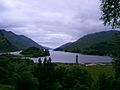
Loch Shiel and Glenfinnan monument
|
|

Loch Shiel
Location in Highland
|
|
| Location | Lochaber, Highland, Scotland |
| Coordinates | 56°47′08″N 5°35′12″W / 56.78556°N 5.58667°W |
| Type | freshwater loch |
| Primary inflows | River Finnan, Callop River, River Polloch |
| Primary outflows | River Shiel |
| Basin countries | United Kingdom |
| Max. length | 28 km (17.5 mi) |
| Surface area | 19.6 km2 (7.6 sq mi) |
| Average depth | 41 m (133 ft) |
| Max. depth | 120 m (393 ft) |
| Water volume | 0.8 km3 (0.19 cu mi) |
| Residence time | 1.37 year |
| Surface elevation | 4.6 m (15 ft) |
| Settlements | Glenfinnan, Ardshealach, Acharacle |
- See Glen Shiel for the much smaller Loch Shiel in Lochalsh.
Loch Shiel (Scottish Gaelic: Loch Seile) is a large freshwater loch in Scotland. It is located about 20 kilometres (12 mi) west of Fort William in the Highland area.
This loch is 28 kilometres (17+1⁄2 mi) long, making it the 4th longest loch in Scotland. It is also the longest loch that still has a natural river flowing out of it, without its water level being controlled by people. Loch Shiel is very deep, reaching 120 m (393 ft) in some parts.
The loch changes a lot from one end to the other. In the north-east, it is deep and surrounded by tall mountains. In the south-west, it is shallower and surrounded by bogs and open fields. The 4 km long River Shiel flows from this end into the sea at Loch Moidart, near Castle Tioram.
The hills around Loch Shiel are very beautiful. Many films have used the loch as a filming location because of its stunning views. One of the most famous views is from the Glenfinnan monument, looking south over the loch with its wooded hillsides and steep, bare mountain tops.
Loch Shiel is less than 10 metres above sea level. It was formed at the end of the last ice age. Back then, glaciers left behind large piles of rock and dirt, which blocked what used to be a sea loch.
Contents
Nature and Wildlife at Loch Shiel
| Loch Shiel National Scenic Area | |
|---|---|

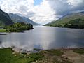
Looking north east along the loch.
|
|
| Location | Highland, Scotland |
| Area | 130 square kilometres (50 sq mi) |
| Established | 1981 |
| Governing body | NatureScot |
Loch Shiel is a very important place for nature. It is a Special Protection Area (SPA) because many black-throated divers come here to breed. The land around the loch is also an SPA because golden eagles nest there.
Birds and Fish of the Loch
Many other bird species live around the loch, including:
- White-tailed sea eagles
- Red-throated divers
- Peregrine falcons
- Eurasian sparrowhawks
- Common kestrels
- Ospreys
- Hen harriers
You can also find several types of ducks, such as little grebes, goosanders, red-breasted mergansers, mallards, goldeneyes, and tufted ducks.
The loch is home to different fish species, including salmon, sea trout, and brown trout. If you want to go fishing, you need a permit from the Lochaber Fisheries Trust. These permits are available from Acharacle, at the south-west end of the loch.
Forests and Plants
There are old Caledonian Forest areas on the islands in the loch, like Eilean Camas and Eilean Ghleann Fhoinainn. You can also find them at Meall na h-Airigh at the northern end of the loch.
Along the shoreline, there are woodlands of oak and alder trees. These are part of what is sometimes called the "Celtic rainforest." This area is a Special Area of Conservation because of its unique plants. NatureScot helps protect these woodlands, but they face challenges from too many animals eating young plants and from invasive species. Otters also live along the loch's shoreline.
Claish Moss Raised Bog
To the south of the loch is Claish Moss. This is one of the best examples of a raised bog in Britain. A raised bog is a special type of wetland that has grown upwards over thousands of years. This bog has been forming for about 8,000 years. Tiny pollen grains are preserved in the peat here, which helps scientists learn about the plants that have grown in the bog over time. Claish Moss is also a Special Area of Conservation.
Loch Shiel National Scenic Area
Loch Shiel gives its name to the Loch Shiel National Scenic Area. Scotland has 40 such areas, which are chosen for their amazing scenery. This helps to protect them from certain types of building or development. The Loch Shiel NSA covers a large area of 130 square kilometres (50 sq mi). It includes the tops of the hills on both sides of the loch, the hills around Glen Hurich, and the famous monument at Glenfinnan.
History of Loch Shiel
Loch Shiel has a rich history, playing an important role in the lives of people in the Scottish Highlands for centuries.
Ancient Sites and Burial Places
On the largest island in the loch, Eilean Fhianain, you can find the ruins of a medieval chapel. This chapel is dedicated to St. Finan. It might even be on the site of a small monastery that St. Finan built in the seventh century.
The chapel was likely built by Alan MacRuaridh, a chief of Clan Ranald. The clan used the island as a burial place until the late 1500s. People still use the island for burials today, and it is a protected Scheduled Ancient Monument.
Strategic Importance and Battles
Acharacle, at the south end of the Loch, was the site of a battle in 1140. In this battle, a leader named Somerled defeated the Norse people. This victory helped him create the powerful dynasty of the Lord of the Isles.
In ancient times, the loch was a very important way to travel through the mountains. The short River Shiel was easy to sail on, connecting the loch to the sea. However, today the river is too shallow to navigate. During the medieval period, the loch formed the border between different areas or lordships: Moidart to the west, Ardgour to the east, and Sunart in the south.
Castle Tioram, located on a tidal island in Loch Moidart, was built to control who could enter Loch Shiel from the sea. This meant it also controlled access to Lochaber and the Great Glen. The castle was an important stronghold for the Clann Ruaidhrí family. Later, it became the main home for their descendants, the Clann Raghnaill family, for many centuries.
Bonnie Prince Charlie and the Jacobite Rising
Alasdair mac Mhaighstir Alasdair, a famous poet and teacher of Scottish Gaelic to Bonnie Prince Charlie, grew up in this area.
At the start of the Jacobite rising of 1745, Bonnie Prince Charlie landed at Loch nan Uamh. He was then rowed all the way along Loch Shiel to reach Glenfinnan. There, he raised his standard, which was the start of the Jacobite rebellion. After the Jacobites were defeated at the battle of Culloden, some important Jacobite leaders, like Cameron of Lochiel, hid on a small island in Loch Shiel called Eilean Mhic Dhomnuill Dhuibh.
The Highland Clearances
In 1842, during the Highland Clearances, many people were forced to leave their homes to make way for sheep farms. The women of Loch Shiel bravely stood up to the people trying to evict them. They reportedly used shearing hooks and aprons full of stones to drive off the eviction party.
Travel and Transport
Before modern roads were built, Loch Shiel was a main way to travel in the area. It connected communities at the south end of the loch to the West Highland railway line at Glenfinnan. A regular boat service carried mail and passengers between 1953 and 1967. This service stopped when a new road was built between Lochailort and Kinlochmoidart.
The West Highland railway line and the A830 road both pass by the northern end of Loch Shiel at Glenfinnan. The A861 road also runs close to the loch for about 4 km at the southern end. However, there are no public roads that go along the entire length of the loch. A forestry track runs along the southern side between Polloch and Glenfinnan, but there are no tracks or paths on the northern side.
Today, you can still take boat trips on the loch. Cruises are available from Glenfinnan, Acharacle, and Polloch.
Images for kids
-
-
Glenfinnan bay
-
View from the top of the Glenfinnan Monument
-

Loch Shiel Panorama, June 2010
-
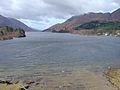
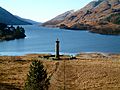
Photo taken at the shore of Loch Sheil behind the monument of the Unknown Highlander, April 2006
.jpg)


