Sgùrr na h-Ulaidh facts for kids
Quick facts for kids Sgùrr na h-Ulaidh |
|
|---|---|

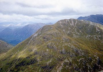
Sgùrr na h-Ulaidh from Beinn Fhionnlaidh, with Bidean nam Bian and Stob Coire nam Beith (right) and Sgorr na Ciche (left)
|
|
| Highest point | |
| Elevation | 994 m (3,261 ft) |
| Parent peak | Bidean nam Bian |
| Listing | Munro, Marilyn |
| Naming | |
| English translation | Peak of the Treasure |
| Language of name | Scottish Gaelic |
| Geography | |
| Location | Glen Coe, Scotland |
| OS grid | NN111518 |
| Topo map | OS Landranger 41 and 50 |
| Climbing | |
| Easiest route | Hike |
Sgùrr na h-Ulaidh (also known as Sgòr na h-Ulaidh) is an amazing mountain in the Scottish Highlands. Its name means "Peak of the Treasure" in Scottish Gaelic. This mountain is located south of the village of Glencoe. You can't see Sgùrr na h-Ulaidh from the main A82 road. This is because another mountain, Aonach Dubh a'Ghlinne, stands in front of it. Sgùrr na h-Ulaidh is a Munro, which means it's one of Scotland's highest mountains. To be a Munro, a mountain must be over 3,000 feet (914.4 meters) tall. It is also a Marilyn, a hill with a certain height above the surrounding land.
Climbing Sgùrr na h-Ulaidh
Most people who want to climb Sgùrr na h-Ulaidh start their hike from Glen Coe. This starting point is about 2 kilometers west of a small lake called Loch Achtriochtan.
The Main Route
To begin the climb, hikers follow a path on the west side of a stream called Allt na Muidhe. After walking for about 1 kilometer, they cross the stream. Then, they continue following the east side of the stream for about 3 kilometers.
At this point, the path turns east. Hikers then climb up to a ridge just north of a peak called Stob an Fhuarain. After reaching Stob an Fhuarain, the route continues along a steep and rocky ridge. This ridge goes towards the south-west, leading directly to the very top of Sgùrr na h-Ulaidh.
Other Climbing Options
There is also another way to climb Sgùrr na h-Ulaidh. This route is from the southern side, in an area called Glen Etive. This option is good because it helps climbers avoid the very steep parts on the mountain's northern side.
 | Precious Adams |
 | Lauren Anderson |
 | Janet Collins |

