
Sharpsville, Indiana facts for kids
Quick facts for kids
Sharpsville, Indiana
|
|
|---|---|

Sharpsville main street
|
|

Location of Sharpsville in Tipton County, Indiana.
|
|
| Country | United States |
| State | Indiana |
| County | Tipton |
| Township | Liberty |
| Area | |
| • Total | 0.23 sq mi (0.60 km2) |
| • Land | 0.23 sq mi (0.60 km2) |
| • Water | 0.00 sq mi (0.00 km2) |
| Elevation | 876 ft (267 m) |
| Population
(2020)
|
|
| • Total | 553 |
| • Density | 2,404.35/sq mi (926.76/km2) |
| Time zone | UTC-5 (Eastern (EST)) |
| • Summer (DST) | UTC-4 (EDT) |
| ZIP code |
46068
|
| Area code(s) | 765 |
| FIPS code | 18-69048 |
| GNIS feature ID | 2397653 |
Sharpsville is a small town located in Liberty Township, Tipton County, Indiana. It is part of the larger Kokomo area. In 2010, about 607 people lived there.
Contents
A Look at Sharpsville's Past


Sharpsville was named after its founder, E.M. Sharp. He came from Washington County, Pennsylvania. Sharp moved to Indiana in 1838 and then to Liberty Township in 1849.
The town was officially planned on May 24, 1850. People thought Sharpsville might become the main town for Tipton County. A town square was included in the plan. It later became a public park instead of a government center. Sharpsville became an official town in 1873. However, it voted to stop being a town in 1881. It then became a village again.
The Sharpsville post office has been open since 1851.
Early Buildings and Churches
Many of the first buildings in Sharpsville were churches. The first Methodist church was built in 1852. The Richland Evangelical Lutheran Church followed in 1857. In 1873, the Hopewell Presbyterian Church was started nearby. Its building was finished in 1874.
Schools in Sharpsville
The first school in Sharpsville opened in 1852. Martha Ann Grishaw was the teacher. School was held in a wooden cabin. Early schools were "subscription schools." This meant families paid a fee for their children to learn.
Later, a high school called Sharpsville-Prairie High School was founded. In 1970, this high school joined with Windfall High School. They formed Tri-Central Middle/High School.
Sharpsville During the Civil War
Sharpsville was home to many people who fought in the American Civil War. On August 9, 1861, a group of soldiers gathered in Sharpsville. They joined the 26th Indiana Infantry Regiment as Company C. Seventy-eight soldiers from Sharpsville were on the Company C list. This group fought in important battles like the Battle of Prairie Grove and the Siege of Vicksburg.
Transportation and Industry
In 1871, a large four-story grain elevator was built. It helped local farmers store their grain. The silos could hold 18,500 bushels. The elevator was taken down in 1990 because it was old.
The grain elevator was served by the Nickel Plate Road railroad. These tracks once connected Sharpsville to Kokomo and Tipton. The train station was removed in 1967. In the early 1900s, Sharpsville also had an interurban rail line. This line connected the town to Peru, Indiana, and Indianapolis. However, this line stopped being used by the mid-1920s.
The Sharpsville Cemetery was started in 1875. It is located southeast of the town.
Sharpsville's Location and Weather
Geography of Sharpsville
Sharpsville covers about 0.24 square miles (0.60 square kilometers) of land. There is no water area within the town limits. Broad Creek is a stream that runs along the south side of Sharpsville.
Climate in Sharpsville
July is usually the warmest month in Sharpsville. High temperatures average 84 °F (29 °C). Lows average 62 °F (17 °C). January is the coldest month. High temperatures average 30 °F (-1 °C) and lows average 15 °F (-9 °C).
The hottest temperature ever recorded was 110 °F (43 °C) in 1936. The coldest was -26 °F (−32 °C) in 1925. The most snow Sharpsville ever got in one day was 16.4 inches. This happened on February 14, 2007.
People of Sharpsville
| Historical population | |||
|---|---|---|---|
| Census | Pop. | %± | |
| 1880 | 280 | — | |
| 1890 | 377 | 34.6% | |
| 1930 | 512 | — | |
| 1940 | 518 | 1.2% | |
| 1950 | 508 | −1.9% | |
| 1960 | 663 | 30.5% | |
| 1970 | 672 | 1.4% | |
| 1980 | 617 | −8.2% | |
| 1990 | 769 | 24.6% | |
| 2000 | 618 | −19.6% | |
| 2010 | 607 | −1.8% | |
| 2020 | 553 | −8.9% | |
| U.S. Decennial Census | |||
Population in 2010
In 2010, Sharpsville had 607 people living in 227 households. Most residents (97.5%) were White. About 28% of the people were under 18 years old. The average age in town was 38.2 years.
Sharpsville's Economy
Historically, farming was the main industry in Sharpsville. Corn and wheat were common crops. Reuben Jackson opened the first general store in Sharpsville. Many other shops opened over time. By 1873, the town had two blacksmith shops. The Sharpsville Bank was started in 1902.
Local Businesses and Manufacturing
In the early 1900s, the Sharpsville Canning Company was the biggest employer. There was also a flour mill and a lumber yard.
Sharpsville was also home to the G.W. Invader Corporation. This company made boats from the early 1960s to the 1980s.
Places to Stay
The first hotel in Sharpsville opened in 1853. By the 1860s, there were three hotels in town.
Town Services and Education
Utilities and Healthcare
Sharpsville gets natural gas from Northern Indiana Public Service Co. (NIPSCO). Electricity is provided by Duke Energy. The Sharpsville Water Utilities Department supplies water and sewage services.
For healthcare, Sharpsville has two hospitals nearby. They are Community Howard Regional Health and Indiana University Health Tipton Hospital.
Education for Students
Students living in Sharpsville attend Tri-Central Community Schools.
Images for kids
-
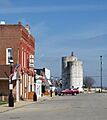
Sharpsville main street
-
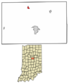
Location of Sharpsville in Tipton County, Indiana.
-
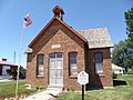
School House, Kelley Historical Museum in Sharpsville
-
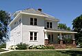
Sharpsville home in Kelley Historical Museum
See also
 In Spanish: Sharpsville (Indiana) para niños
