
Sheeprock Mountains facts for kids
Quick facts for kids Sheeprock Mountains |
|
|---|---|

Sheeprock Mountains
Location in Utah
|
|
| Highest point | |
| Peak | Black Crook Peak |
| Elevation | 9,274 ft (2,827 m) |
| Dimensions | |
| Length | 24 mi (39 km) NW x SE |
| Width | 9 mi (14 km) (+ a very narrow north stretch to the Onaqui Mountains) |
| Geography | |
| Country | United States |
| Communities | Vernon, Lofgreen and Jericho Junction |
The Sheeprock Mountains are a cool mountain range in Utah! They stretch about 24 miles (39 km) long. You can find them in the southeastern part of Tooele County and the northeastern part of Juab County. These mountains are on the edge of a big desert called the Sevier Desert, which is to their southwest.
The Sheeprock Mountains are also close to other interesting areas. About 15 miles (24 km) northwest is Dugway. This area is near the Dugway Proving Ground, which is on the edge of the Great Salt Lake Desert. The northeast side of the Sheeprock Mountains forms the border of Rush Valley. This valley, along with Cedar Valley to the east, collects water but doesn't drain to the ocean. These valleys are just south of the Great Salt Lake area.
About the Mountains
The middle of the Sheeprock Mountains has a ridge that runs southeast for about 10 miles (16 km). The highest point in the range is Black Crook Peak, which is 9,274 feet (2,827 meters) tall. It's located just northwest of the center of the range.
Other tall peaks include Black Peak, at 8,906 feet (2,715 meters), and Dutch Peak, at 8,964 feet (2,732 meters). These two peaks are found in the southeastern part of the ridgeline.
The southeast part of the Sheeprock Mountains connects to other hills and mountains that reach into Rush Valley. This creates a small valley to the west, right next to the northeast side of the Sheeprocks. This mountainous area includes parts of both the southern Sheeprocks and the northern West Tintic Mountains. A place called Red Skin Knolls, which is 7,084 feet (2,159 meters) high, sits between them at the south end of Rush Valley.
At the northwest end of the Sheeprock Mountains, a narrow stretch of hills goes north. These hills connect to the southern part of the Onaqui Mountains. A spot called Lookout Pass separates Little Mountain, which is 6,696 feet (2,041 meters) tall, from Red Pine Mountain in the northern part of the Sheeprocks, which is 8,516 feet (2,596 meters) tall.
How to Visit
You can get to the northeast part of the Sheeprock Mountains through the south of Rush Valley. The easiest way is by using Utah State Route 36 and going to Vernon. From Vernon, the route goes southeast to Lofgreen. Lofgreen is near the northern part of the West Tintic Mountains. While there are farm roads south of Vernon, many creeks and canyons flow northeast from the Sheeprocks. These often have unpaved roads you can use.
To reach the northwest part of the range, you'll need to go from Dugway. Dugway is near the Dugway Proving Ground, which is on the edge of the Great Salt Lake Desert. You can get to Dugway using Utah State Route 199 and Utah State Route 196. From Dugway, you'll use unpaved roads to get into the mountains.
The southern part of the range is accessed by unpaved roads from the Sevier Desert. This area is just west of the southern end of the West Tintic Mountains. You can get to the Sevier Desert from Jericho Junction by taking U.S. Route 6.
Images for kids
-
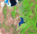
This Landsat photo shows the Sheeprock Mountains (at the southwest) near Rush Valley.

