
Rush Valley facts for kids
Quick facts for kids Rush Valley |
|
|---|---|

(east & southeast)-Rush Valley
(at photo left) |
|

Rush Valley
Location in Utah
|
|
| Geography | |
| Location | United States, Utah, Tooele County |
Rush Valley is a long valley in Tooele County, Utah. It stretches for about 30 miles (48 km) from north to south. This valley is located in the southeastern part of Tooele County.
Rush Valley connects to Tooele Valley in the north. A low area near Rush Lake marks where the two valleys meet. Rush Lake is part of a marshy area. Many streams from the nearby mountains feed into this marsh.
A part of the Tooele Army Depot is located in the valley. This section is in the center-northeast, near the base of the Oquirrh Mountains.
Contents
Exploring Rush Valley's Geography
Rush Valley changes in width as you travel through it. In the northern part, it is about 7 miles (11 km) wide. Here, it sits between the Stansbury Mountains to the west and the Oquirrh Mountains to the east.
As you move south, the valley becomes wider. It splits into two main areas. One area goes straight south, and the other extends to the southeast.
Communities in the Valley
The southern part of Rush Valley is home to the towns of Vernon and Faust. Faust is located more towards the center-south of the valley. Vernon is in a flat area. This area gets water from the Sheeprock Mountains and their foothills.
The southeastern part of the valley is about 16 miles (26 km) long. It lies to the northwest of the East Tintic Mountains. A ridge of land separates Rush Valley from Cedar Valley to the east. In this area, you can find Lofgreen in the mountain foothills. Pehrson and Topliff are in lower areas of the valley.
The two southern sections of the valley together are about 15 miles (24 km) wide. The very center of Rush Valley is just north of Faust. It is also near the small James Walter Fitzgerald Wildlife Management Area. This area helps protect local wildlife.
Getting Around Rush Valley
Several main roads help people travel through Rush Valley.
Major Roads in the Valley
Utah State Route 36 (SR-36) runs right through the middle of the valley. It starts in the northeast, coming from Tooele and Stockton. The road then turns and leaves the valley to the southeast. It eventually reaches the towns of Eureka and Silver City in the East Tintic Mountains.
Utah State Route 73 (SR-73) connects with SR-36 in the center of the valley. This road travels through the southern part of the Oquirrh Mountains. It enters the valley's southeastern section.
From the west, Utah State Route 199 (SR-199) enters the valley center from Dugway. This road goes through a canyon in the western mountains. This canyon acts as a natural dividing line. It separates the Stansbury Mountains to the north from the Onaqui Mountains to the south.
Images for kids
-
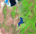
This image shows three valleys from west to east: Skull Valley, the northern part of Tooele Valley and the southern part of Rush Valley, and Cedar Valley. Cedar Valley is the smallest and is located southeast, next to the Lake Mountains and Utah Lake.
-
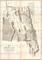
This is a map from 1852 made by Stansbury. It shows Utah and the Great Salt Lake region.


