Shepherd Parkway facts for kids
Quick facts for kids Shepherd Parkway |
|
|---|---|
| Location | District of Columbia |
| Nearest city | Washington, D.C. |
| Area | 205.51 acres (0.8317 km2) |
| Established | 1927 |
| Governing body | National Capital Parks-East, National Park Service |
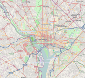
Shepherd Parkway is a large green area in Washington, D.C.. It was an important part of the city's defenses during the American Civil War. Today, you can still find parts of two old forts there: Fort Greble and Fort Carroll. The parkway stretches along high ground, looking out over the Anacostia Freeway. It's located near Joint Base Anacostia–Bolling and is surrounded by neighborhoods like Congress Heights and Bellevue.
Contents
Discover Shepherd Parkway's Past
In 1927, a group called the National Capital Parks and Planning Commission started buying land. Their goal was to create a "Fort Drive" – a ring of parks connecting Civil War defenses around Washington, D.C. Shepherd Parkway was the very first piece of land they bought for this big plan. Even though the full parkway was never finished, this land remains a valuable green space in the city.
How Did Shepherd Parkway Get Its Name?
Shepherd Parkway might be named after Alexander Robey Shepherd. He was the second governor of Washington, D.C., and was born in the city. During the Civil War, he was a soldier. Later, he became successful in the plumbing and gas industries.
As governor, Alexander Shepherd did a lot for the city. He helped pave roads and built a new sewage system. He also encouraged the Baltimore and Ohio Railroad to extend a train line south, which was a big deal for transportation.
Shepherd Parkway During the Civil War (1861-1865)
At the start of the Civil War in 1861, the Union army needed land for defenses. George Washington Young offered to sell his land for $100,000, but the government decided to rent it instead for $6,000 a year. The next year, Young freed his enslaved people when a new law in D.C. made slavery illegal.
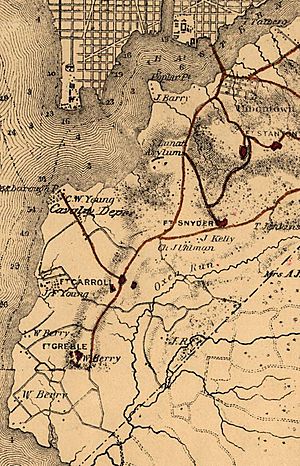
Washington, D.C., was the Union Army's headquarters. To protect it from Confederate attacks, 68 forts were built around the city. Shepherd Parkway was a key area for these defenses. It also had military roads, a cavalry camp called Camp Stoneman, and hospitals.
Fort Carroll and Fort Greble
- Fort Carroll: This fort was named after Samuel Sprigg Carroll, a West Point graduate. It was built on a ridge to protect important places like the cavalry depot and the Washington Arsenal. Fort Carroll was a large fort that could hold over 30,000 horses! It had buildings for soldiers, hospitals, and offices.
- Fort Greble: This fort was named after John T. Greble, a soldier who died in battle in 1861. It was located at the southern end of the Shepherd Parkway ridge. Fort Greble protected the Potomac River and nearby areas. Both Fort Carroll and Fort Greble were used to train soldiers.
Many enslaved people who had escaped to freedom, called "contraband of war," helped build and maintain these forts. After slavery was outlawed by the Thirteenth Amendment to the United States Constitution, many of them stayed in the area. By the end of the 1800s, several African-American communities had grown there.
After the War (1866-1900)
When the war ended, the Freedmen's Bureau bought a farm north of St. Elizabeths Hospital. They divided the land into small lots, about one acre each. These lots were sold to formerly enslaved people. Within two years, 500 families owned their own property there.
The government closed the cavalry camp, and the land went back to George Washington Young. He couldn't sell his buildings, and after he passed away in 1867, his family slowly sold off the property. Fort Carroll was given to the Signal Corps, a branch of the army. Fort Greble was taken down, and its building materials were sold.
Washington, D.C.'s population had doubled during the war, which put a lot of stress on the city. In 1871, a new law combined Georgetown and the city of Washington with Washington County. This was the first step toward the district government we know today.
Early 20th Century Changes
Senator James McMillan from Michigan saw that Washington, D.C., needed improvements. He helped create the McMillan Plan, which aimed to develop a system of parks in the district. This plan included a parkway connecting the old forts.
On April 11, 1927, Shepherd Parkway became the first property bought for this proposed Fort Drive. However, the plan faced challenges because of the Great Depression. In 1933, during the New Deal, most public green spaces were given to the National Park Service. The parkway itself was never fully built, and some of the land was used for anti-aircraft guns and military barracks.
Shepherd Parkway Today
Today, Shepherd Parkway is a beautiful area with 205.51 acres (0.8317 km2) of mature trees. It doesn't have marked trails, picnic spots, or playgrounds. For a while, the parkway was neglected, with trash and unwanted plants. But now, community groups are working hard to clean it up and restore its natural beauty. Shepherd Parkway and the remains of Forts Carroll and Greble are managed by National Capital Parks-East.
External links
 | Janet Taylor Pickett |
 | Synthia Saint James |
 | Howardena Pindell |
 | Faith Ringgold |


