Shire of Mount Marshall facts for kids
Quick facts for kids Shire of Mount MarshallWestern Australia |
|||||||||||||||
|---|---|---|---|---|---|---|---|---|---|---|---|---|---|---|---|

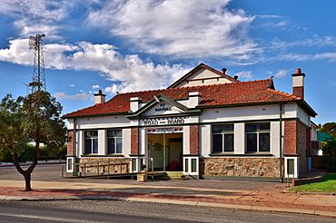
Mount Marshall Shire Hall, Bencubbin, 2018
|
|||||||||||||||

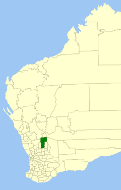
Location in Western Australia
|
|||||||||||||||
| • Density | 0.06/km2 (0.16/sq mi) | ||||||||||||||
| Established | 1923 | ||||||||||||||
| Area | 10,189.5 km2 (3,934.2 sq mi) | ||||||||||||||
| Shire President | Tony Sachse | ||||||||||||||
| Council seat | Bencubbin | ||||||||||||||
| Region | Wheatbelt | ||||||||||||||
| State electorate(s) | Central Wheatbelt | ||||||||||||||
| Federal Division(s) | Durack | ||||||||||||||
 |
|||||||||||||||
| Website | Shire of Mount Marshall | ||||||||||||||
|
|||||||||||||||
The Shire of Mount Marshall is a special area in Western Australia that has its own local government. It's located in the Wheatbelt region, which is known for its farming.
This Shire is about 80 kilometers (50 miles) north-northwest of Merredin. It's also about 300 kilometers (186 miles) northeast of Perth, the capital city of Western Australia. The Shire covers a large area of about 10,190 square kilometers (3,934 square miles). The main town and where the local government is based is called Bencubbin.
Contents
History of Mount Marshall
Let's learn about how the Shire of Mount Marshall came to be!
Early Exploration and Settlement
The first European explorer to visit this area was John Septimus Roe. He was the Surveyor General, which means he was in charge of mapping the land. Mount Marshall and Lake McDermott were named after Marshall McDermott. He was an early settler in the Swan River Colony and worked at a bank.
People started settling here in 1868. The first settlers were mostly sandalwood collectors and graziers. Sandalwood collectors gathered wood from the sandalwood trees, which was valuable. Graziers are people who raise livestock like sheep or cattle. Sandalwood was collected from the 1880s until the 1920s.
Around 1910, more people began to settle permanently. They started clearing the land to create farms.
Forming the Shire
The Mount Marshall Road District was officially created on 6 July 1923. Before this, the area was part of the Ninghan Road District and Nungarin Road District.
A "Road District" was an early form of local government that mainly looked after roads. On 1 July 1961, the Local Government Act 1960 was passed. This law changed all remaining road districts into "shires." That's how the Mount Marshall Road District became the Shire of Mount Marshall, which is what it is today.
How the Shire is Governed
The Shire of Mount Marshall has a local government that helps manage the area.
Councillors and Representation
The Shire does not have "wards." Wards are like smaller sections or districts within a larger area. Instead, all the Councillors (who are like local politicians) represent the entire Shire of Mount Marshall. This means they work for the benefit of everyone in the whole district, as required by the Local Government Act 1995.
Towns and Localities
The Shire of Mount Marshall includes several towns and smaller areas called localities. Here's a look at them, with their populations and sizes from the most recent Australian census:
| Locality | Population | Area | Map |
|---|---|---|---|
| Beacon | 123 (SAL 2021) | [convert: needs a number] | |
| Bencubbin | 203 (SAL 2021) | [convert: needs a number] | |
| Bimbijy | 0 (SAL 2016) | [convert: needs a number] | |
| Cleary | 3 (SAL 2021) | [convert: needs a number] | |
| Gabbin | 44 (SAL 2021) | [convert: needs a number] | |
| Karroun Hill | 0 (SAL 2016) | [convert: needs a number] | |
| Mouroubra | 0 (SAL 2016) | [convert: needs a number] | |
| Remlap | 0 (SAL 2016) | [convert: needs a number] | |
| Tampu | 18 (SAL 2021) | [convert: needs a number] | |
| Welbungin | 35 (SAL 2021) | [convert: needs a number] | |
| Wialki * | 45 (SAL 2021) | [convert: needs a number] |
- (* indicates locality is only partially located within this shire)
Heritage Places
In 2023, there were 50 places in the Shire of Mount Marshall that are considered "heritage-listed." This means they are important historical sites or buildings. None of these places are on the State Register of Heritage Places, which is a special list of the most important heritage sites in the state.
 | Georgia Louise Harris Brown |
 | Julian Abele |
 | Norma Merrick Sklarek |
 | William Sidney Pittman |

