Shire of Woocoo facts for kids
Quick facts for kids Shire of WoocooQueensland |
|||||||||||||||
|---|---|---|---|---|---|---|---|---|---|---|---|---|---|---|---|

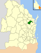
Location within Queensland
|
|||||||||||||||
| Population | 3,351 (2006 census) | ||||||||||||||
| • Density | 1.66891/km2 (4.3225/sq mi) | ||||||||||||||
| Established | 1914 | ||||||||||||||
| Area | 2,007.9 km2 (775.3 sq mi) | ||||||||||||||
| Council seat | Oakhurst | ||||||||||||||
| Region | Wide Bay–Burnett | ||||||||||||||
 |
|||||||||||||||
| Website | Shire of Woocoo | ||||||||||||||
|
|||||||||||||||
The Shire of Woocoo was a special area in Queensland, Australia. It was like a local government, which means it had its own council to manage local services. This area was in the Wide Bay–Burnett region.
It covered about 2,000 square kilometers, which is a pretty big space! The Shire of Woocoo existed from 1914 until 2008. In 2008, it joined with other nearby areas to become part of the Fraser Coast Region.
The main jobs and businesses in the Shire of Woocoo were raising beef cattle, growing sugar, cutting timber, and some smaller industries that helped the nearby town of Maryborough.
Contents
History of Woocoo Shire
The Shire of Woocoo officially started on December 4, 1914. Before that, it was part of another area called the Shire of Tiaro. It also included parts of the Shires of Antigua and Howard.
The name "Woocoo" came from Mount Woocoo. People think the mountain's name came from an Aboriginal word for "echidna". The first meeting of the Woocoo Shire council happened on January 30, 1915. Its main office was in a town called Brooweena.
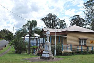
Woocoo War Memorial
In 1922, the people of Woocoo Shire built a special memorial. It was to remember the soldiers from the area who fought in wars. This memorial was first placed near a church in Teebar.
Major-General Thomas William Glasgow officially opened it on January 6, 1923. Later, in 1992, the memorial was moved to the Woocoo Historical Museum in Brooweena. This was done to keep it safe. Now, it is known as the Brooweena War Memorial.
Changes Over Time
The size of the Shire of Woocoo changed a few times. In 1976, it grew bigger by about 1,269 square kilometers. This happened when the Shire of Burrum became the Shire of Hervey Bay.
Then, in 1994, about 700 square kilometers of Woocoo's land became part of Maryborough. After this, Woocoo was divided into three sections. Each section elected two councillors to represent its people.
Joining the Fraser Coast Region
On March 15, 2008, a big change happened. The Shire of Woocoo joined with the City of Hervey Bay, the City of Maryborough, and part of the Shire of Tiaro. Together, these areas formed the new Fraser Coast Region. This change was part of a plan by the Queensland government.
Towns and Localities in Woocoo
The Shire of Woocoo included several small towns and areas. These were the places where people lived and worked:
- Antigua
- Aramara
- Bidwill
- Boompa
- Brooweena
- Dunmora
- Grahams Creek
- Mungar
- Oakhurst
- Owanyilla
- Tinana South
- Woocoo
- Yengarie
Population Changes
The number of people living in the Shire of Woocoo changed over the years. Here's a look at how the population grew and shrank:
| Year | Population |
|---|---|
| 1933 | 777 |
| 1947 | 750 |
| 1954 | 660 |
| 1961 | 640 |
| 1966 | 567 |
| 1971 | 491 |
| 1976 | 3,412 |
| 1981 | 4,456 |
| 1986 | 2,700 |
| 1991 | 3,429 |
| 1996 | 2,902 |
| 2001 | 2,964 |
| 2006 | 3,351 |
The population saw a big jump in 1976. This was because the shire's boundaries changed, adding more people to the area.
 | James Van Der Zee |
 | Alma Thomas |
 | Ellis Wilson |
 | Margaret Taylor-Burroughs |


