Shire of Isis facts for kids
Quick facts for kids Shire of IsisQueensland |
|||||||||||||||
|---|---|---|---|---|---|---|---|---|---|---|---|---|---|---|---|

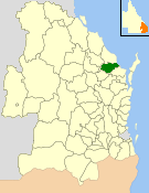
Location within Queensland
|
|||||||||||||||
| Population | 6,298 (2006 census) | ||||||||||||||
| • Density | 3.6999/km2 (9.583/sq mi) | ||||||||||||||
| Established | 1887 | ||||||||||||||
| Area | 1,702.2 km2 (657.2 sq mi) | ||||||||||||||
| Council seat | Childers | ||||||||||||||
| Region | Wide Bay–Burnett | ||||||||||||||
 |
|||||||||||||||
| Website | Shire of Isis | ||||||||||||||
|
|||||||||||||||
The Shire of Isis was a special area in Queensland, Australia. It was a type of local government area. This means it had its own local council to manage things. The Shire of Isis was located in the Wide Bay–Burnett region. It was south of the city of Bundaberg.
The main town and administrative center for the Shire was Childers. The Shire covered a large area of about 1,702 square kilometers. It existed as a local government area for many years, from 1887 until 2008. In 2008, it joined with other nearby areas. These areas formed the larger Bundaberg Region.
Contents
History of the Shire of Isis
How the Shire of Isis Started
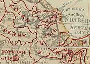
The area first became a local government division on January 1, 1887. It was called the Isis Division. This happened because of a law named the Divisional Boards Act 1887. Before this, the land was part of the Burrum Division.
Becoming the Shire of Isis
A new law was passed in 1902. It was called the Local Authorities Act 1902. Because of this law, the Isis Division changed its name. On March 31, 1903, it officially became the Shire of Isis.
Joining the Bundaberg Region
On March 15, 2008, a big change happened. The Shire of Isis merged with other local areas. These included the City of Bundaberg and the Shires of Burnett and Kolan. They all came together to form the new Bundaberg Region. This merger was part of a plan by the Parliament of Queensland. The plan was set out in the Local Government (Reform Implementation) Act 2007.
Places in the Shire of Isis
The Shire of Isis included several towns and smaller communities. These were the main settlements within its boundaries:
- Childers
- Apple Tree Creek
- Booyal
- Buxton
- Cordalba
- Doolbi
- Farnsfield
- Goodwood
- Horton
- Isis Central
- North Isis
- Redridge
- Woodgate
Leaders of the Shire
The Shire of Isis was led by people called Chairmen. They were like the head of the local council. They helped make important decisions for the community. Here are some of the Chairmen and the years they served:
- 1927 - 1930 T. Gaydon
- 1930 - 1939 A. Adie
- 1939 - 1949 E. P. Noakes
- 1949 - 1970 F. E. Eastaughffe
- 1970 - 1988 A.W. Paith
Some of these Chairmen served for multiple terms.
How Many People Lived Here?
This table shows how the number of people living in the Shire of Isis changed over many years. It gives us an idea of its population growth.
| Year | Population |
|---|---|
| 1933 | 3,778 |
| 1947 | 3,639 |
| 1954 | 4,243 |
| 1961 | 3,951 |
| 1966 | 3,718 |
| 1971 | 3,666 |
| 1976 | 3,926 |
| 1981 | 4,023 |
| 1986 | 4,082 |
| 1991 | 4,825 |
| 1996 | 5,878 |
| 2001 | 6,045 |
| 2006 | 6,663 |
 | Madam C. J. Walker |
 | Janet Emerson Bashen |
 | Annie Turnbo Malone |
 | Maggie L. Walker |


