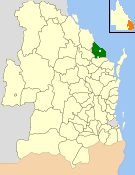
Shire of Burnett facts for kids
Quick facts for kids Shire of BurnettQueensland |
|||||||||||||||
|---|---|---|---|---|---|---|---|---|---|---|---|---|---|---|---|

Location within Queensland
|
|||||||||||||||
| Population | 27,232 (2006 census) | ||||||||||||||
| • Density | 13.6106/km2 (35.251/sq mi) | ||||||||||||||
| Established | 1994 | ||||||||||||||
| Area | 2,000.8 km2 (772.5 sq mi) | ||||||||||||||
| Council seat | Bargara (160 Hughes Rd) | ||||||||||||||
| Region | Wide Bay–Burnett | ||||||||||||||
 |
|||||||||||||||
| Website | Shire of Burnett | ||||||||||||||
|
|||||||||||||||
The Shire of Burnett was a special area in Queensland, Australia. It had its own local government, like a local council, that managed the area. This shire was located in the Wide Bay–Burnett region. It surrounded the city of Bundaberg, but Bundaberg itself was not part of the shire.
The Shire of Burnett covered about 2,000 square kilometres (770 square miles). It existed from 1994 until 2008. In 2008, it joined with the City of Bundaberg and other nearby councils to form the larger Bundaberg Region.
History of the Shire of Burnett
In 1991, a group called the Electoral and Administrative Review Commission looked at how local areas were managed. They suggested that the boundaries of local governments around Bundaberg should be changed.
Because of these suggestions, two shires, the Shire of Gooburrum and the Shire of Woongarra, joined together. This joining is called an amalgamation. A new law was made in December 1993 to make this happen.
On March 30, 1994, the Shire of Burnett officially began. Some newer urban areas were also moved to be part of the City of Bundaberg at this time.
Later, on March 15, 2008, the Shire of Burnett joined with other councils. It merged with the City of Bundaberg, the Shire of Isis, and the Shire of Kolan. Together, they formed the new and larger Bundaberg Region.
Population Growth in the Shire
The population of the areas that became the Shire of Burnett grew a lot over the years. The table below shows how many people lived in the Gooburrum and Woongarra shires before they joined. It also shows the population of the Shire of Burnett after it was formed.
| Year | Population (total) |
Population (Gooburrum) |
Population (Woongarra) |
|---|---|---|---|
| 1921 | 5,435 | 2,922 | 2,513 |
| 1933 | 7,202 | 3,915 | 3,287 |
| 1947 | 7,170 | 3,825 | 3,345 |
| 1954 | 7,835 | 4,131 | 3,704 |
| 1961 | 8,521 | 4,372 | 4,149 |
| 1966 | 9,710 | 4,776 | 4,934 |
| 1971 | 9,669 | 4,519 | 5,150 |
| 1976 | 14,018 | 5,227 | 8,791 |
| 1981 | 15,126 | 5,261 | 9,865 |
| 1986 | 17,832 | 5,917 | 11,915 |
| 1991 | 23,608* | 7,117 | 16,491 |
| 1996 | 21,218* | ||
| 2001 | 23,598 | ||
| 2006 | 27,232 |
* The population of Burnett was 15,417 in 1991 if you only count the area that became the Shire of Burnett in 1994.
Towns and Localities in the Shire
The Shire of Burnett included many towns and smaller communities, also known as localities. These were divided into a North Burnett area and a South Burnett area.
|
North Burnett area:
|
South Burnett area:
|
1 - part of this area was also in the Gladstone Region
2 - part of this area was also in the former City of Bundaberg
 | Sharif Bey |
 | Hale Woodruff |
 | Richmond Barthé |
 | Purvis Young |

