South Kolan facts for kids
Quick facts for kids South KolanQueensland |
|||||||||||||||
|---|---|---|---|---|---|---|---|---|---|---|---|---|---|---|---|

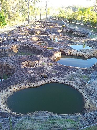
Mystery Craters, 2013
|
|||||||||||||||
| Population | 1,258 (2021 census) | ||||||||||||||
| • Density | 11.064/km2 (28.66/sq mi) | ||||||||||||||
| Postcode(s) | 4670 | ||||||||||||||
| Area | 113.7 km2 (43.9 sq mi) | ||||||||||||||
| Time zone | AEST (UTC+10:00) | ||||||||||||||
| Location | |||||||||||||||
| LGA(s) | Bundaberg Region | ||||||||||||||
| State electorate(s) | Burnett | ||||||||||||||
| Federal Division(s) | Flynn | ||||||||||||||
|
|||||||||||||||
South Kolan is a small rural area in the Bundaberg Region of Queensland, Australia. It's a quiet place where people live and work, often involved in farming. In 2021, about 1,258 people called South Kolan home.
Contents
Exploring South Kolan's Location
South Kolan is part of the Wide Bay–Burnett region in Queensland. It is located about 354 kilometers (220 miles) north of Brisbane, the state capital. The regional city of Bundaberg is only 23 kilometers (14 miles) to the southwest. The important Burnett River flows right through this area.
What are the Neighborhoods in South Kolan?
South Kolan includes a few smaller neighborhoods, each with its own history.
Birthamba: A Historic Camp Site
The neighborhood of Birthamba is in the northeastern part of South Kolan. Its name comes from the old Birthamba railway station. The word Birthamba means camp in an Aboriginal language.
Kalbar: A Former Plantation Area
Kalbar is another neighborhood in the eastern part of South Kolan. You can still find Kalbar Road there today. This area is near a bend in the Burnett River. It used to be home to the Kalbar Plantation, which had a sugar mill in 1883.
Koolboo: Named After a Leader
In the northwestern part of South Kolan, you'll find the Koolboo neighborhood. It was named after the old Kooboo railway station. Koolboo is the name of a local Aboriginal clan leader.
Roads Connecting South Kolan
The main road running through South Kolan from east to west is the Bundaberg-Gin Gin Road. Another important road, The Cedars Road, heads south from the area.
A Look at South Kolan's Past
The name Kolan is thought to come from the Kabi language word kalang, which means good.
Early Schools and Churches
Education has been important in South Kolan for a long time.
- Kolan South State School first opened its doors on July 29, 1878.
- Kalbar Provisional School started on February 26, 1896, and became a State School in 1909. It closed in 1962.
- Bingera Railway Station Provisional School opened in 1907 and became a State School in 1909. It closed in 1963.
Churches also played a role in the community's history.
- A Methodist church was built in 1882 in an area called Hill End. A new building replaced it in 1903.
- A Union church opened in 1884 and was used by different church groups.
- St Mary's Anglican Church was dedicated in 1979 but closed in 1994.
Dealing with Floods
South Kolan has faced challenges from floods, especially in 2010-2011 and 2013. These floods caused damage, and a lot of work was done to fix roads and bridges, like the Cedars Road Bridge Crossing.
What South Kolan Does Today
The main industries in South Kolan are farming. People here raise cattle and grow sugar cane, which is then processed at mills. They also grow various fruits and vegetables.
Local Services and Facilities
Even though it's a small town, South Kolan has some important services:
- A convenience store for daily needs.
- Kolan South State Primary School for younger students.
- A police station to keep the community safe.
- The South Kolan Pub, which is a local gathering spot and offers accommodation.
Many people from nearby rural areas like Pine Creek and Gin Gin also visit South Kolan.
Education in South Kolan
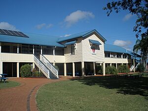
Kolan South State School is a government primary school for students from Prep to Year 6. It's located at 2297 Gin Gin Road. In 2018, the school had 112 students.
There are no high schools directly in South Kolan. Older students usually attend high schools in nearby towns. The closest government secondary schools are Bundaberg North State High School in Bundaberg North and Gin Gin State High School in Gin Gin.
Discover the Mystery Craters
One of the most interesting places in South Kolan is the Mystery Craters. These 35 unusually shaped craters were found in 1971. No one is completely sure how they were formed, which makes them a fascinating puzzle!
South Kolan's Climate
South Kolan has a subtropical climate. This means it has hot and wet summers. The winters are usually mild, making it a pleasant place to live for much of the year.
 | Dorothy Vaughan |
 | Charles Henry Turner |
 | Hildrus Poindexter |
 | Henry Cecil McBay |


